
Lianjiang County: The County Furthest from Taiwan, Closest to the Cold War
30-second overview: Lianjiang County is one of the two counties in Fujian Province currently administered by the Republic of China (ROC), comprising 4 townships, 5 main islands, and 36 islets, with a total area of 28.8 square kilometers. Nangan is about 50 kilometers from Fuzhou city center, and just 9.25 kilometers from the northern tip of the Beihai Peninsula (the closest point to the Chinese mainland), yet over 200 kilometers from Taipei. After the end of the Chinese Civil War in 1949, "Lianjiang County" was split in two: the county seat remained in the CCP-controlled Lianjiang, while the ROC government relocated to Nangan. From 1956, it entered a 36-year period of wartime administrative controls, including a 9 PM curfew, a two-story building height limit, and the requirement for Matsu residents to obtain travel permits to visit Taiwan. Wartime administrative controls in Kinmen and Matsu were lifted on November 7, 1992. In 2012, a referendum in Matsu passed to establish a gaming zone—the first successful local referendum in Taiwan. Thirteen years later, no casinos have been built. Today, 13,646 people live here, and the Mazu language (Eastern Min) has been lost by 94% of the third generation in Taoyuan's Bade City.
Looking North from the Mountain Top of Nangan, Fuzhou City Lies 16 Kilometers Away
If you stand on the ridge of Jiushou Village in Nangan Township and look northward, on a clear day the outline of downtown Fuzhou emerges on the horizon.
From Nangan to the nearest coast of the mainland (Beijia Peninsula), the straight-line distance is only 9.25 kilometers. Pushing further inland to downtown Fuzhou, it's about 50 kilometers1. Turning around to look southward at the Taiwan mainland, the straight-line distance to Taipei exceeds 200 kilometers, and the ferry from Keelung Port to Nangan's Fuhao Port takes 8 to 10 hours.
The geographical reality of Lianjiang County is this: it is nearly thirteen times closer to Fuzhou on the mainland than to the capital of its own country.
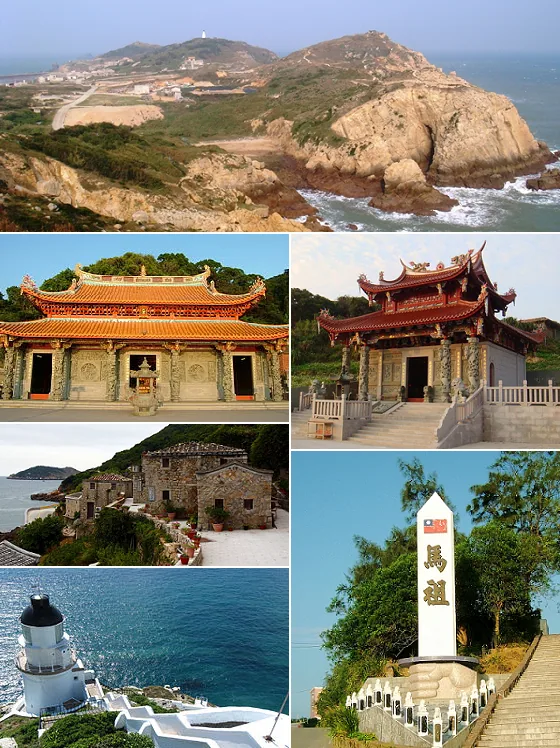
Image credit:Sleepingstar / Wikimedia Commons · CC BY-SA 3.0 · Original source
Yet this county is named "Lianjiang." Within Fujian Province of the People's Republic of China, there is also a "Lianjiang County," with its seat in Fengcheng Town downstream of Fuzhou, which was captured by the PLA in the final summer of the Chinese Civil War in 1949. The ROC government of Lianjiang County then retreated to the Matsu Islands and re-established the county office in Nangan in August 19532. One county split in two—one half remaining under the Chinese Communist Party, the other becoming a county of Taiwan. This is unique among all 22 counties and cities in Taiwan.
Lianjiang County does not belong to Taiwan Province; together with Kinmen County, it belongs to "Fujian Province." This province remains one of the two provinces in the ROC constitutional framework, although since 1998 the provincial government has been streamlined, and in 2019 the Fujian Provincial Government was officially defunct, with its duties transferred to the Joint Services Center of the Ministry of Internal Affairs for Kinmen and Matsu3. Nevertheless, on identity cards, in household registration systems, and on map markings, people of Lianjiang are still registered as residents of "Fujian Province, Lianjiang County."
To understand this county, one must first set aside the intuition that "an island must belong to the nearest country." Lianjiang is a county of Taiwan, but it has never been geographical Taiwan.
The Liangdao People Are 7,900 Years Old — Thousands of Years Older Than Confucius
In 2012, the Republic of China (ROC) military, during construction work on the northern part of Liangdao, unearthed two complete sets of human bones.
Archaeologist Chen Zhongyu and his team named them "Liangdao Person No. 1" and "Liangdao Person No. 2." Mitochondrial DNA analysis revealed that Liangdao Person No. 1 shares a common matrilineal ancestry with Taiwan's Tsai (Indigenous) and Amis peoples, and may be among the earliest ancestors of the Austronesian language family4.
Carbon-14 dating of the Liangdao Island Tail archaeological site indicates an age of 7,000 to 8,300 years. In 2023, the Ministry of Culture designated it as Taiwan's 11th national archaeological site, and it is also the earliest Neolithic site discovered within Taiwan's territory5.
Liangdao itself is a military zone, off-limits to civilians. Archaeological excavations required negotiation with the ROC military for access windows, with soldiers standing guard during the dig. A 7,900-year-old human bone was guarded by a Cold War-era military cordon for over 70 years — this contrast itself encapsulates the compressed history of Lianjiang County.
The Song Dynasty's Liang Keqia's Three Mountains Gazetteer already records "Gan Tang" (the former name of the Matsu archipelago). The Dapu Stone Carvings in Nangan's Tieban Village bear the inscription "Zhongtong Exchange Coins, 20 Guan," referring to Zhongtong coins from the Yuan Dynasty, proving that settlements existed in Nangan during the Yuan Dynasty6. Fishermen from the Mingdong region settled on different islands according to their hometowns: Dongju and Xiju belonged to Changle County, while Dongyi and Xiyi belonged to Luoyuan County7. Fujianese fishermen have lived on these islands for over a millennium — they were not "discovered" by outsiders.
📝 Curator's Note: The mainstream narrative of Taiwan's outlying islands is "battlefield tourism," "blue-eyed tears," and "supply ships." This framing compresses Matsu into a Cold War artifact, as if the island only began to exist in 1949. The significance of the Liangdao archaeological discovery lies in stretching the timeline: human activity in this sea area has spanned 8,000 years, and the 75 years of the Chinese Civil War are merely the final, brief segment. The ancestral graves of Mingdong fishermen, the stone sarcophagi of Mazu legends, and the coins of the Song and Yuan dynasties all predate the Cold War — they are not annotations to Cold War history.
The 41-Character Inscription of 1617
On the slope of Lao Tou Mountain at the southernmost tip of Dongju Island, there is a cliff-carved stone inscription.
In May 1617 (the 45th year of the Ming Wanli era), military commander Shen YouRong defended the Minhai coast and fiercely resisted Japanese pirates at Dongsha (today's Dongju Island), capturing 69 of them without losing a single soldier8. In 1630 (the 3rd year of the Ming Chongzhen era), Imperial Secretary of Works Dong Yingju carved a stone stele to commemorate this battle. The 41 characters of the inscription read:
“After the vast wilderness of the strong Wanli era fell to the land, the sun rose in the east. Shen YouRong of Xingzhou captured sixty-nine Japanese pirates at the mountains of Dongsha without losing a single soldier. This is inscribed by Dong Yingju of the Min people.”9
This “Dapu Stone Carving” is the oldest and largest existing cliff-carved stone in the Matsu region, and is today designated a county-level historic relic of Lianjiang County. It was discovered in 1953 when the Republic of China military occupied Dongju and constructed defensive fortifications, at which time it was enclosed in wire mesh for protection10.

Shen YouRong is also recorded elsewhere in Taiwan's history. In 1604, he ordered the Dutch East India Company commander Verbeeck to withdraw from the Pescadores; this is commemorated on the “Shen YouRong Orders the Dutch Commander Verbeeck to Withdraw” stele, housed in the existing Pescadores Tianhou Temple, designated a national treasure-level cultural artifact in 202211. The same Ming general, within 13 years, suppressed two maritime conflicts at opposite ends of the Taiwan Strait: one against Japanese pirates, one against the Dutch.
During the Franco-Chinese War (1884–1885), French naval forces blockaded the Taiwan Strait and attacked Keelung; the Matsu archipelago, located offshore at the mouth of the Min River, was a possible supply point for the French. However, this war ultimately did not result in any actual attack on Matsu; direct contact between Matsu and modern warfare would have to wait another 70 years.
During the Qing Dynasty (1683–1895), Lianjiang County fell under the jurisdiction of Fuzhou Prefecture, Fujian Province, and the Matsu islands were administered as outer sea islands under Lianjiang County. For over 200 years during this period, Matsu was a group of islands where fishermen temporarily made their living; there was no county seat, no large-scale land reclamation, and no academies. It was a maritime frontier of the Chinese coast, until 1949, when the Republic of China transformed this frontier into its own front line.
After 9 PM, No One Moves on the Entire Island
In July 1956, the Matsu War Zone Political Affairs Commission was established.
From that year until November 7, 1992, when the Matsu War Zone Political Affairs was terminated, Lianjiang County experienced a complete 36 years of military-centralized rule12. Taiwan proper lifted martial law in 1987, but Matsu held on for another 4 to 5 years before ending the martial law system.
What was daily life like for local residents during these 36 years?
The National Cultural Heritage Database's entry "Curfew Hours, Military Orders Are Supreme" records verbatim several basic rules: "The curfew time is after 9 PM." "During curfew hours, no activities may be held anywhere on the island"; "Military and civilians going out must know the password, otherwise they will be caught — lightly punished with detention, severely with imprisonment"; "If a major accident occurs and it is absolutely necessary to go out, one must apply for a permit to the relevant unit, or inform the curfew password content in order to pass through"13. The most direct sentence is written like this: "Once a sentry detects anything unusual, he shouts 'the password'; if no response is received, he assumes it is the enemy and will shoot without hesitation"13.
How many military personnel were there? At its peak, the Matsu Defense Command had a total strength of approximately 50,000 people14, while the local resident population was about 10,000 people, a military-to-civilian ratio of 5 to 1. A 28.8 square kilometer archipelago was home to the forces of 5 divisions.
Material life controls were also very detailed: radios and televisions had to be applied for before use; refrigerators, washing machines, electric rice cookers, and air conditioners were banned in Matsu; buildings were not allowed to exceed two stories; cameras could not be used freely; tires, life rings, and basketballs — these "floating objects" — were prohibited from being introduced, fearing residents would use them to swim to the mainland; firecrackers could not be set off, and betel nuts could not be chewed; pigeons could not be raised, and kites could not be flown15. The Matsu area even issued its own military tickets, which had to be exchanged when traveling between Taiwan, Penghu, and Matsu.
When Chiang Kai-shek inspected Matsu in 1958, he personally inscribed four characters: "On alert day and night"16, meaning to remain vigilant at all times, even while sleeping. Today, you can still see this stone carving in Jiushan Park, Nangan Township, and the sign "Never Forget Being in Matsu" at the Matsu Pier, with slogans from the military government era scattered on the walls of the villages — "Ensure Matsu," "Recover the mainland territories," "Liberate our compatriots on the mainland"16. These slogans are physical traces left by 36 years of actual governance, not touristy decorations.
On May 1, 1991, the Temporary Provisions Effective During the Period of Communist Rebellion were abolished; on November 7, 1992, the Matsu area officially ended the experimental period of war zone political affairs and lifted the martial law order12. But even after the war zone political affairs ended, the people of Matsu still had to wait nearly two more years to come to Taiwan proper: it was not until May 13, 1994, that the entry and exit permits between Taiwan, Penghu, and Matsu were formally abolished by law.
The "Passport" That Brought Matsu People to Taiwan 30 Years Ago
In a 2023 interview, current Lianjiang County Magistrate Wang Zhongming pulled out a yellowed document to show journalists.
That was the "Exit and Entry Permit" used by people from the Matsu Islands to travel to Taiwan proper before the martial law was lifted in 1992. He said: "This exit and entry permit was kind of like a passport; we had to apply for it every time we went to Taiwan17."
To enter Taiwan proper, people from the Matsu Islands had to apply to the Ministry of the Interior's National Immigration Agency. Every detail—forms, photos, purpose, expected return date—had to be explained clearly. For Matsu people entering Taiwan, this was administratively the same as foreigners entering Taiwan. A county resident of the Republic of China having to obtain a passport-like document to visit their own capital is a case that is hard to find in world constitutional history.
This "passport" is a material legacy of wartime governance, and also a form of physical embodiment of identity: although you are a resident of Lianjiang County, Republic of China, you cannot freely enter other parts of the Republic of China. Between 1956 and 1994, people from the Matsu Islands were effectively "semi-foreigners" within the territory of the Republic of China.
✦ "If Taiwan doesn't want us, and we don't want to be Chinese, what should we do?"18
This quote comes from a report by Mingrentang on the identity of young people in the Matsu Islands. It precisely articulates the existential dilemma of Lianjiang County in 2026: we are administratively part of Taiwan, but our ancestry, language, geography, and beliefs are closer to Fujian; we have a democratically elected county magistrate and voting rights, but our history was shaped by the Cold War frontier.
The 2012 Gaming Referendum, 13 Years With No Follow-Up
After the end of wartime political affairs, the people of Matsu tried another form of "self-determination": local civic referendums.
On July 7, 2012, Lianjiang County held a referendum on "Whether Matsu Should Establish an International Tourist Resort with Attached Tourist Casinos." There were 7,762 registered voters, with a turnout of 40.76% (3,164 votes cast). The vote passed with 1,795 approvals (57.24%) against 1,341 rejections (42.76%), a margin of 454 votes19.
This was Taiwan's first successful local civic referendum, the third local referendum since the Referendum Act took effect in 2004. The two gaming referendums in Penghu County in 2009 and 2016 were both rejected by majority vote (56.44% opposed / 60.1% opposed); the 2023 gaming referendum in Kinmen was likewise rejected by a large margin. Only the people of Matsu said: Let's give it a try20.
The reason was economic. Matsu's transportation was inconvenient, tourism had long off-seasons, and young people flowed out to Taiwan's main island for education and work. At that time, the county government partnered with Taiwan's Hau De Development Company to plan an international tourist resort in Beigan, featuring casinos, five-star hotels, and conference centers, positioning it as a Northeast Asian gaming hub close to both the Chinese mainland and Japan/Korea.
The referendum passed. And then there was no "then."
The local referendum only cleared the first hurdle. To actually open casinos, the Gaming Casino Administration Ordinance Draft still needed to pass the Legislative Yuan. In December 2013, the Executive Yuan reviewed the relevant draft, but with differing positions from all sides, it reached a stalemate and was dismissed without passing21. In 2015, Taiwan Hau De Company quietly withdrew from the Matsu gaming development, citing "the gaming special law has not passed." As of today in 2026, 13 years have passed, the casino has not been built, and the gaming special law has not been enacted22.
Lianjiang County Government Secretary-General Zhang Longde said in 2017: "In recent years, Matsu no longer relies on, nor needs to rely on, the gaming dream, but instead develops tourism on its own"22. This sounds like letting go, but the fact that the central government blocked things for 13 years remains: the people of Matsu passed their decision through democratic procedure, but without coordination from the central legislature, local will just spins in place22.
This case is a meaningful observation point for Taiwan's constitutional system. Local referendums are democratic, but democracy's range was cut off at the central legislature. The people of Matsu spent 36 years emerging from the battlefield, and then another 13 years discovering that their decision still could not get past that wall.
The Same Language, Three Names: Hokkien, Fuzhounese, and Matsu
The mother tongue of Matsu people is completely different from the Taiwanese Hokkien, Hakka, and indigenous languages of Taiwan's main island.
It is Hokkien, nearly identical to the Fuzhounese spoken in the city of Fuzhou23. Most Matsu people are descended from Longyue County, with some from Luoyuan and various counties of Fuzhou, so this language is also called "Longyue dialect," "Fuzhounese," or "Matsu dialect"—different names for the same Hokkien language. It is completely unintelligible with Hokkien (the Taiwanese Hokkien of Taiwan's main island): the two systems have been separate for over a millennium in phonology, vocabulary, and grammar.
In 2017, the Republic of China government officially designated Matsu as one of Taiwan's national languages24. In 2019, the National Languages Development Act was enacted, making Matsu a legally protected language. Taiwan's mother tongue family thus gained a "fourth" branch—Hokkien, Hakka, the indigenous languages, and now the Hokkien branch of Matsu.
But language loss is extremely severe.
A straightforward English study of Matsu language published by Taiwan Insight states: "Less than 30% of Matsu households currently speak in their mother tongue. Some elders believe that this is a dying language." (Currently, fewer than 30% of Matsu households use their mother tongue. Some elders believe this is a dying language.) The same article also records another quote: "The ban on speaking in dialects was painful and hastened the crisis of language extinction." (The past policy of banning dialects was painful and accelerated the crisis of language extinction.)25
The local language situation in Matsu is much more severe than on Taiwan's main island. The Wikipedia entry on Matsu language verbatim states: "In recent years, with the opening of Matsu to tourism and the large-scale migration of people to Taiwan's main island, many local Matsu residents have begun speaking Hokkien-Taiwanese. The Matsu dialect, as a mother tongue, faces a crisis of decline, with younger generations speaking it less or not at all."26
More urgent figures come from Taoyuan's Bade City: "The Matsu language has been lost at a rate of up to 94% over the past three generations, placing it in the 'severely endangered' category."17
Taoyuan's Bade City is the largest settlement of Matsu people on Taiwan's main island. In the 1960s and 70s, as fisheries declined and the textile industry rose, large numbers of Matsu people went to work in textile factories in Taoyuan's Bade City. Today, the permanent population of Matsu Island is about 13,000 people, while the estimated 50,000 to 60,000 Matsu descendants in Taoyuan's Bade City number 4 to 5 times the island's population17. The Matsu people have a self-identification saying: "Four townships, five islands, plus Bade."
The root cause of language loss can be traced back to wartime political affairs 36 years ago. Starting in 1956, after the National Army moved in, there was a strong push to promote Mandarin and literacy campaigns, with the motivation of "military-civil cooperation and joint combat." The Matsu Defense Command set up "instructors" in each village, forcing adults to learn Mandarin and children to study and become literate27. Mandarin literacy was a public health success, but for the Matsu language, it was a linguistic earthquake.
📝 Curator's Note: The popular science narrative says "Matsu language and Fuzhounese are both Hokkien," which is linguistically correct, but it places Matsu language within a "Chinese dialect island" coordinate system. A more accurate perspective is: Matsu language is a Hokkien coordinate on Taiwan's linguistic map, just like Kinmen dialect (belonging to the same Hokkien branch but with different tones), Yilan Toucheng dialect, Pingtung Manzhou dialect, and Penghu Bisha dialect—all part of Taiwan's mother tongue diversity. When Matsu language loses 94%, Taiwan loses an internal dimension of itself as a multilingual society.
Tourism Before and After: Matsu, Blue Tears, and Qinbi Stone Houses
In the tourism promotion of Lianjiang County, three anchors appear most frequently: Matsu, Blue Tears, and Qinbi. Each has its own original story, and its own story after tourism development.
Mazu's story begins with a legend. During the Song Dynasty, Lin Moying threw herself into the sea to rescue her drowning brothers, and her body drifted ashore near Nangan Island. Fishermen pulled her from the water, admired her filial piety, and buried her on the coast.
There are two versions of what happened next. The version on the Nangan Township Office website says: "After the people of Meizhou learned of this, they crossed the sea to Nangan to bring Mazu's remains back, leaving only the tablet of her tomb."28 The legend of Matsu Tianhou Temple says her remains still lie in the spirit cave beneath the main hall of the Nangan Tianhou Temple. In 1963 (ROC Year 52), this was widely circulated locally: "In the 52nd year of the Republic of China, disrespectful military engineers laid tiles over the tombstone; the next day, the tiles on the tombstone were found shattered, while the rest of the ground remained intact."29 Both legends coexist, and neither side can convince the other.
The name "Mazu Island" was later passed down orally and evolved into "Matsu Island," giving Lianjiang County its name of "Matsu." Matsu Tianhou Temple (Mangang Tianhou Temple) is located in Nangan's Mangang, facing the sea, and is the most active religious center in all of Matsu. Every year on the 9th day of the 9th lunar month, Mazu's ascension festival is celebrated, distinctly different from the pilgrimage festivals of Beigung Mazu and Dajia Mazu: Matsu's Mazu culture centers around the tomb (the end of Mazu's life), which is a core element absent from the branch Mazu beliefs brought by Minnan people from mainland China.
The story of Blue Tears is a case of a scientific phenomenon becoming a tourism engine.
The scientific name of Blue Tears is Noctiluca scintillans (glowworm, glow algae), a single-celled organism in the dinoflagellate phylum. During the Minjiang River's annual flood season, terrestrial inorganic nutrients are carried into the sea, causing diatoms to reproduce in large numbers, and the glowworm feeds on diatoms, leading to a population explosion. When waves, oars, or human footsteps disturb the water, the glowworm emits a brief blue bioluminescent light, each flash lasting about 80 milliseconds30. Research by National Taiwan Ocean University found that water temperatures below 27°C are key to the outbreak; the outbreak season typically runs from April to June, sometimes extending into March or September in certain years.

After the rise of social media in the 2010s, "Blue Tears" became an overnight sensation. Matsu's annual visitor count rose from 210,000 (2019, pre-pandemic) to 224,000 (2023, post-pandemic), with Blue Tears being the main driver of the peak season31. The Beihai Tunnel was originally built in 1968 as part of the "Beihai Project"—an underwater dock for patrol boats. Today, tourists row boats into the tunnel to see the blue light inside, making it the most iconic tourist experience in Matsu. Built by the military in 1968 to hide speedboats for guerrilla warfare, the underwater tunnel became the best viewing spot for Blue Tears in the 2020s.
But behind the Blue Tears outbreak is another story. Red N. scintillans is associated with red tides, consuming dissolved oxygen in the water and having destructive effects on fisheries. Scientists believe the intensified outbreaks may be related to coastal industrialization and agricultural fertilizer use on the Chinese side. In other words, the Blue Tears seen by Matsu residents may be proportional to the pollution density on the other side of the strait.
The story of Qinbi Village is the most dramatic.
Qinbi in Nangan was originally a Min-dong stone village. "The Matsu dialect pronunciation of the word for 'turtle' is 'qin-jian,' and since the settlement is built among mountains and seas with the cliffs embedded, it is called 'Qinbi.'"32 About 200 years ago, the Chen family from Longxi County in Fujian crossed the sea to settle here. "On a resource-scarce island, using unworked granite as building materials, they built single-story, double-story structures with stones stacked to hold the tiles, with small, high windows to withstand wind and sea pirates."33 The stone blocks on the roof were for typhoon protection, and the small windows were for defense against sea pirates—the physical environment directly determined the architectural vocabulary. After the war, men fished and women ran shops, and as the economy grew, they developed representative Min-dong construction techniques such as "human-character masonry" and "worker-character masonry."

Then in the 1970s, the fishing industry collapsed. The catch in Nangan declined sharply, and many residents moved to Taiwan's main island to make a living. "During the 1970s fishing industry crisis, people migrated to Taiwan for survival, leaving behind a gradually desolate and decaying settlement."34 By the late 1970s (ROC Year 70s), the entire Qinbi Village had fewer than 3 to 4 households remaining.
In 2000 (ROC Year 89), the county government launched the "Qinbi Settlement Ancient House Restoration Project," completed in 2001 (ROC Year 90). "Over 200 years, it experienced birth, decline, and rebirth; shops became tourist centers, and homes turned into cafes or guesthouses."35 Today, Qinbi is an Instagram check-in hotspot, selling coffee and souvenirs inside the Min-dong stone houses. The abandoned village of just three households now attracts tens of thousands of tourists annually.
✦ "Leaving behind a gradually desolate and decaying settlement."34
Placed side by side before and after the restoration of Qinbi, this line is deeply moving. Tourism saved the stone houses, but also turned the houses from residents' homes into backdrops for tourists. Which fate is better? No one has the right to speak for Qinbi.
After the Soldiers Left: Black-mouthed Terns, Sika Deer, and the Dongju Lighthouse
After the end of martial law, another change emerged in Matsu: the islands that soldiers left behind naturally returned to their original state.
The black-mouthed tern is perhaps the most dramatic example. With only about 200 individuals remaining worldwide, it is listed as a Critically Endangered species (CR — the highest threat level) by the IUCN36. Each year, roughly 10 to 20 birds (5 to 10% of the global population) fly to the Matsu archipelago to breed, making this site the second-largest breeding ground in the world after Zhejiang Province in China.
The breeding sites are located across eight uninhabited islands within the Matsu Islands Black-mouthed Tern Nature Reserve: Dongyin Twin Reefs, Beigan Sanlianyu, Zhongdao, Iron Tip Island, Baimiao, Jinsha, Nan'ao Liuquan Reef, and Jugong She Mountain — most of which were strictly off-limits to civilians during the military administration period. By keeping humans out, nature was given space to thrive. In recent years, threats have shifted to fishing boats illegally entering the reserve at night (resulting in mass nest abandonment in both 2020 and 2021), attacks by wild peregrine falcons, and interference from military exercises.
Dajia Island is another example. Located north of Beigan, sika deer were introduced to the island in January 1997 (starting with 13 individuals). After the Republic of China Armed Forces fully withdrew in 1998, the deer flourished without human interference. Today, approximately 200 to 250 sika deer inhabit the island, earning it the nickname "Taiwan's version of Nara Park"37. An island that was once a military stronghold has become one of Taiwan's most unique deer habitats.
The Dongju Island Lighthouse (Dongchuan Lighthouse) tells an even earlier story. Built and first lit on July 12, 1872 (the 11th year of the Tongzhi era), it was constructed at the request of the British following the signing of the Nanjing Treaty after the Opium Wars, which opened coastal areas for trade. Built from granite, standing approximately 19.5 meters tall, and constructed over three years, it is the first lighthouse in the Taiwan-Fujian region built entirely of granite38. Local residents refer to the white-walled building adjacent to the lighthouse as "Baimao City," which is now a designated national historic site. The area around the lighthouse also features cannons and military installations and is now open to tourists.
8,000 years of human habitation on the islands, 150 years of lighthouse history, 36 years of wartime governance, and 15 years of blue-eyed tear tourism. The timeline of Lianjiang County is layered upon itself across just 28.8 square kilometers. The small size of this county compared to the density of its accumulated history is entirely disproportionate.
Back to Nangan, Back to Fuzhou 16 Kilometers Away
Back to the opening scene.
Looking north from the hills of Shoushou Village in Nangan, the cityscape of Fuzhou floats on the horizon on clear days. Looking south, Taiwan's main island lies 200 kilometers away. The "resting swords before dawn" stone carving atop the hill remains in place, untouched since Chiang Kai-shek inscribed it in 1958. But what we see when we look out from here today is the signal tower of China Mobile, Fuzhou's high-rises, and the cross-sea bridge to Pingtan Island—not enemy territory. The Cold War has not ended; it has merely changed its form of existence.
In April 2026, the registered population of Lianjiang County was 13,64639. This is slightly more than the 10,000 residents during the wartime period, but nearly 4/5 fewer than the 50,000 Nationalist soldiers at the height of military rule. Most young people study and work on Taiwan's main island, registering their household in Matsu and returning home to vote during Spring Festival and elections. The 50,000 to 60,000 descendants of Matsu people in Beitou, Taoyuan, are four to five times the number of permanent residents on the island. The "people" of this county have always been elsewhere; the island is only for Spring Festival and elections.
The Matsu language has been lost, with fewer than 30% of families still using it, and 94% of the third generation in Beitou, Taoyuan has been lost. Blue tears bring in 200,000 tourists annually, but locals remember the light controls. Qinbi Village has been restored into an Instagram check-in hotspot, but residents who left in the 1970s have not returned. The gaming referendum passed in 2012 has seen no progress by 2025. All the stories of Lianjiang County are stories "after the soldiers left," but after the soldiers left, it did not become the imagined future.
Next time you visit Matsu, don't just look at the blue tears.
Go to Dajia Island to see the 7,900-year-old human bone display (if the viewing window is open). Go to the old headland in Dongju to see the 41 characters of the Dapu stone carving, where Japanese pirates from 1617 and the barbed wire of 1953 lie on the same rock. Go to the Matsu Tianhou Temple in Mangan, Nangan, to light incense at the temple said to have the goddess Mazu's sacred cave underground. Go to Qinbi Village in Beigan to drink a cup of coffee, remembering that in these stone houses of 200 years, people once fished, ran businesses, left, and never returned.
Then return to that hillside and look north.
Fuzhou is 16 kilometers away. Taiwan is 200 kilometers away. This distance will not change, and this is the most physical legacy the Cold War has left for the people of Matsu: geography. All of Lianjiang County fits within this geographical position.
Extended Reading
- Offshore Islands and Maritime Culture — Matsu, together with Penghu, Kinmen, Orchid Island, and Green Island, forms an archipelago group with distinct approaches to maritime culture
- Taiwan Island Geographical Features and Formation — A contrast between the granite geology of the Matsu Archipelago and the formation mechanisms of other Taiwan islands
- Keelung City — The Taiwan-Malaysia ferry takes 8 to 10 hours from Keelung to Nangan; Keelung is the physical link between Matsu and the Taiwan mainland
- Martial Law Era — Martial law was lifted on the Taiwan mainland in 1987, while Kinmen and Matsu maintained it until the end of the state of war in 1992 — a comparison of the two versions of martial law
- Taiwan Defense and Military Modernization — A contrast between the Matsu Defense Command's current 4,000-strong force and the 50,000-strong peak force structure
- Linguistic Diversity and Mother Tongue Culture — The position of Eastern Min (Matsu dialect) as Taiwan's fourth-largest mother tongue
- The Legend of Mazu and Dadaogong — Sacred site beliefs at Matsu's Tianhou Temple and their differences from the Hokkien Mazu traditions on the Taiwan mainland
- Taiwan Coastal Landforms and Seascapes — The 9.25-kilometer maritime boundary between the Matsu Archipelago and the Beihai Peninsula
- Pingtung County — Part of the 22 counties and cities series: the 1874 Mudan incident, the 1988 typhoon, and 780,000 residents including five Indigenous groups — a key node often overlooked in central narratives, just like Matsu
- Kinmen County — A sibling in the 22 counties and cities series; another offshore county in Fujian Province. Similarly, martial law in 1956, abolished in 1992, and the small three links in 2001, but Kinmen speaks the Xiamen Hokkien dialect, is 1.8 kilometers from Xiamen, and has the decisive battles of Kuningtou and the 823 Battle — sharing the same system but different roots from Lianjiang County
- Matsu International Art Island — A decade-long curatorial project by the Lianjiang County Government that transformed military trenches, outposts, and officers' lounges into exhibition spaces — the most concrete recent example of island transformation mentioned in the "Before and After Tourism Development" section
Image Credits
This article uses 5 images from Wikimedia Commons under CC BY-SA licenses.
The hero image (frontmatter) is " Matsu Montage " by Sleepingstar (CC BY-SA 3.0), a composite of six scenic spots of the Matsu Islands including Qinbi, Dongju Lighthouse, wartime tunnels, and Blue Tears, cached locally at public/article-images/geography/ to avoid hotlinking.
Four inline images:
- §View from the mountaintop of Nangan looking north: Beigan Township from Big Hill — Photo: Foxy1219, CC BY-SA 4.0, 2022-05-02. View from Beigan's Big Hill, with the coast of Fujian visible in the distance.
- §The 41-character stone inscription of 1617: Fuzheng Village, Dongju, Matsu, Taiwan — Photo: WT-shared Shoestring, CC BY-SA 4.0, 2011-11-24. A Minnan settlement in Fuzheng Village, Dongju, Matsu.
- §Before and after tourism development (Blue Tears section): Blue Tears in the Matsu Islands — Photo: e_ella, CC BY-SA 2.0, 2014-05-05. Night view of Blue Tears.
Finally, Foxy1219's "Qinbi Village 2024-09-11" (CC BY-SA 4.0), the granite houses of Qinbi Village, featuring the Eastern Min "human-character" masonry technique.
License: CC BY-SA 4.0 / CC BY-SA 3.0 / CC BY-SA 2.0.
References
- Geographical Location of Lianjiang County — Lianjiang County Government — Official geographical data from the Lianjiang County Flood Prevention and Disaster Relief Information Network and the county government website: 4 townships and 5 major islands plus 36 affiliated islets, total area 28.8 square kilometers, nearest point to the mainland 9.25 kilometers, about 50 kilometers from Fuzhou city center, and approximately 200 kilometers from Taipei (based on 2026 household registration data of Lianjiang County; some sources cite 29.54 km² or 29.6 km², with differences due to whether affiliated islets and reefs are included—this text adopts the mainstream Wikipedia figure of 28.8 km²).↩
- Historical Development of Lianjiang County — Wikipedia — Chronology of the county government's relocations: PLA forces occupied the mainland side of Lianjiang County in August 1949, the Mazu Administrative Office was established on December 15, 1950, the Lianjiang County Government was re-established in Nangan in August 1953, moved to Tieban Village in 1959, and relocated to its current site in Jiushou Village in 1978.↩
- Fujian Provincial Government — Wikipedia — History of the Fujian Provincial Government's downsizing: it was made a nominal body in 1998, formally relieved of duties in 2019, with its responsibilities transferred to the Executive Yuan's Kinmen-Matsu Joint Service Center.↩
- Archaeology of Liangdao Man — Public Radio Culture News — Archaeological report on the 2012 discovery of complete human bones at Liangdao, named 'Liangdao Man No. 1' and 'Liangdao Man No. 2', whose mitochondrial DNA was compared with the common maternal lineage of the Tayal and Amis tribes, suggesting they may be among the earliest ancestors of the Austronesian people.↩
- Liangdao Island Tail Archaeological Site Listed as National Historic Site — Ministry of Culture — Official announcement by the Ministry of Culture in 2023 designating the Liangdao Island Tail Archaeological Site as the 11th national archaeological site in Taiwan, with carbon-14 dating indicating it is 7,000–8,300 years old, making it the earliest known Neolithic site discovered within Taiwan's territory.↩
- Prehistoric History of the Matsu Islands — Lianjiang County Government — County government cultural data citing the Song Dynasty Liang Keqia's 'Records of the Three Mountains' and the 'Zhongtong Exchange Twenty Thousand Strings' stone inscriptions from the Yuan Dynasty found in Nangan's Tieban Village, proving that settlements existed in Nangan during the Yuan Dynasty.↩
- Administrative History of Jiugong Township — Jiugong Township Office — Administrative history of Jiugong Township: Dongjhu and Xijhu were originally part of Longlü Town, while Dongyin and Xiyin were originally part of Luoyuan County, with fishermen from different regions settling on different islands according to their origins.↩
- Historical Background of Dapu Stone Carvings — Lianjiang County Cultural Affairs Bureau — Historical data on the Dapu stone carvings: In May 1617 (the 45th year of the Ming Wanli era), Shen YouRong defended against Wokou pirates at Dongsha (present-day Dongjhu Island), fighting valiantly and capturing 69 pirates without any casualties; in 1630 (the 3rd year of the Ming Chongzhen era), Minister of Works Dong Yiju had the stone carved to commemorate the event.↩
- Full Text of Dapu Stone Carving Inscription — National Cultural Heritage Network — Verbatim record of the 41-character inscription on the Dapu stone carving: 'In the martial and prosperous reign of Wanli, the great wilderness was settled; the distinguished gentleman Shen YouRong of Xiangzhou captured sixty-nine barbarians at Dongsha Mountain without losing a single man; the people of Minxia Dong Yiju carved this to commemorate it.' This is the oldest and largest cliff carving in the Matsu area.↩
- History of Dapu Stone Carving Preservation — Wikipedia — History of the preservation of the Dapu stone carvings: discovered in 1953 when the Nationalist government stationed troops in Dongjhu and built fortifications, it was enclosed with iron wire mesh for protection, and was officially announced as a county-level historic site of Lianjiang County on November 11, 1988.↩
- Shen YouRong's Order to Drive Away the Dutch VOC Commander Weema to Penghu — National Cultural Heritage Network — Record of two events involving Shen YouRong in 1604 ordering the Dutch East India Company commander Weema to withdraw from Penghu, where the Penghu Tianhou Temple still exists today; in 2022, these sites were designated as national treasures.↩
- Wartime Political Affairs in Kinmen and Matsu — Wikipedia — Complete timeline of wartime political affairs: The Matsu Wartime Political Affairs Committee was established in July 1956, the Emergency Provisions Against Communist Rebellion was repealed on May 1, 1991, the Kinmen-Matsu Wartime Political Affairs was officially terminated on November 7, 1992 (based on the date on the Dongyin Township Office website; some sources write November 5, this text adopts November 7), and the Kinmen-Matsu entry and exit permit system was abolished on May 13, 1994.↩2
- Curfew Hours, Military Orders Are Supreme — National Library of Digital Cultural Archives — Verbatim record from the Ministry of Culture's National Library of Digital Cultural Archives on the curfew regulations during the Matsu Wartime Political Affairs period: curfew after 9 PM, military and civilians going out must know the password or risk being detained or imprisoned, only those with permits could go out, and sentries who encountered suspicious activity and called out the password with no response would 'assume the enemy and shoot without hesitation.'↩2
- History of the Matsu Defense Command — RFA 2023 — Verbatim report from Radio Free Asia's 2023 in-depth coverage of Matsu: 'At its wartime peak, Matsu hosted around 50,000 troops, dwarfing the number of civilians.' This records the military administration history when the peak number of Nationalist troops was 50,000 versus 10,000 civilians, a ratio of 5:1.↩
- Wartime Life Controls in Kinmen and Matsu — Taipei Times 2007 — English record of wartime life controls in Kinmen and Matsu: radio and television required permits for use, high-energy appliances such as refrigerators, washing machines, rice cookers, and air conditioners were banned, buildings could not exceed two stories, cameras were prohibited from free use, floating objects such as tires, life rings, and basketballs were banned from being introduced, fireworks were prohibited, and there were restrictions on chewing betel nuts, raising pigeons, flying kites, and the use of independent currencies (military tickets).↩
- Abandoned Battlefield Signs on the Matsu Islands — Exploring Matsu — A local media piece from 'Exploring Matsu' documenting wartime slogans in Nangan's Jiushou Park ('Pillow Saber, Waiting for the Dawn', written by Chiang Kai-shek in 1958), Xiju Pier's 'Never Forget Xiju', and village slogans such as 'Secure Matsu', 'Loyalty to the Leader', 'Recover the Mainland', and 'Liberate Our Fellow Countrymen' — a historical account of battlefield-era signage.↩2
- Matsu Residents Obtained Travel Passports to Taiwan 30 Years Ago — Urban Studies 2023 — An in-depth report by Urban Studies (a series from Global Views Magazine), featuring an interview with Wang Zhongming, the current mayor of Lianjiang County, revealing that before the 1992 abolition of wartime governance, Matsu residents traveling to Taiwan had to apply for entry and exit permits from the Ministry of the Interior's National Immigration Agency — effectively like passports. It also notes that there are 50,000 to 60,000 descendants of Matsu people in Beitou, Taoyuan — four to five times the population of the islands themselves — and that the Matsu dialect spoken in Beitou has lost 94% of its speakers across three generations, placing it in a 'severe danger' category.↩23
- If Taiwan Doesn't Want Us — Mingrentang — A report by Mingrentang on the identity crisis among young people in Matsu, quoting verbatim: 'If Taiwan doesn't want us, what do we do if we don't want to be Chinese?' Reflecting the dual identity tension of Lianjiang County as part of Fujian Province under PRC jurisdiction but also ROC territory.↩
- 2012 Lianjiang County Gaming Referendum — Wikipedia — Complete electoral data from the July 7, 2012 Lianjiang County gaming referendum: 7,762 registered voters, 40.76% turnout, 3,164 votes cast, 1,795 in favor (57.24%), 1,341 against (42.76%), 3,136 valid ballots — Taiwan's first successful local-level citizen referendum.↩
- Comparison of Taiwan Gaming Referendums — Central News Agency — A comparison compiled by the Central News Agency showing that both the 2009 (43.56% approval, 56.44% rejection) and 2016 (60.1% rejection) gaming referendums in Penghu County were rejected, as was the 2023 Kinmen County gaming referendum — all defeated by large margins, unlike the only county to pass, Lianjiang County (Matsu).↩
- Gaming Special Law Stalled — Legislative Yuan Proceedings — Records of legislative deadlock: In December 2013, the Executive Yuan reviewed the draft 'Tourist Casino Management Act' but failed to pass it due to conflicting opinions. In 2015, Taiwan Huayi Development Co. withdrew from Matsu gaming development citing the unpassed gaming special law. As of 2026, the law remains unenacted.↩
- Lianjiang County Government Abandons Gaming, Focuses on Tourism Development — Central News Agency 2017 — A 2017 interview with Zhang Longde, secretary-general of the Lianjiang County Government, published by the Central News Agency, stating verbatim: 'In recent years, Matsu no longer relies on gaming, nor does it need to — instead, it develops tourism on its own.' This reflects a shift in policy direction.↩23
- Matsu Language (Eastern Min) — Wikipedia — The Matsu dialect belongs to the Houguan branch of Eastern Min, completely unintelligible with Southern Min (Taiwanese Hokkien). It is nearly identical to Fuzhou's Fuzhounese in pronunciation and vocabulary but differs in tone and word usage. Local residents trace their ancestry primarily to Zhangli County and refer to their language as 'Zhangli speech' or 'Fuzhou speech.'↩
- National Languages Development Act — Ministry of Culture — In 2017, the ROC government officially recognized Matsu as one of the indigenous languages of the ROC. The National Languages Development Act was enacted in 2019, making Matsu a legally protected language.↩
- Matsu Language: A Language Too Unique To Forget — Taiwan Insight — A 2022 in-depth report by Taiwan Insight documenting the crisis facing the Matsu language, including three verbatim English quotes: 'Less than 30% of Matsu households currently speak in their mother tongue. Some elders believe that this is a dying language.' + 'The ban on speaking in dialects was painful and hastened the crisis of language extinction.' + 'Others have been traumatized since they were discriminated against as foreigners or mainlanders because of their unique 'an' and 'ang' accents.'↩
- Current State of Matsu Language Loss — Wikipedia — Verbatim Chinese record: 'In recent years, with the opening of Matsu to tourism and the large-scale migration of people to Taiwan, many local Matsu residents have begun speaking Southern Min (Taiwanese Hokkien). The Matsu dialect, once the mother tongue, now faces decline — younger generations rarely speak it, and some no longer can.'↩
- Nationalist Army Promotes Mandarin in Matsu — Matsu Eastern Min Learning Resources Network — An official language preservation website records that starting in 1956, after the Nationalist Army took control of Matsu, they aggressively promoted Mandarin and literacy campaigns ('military-civil cooperation, joint operations'). The Matsu Defense Command set up 'instructors' in every village to force adults to learn Mandarin and children to read and write. The result was that the entire county became Mandarin-speaking, but the status of the Matsu dialect was severely weakened.↩
- Mazu Legend — Nangan Township Office — Verbatim record from the Nangan Township Office website of the Mazu legend: 'According to folklore, during the Song Dynasty, Lin Moying sacrificed herself to save her father and drowned at sea. Her body drifted ashore near Nangan Island, where fishermen retrieved her remains. Moved by her filial piety, they buried her on the coast. Later, people from Meizhou heard of this and sailed to Nangan to reclaim Mazu's remains, leaving only her tombstone behind.'↩
- Legend of the Spirit Spring Beneath Matsu's Tianhou Temple — Lord Cat Historical Records — Verbatim local legend recorded at the Matsu Tianhou Temple (Magan Tianhou Temple): 'In the 52nd year of the Republic of China [1963], Nationalist soldiers disrespected the sacred site by laying bricks over the tombstone. The next day, they found the bricks on the tombstone shattered and broken, while the rest of the ground remained intact.' This version is presented alongside the Nangan Township Office's 'tombstone' account.↩
- The Science Behind Blue Tears — National Taiwan Ocean University — Website of the Blue Tears research project at National Taiwan Ocean University: The scientific name is Noctiluca scintillans (sea firefly, glowing algae), a single-celled dinoflagellate that emits blue bioluminescence when disturbed, lasting about 80 milliseconds each time. The key trigger is the influx of inorganic nutrients and diatom blooms during the Minjiang River flood season, combined with water temperatures below 27°C. The research has been published in 'Frontiers in Marine Science.'↩
- Matsu Tourism Visitor Statistics — Matsu National Scenic Area Administration — Official Matsu visitor statistics: 212,600 in 2019, 225,517 in 2020, 138,181 in 2021 (due to the pandemic), 224,719 in 2022, and 224,317 in 2023; Blue Eye Tears is the main driver during peak season.↩
- Qinbi Village Naming and Hokkien Stone Houses — Matsu Climbing Talks — Verbatim record from the local media 'Matsu Climbing Talks': 'The Matsu dialect pronunciation of turtle is "Qin Chian"; a settlement built facing the mountains and seas with cliffs embedded with stones is called "Qinbi"' — the origin of the name.↩
- Qinbi Architectural Techniques and History — chadars.com — Verbatim: 'About 200 years ago, the Chen family from Longyang County, Fujian crossed the sea to settle here; on a resource-scarce island, they used unworked granite as building materials, piled stones to build square single-family two-story structures, used stones to weigh down the tiles, and built small high windows to block wind and avoid pirates' — a record of Hokkien stone house construction techniques.↩
- Decline and Restoration of Qinbi Village — chadars.com — Verbatim: 'In the 1970s, due to the devastation of the fishing industry, people moved to Taiwan to make a living, leaving the settlement gradually dilapidated; in 2000, the concept of preserving settlements emerged, and they were restored one by one' — the history of Qinbi Village's decline in the 1970s, residents leaving, and fewer than 3-4 households remaining by the late 1970s.↩2
- Rebirth of Qinbi Settlement After Restoration — chadars.com — Verbatim: 'Over 200 years, it has experienced rebirth, decline, and rebirth again; shops have become tourist centers, and houses have been turned into cafes or B&Bs' — the restoration history starting in 2000 (ROC Year 89), completed in 2001 (ROC Year 90), and transformed from public-private partnership to a tourist attraction.↩
- Conservation of Black-mouthed Tern — Environmental Information Center — In-depth report by the Environmental Information Center on the Black-mouthed Tern (mythical bird): globally fewer than 200 individuals, listed as Critically Endangered (CR) by IUCN, a first-class marine protected species in Taiwan, with 8 uninhabited islands in the Matsu archipelago (Dongyin Twin Reefs/North Chao Islet Iron Tip Island Baimiao Islet/Liuquan Reef in Nanzhou/Xie Shan in Juguang) serving as the second-largest breeding ground globally; recent threats from fishing boats illegally entering the reserve at night (2020-2021 consecutive years of mass abandonment).↩
- Dajia Island Sika Deer Ecology — Matsu National Scenic Area — Dajia Island is an uninhabited island north of Nanzhou; sika deer were released in January 1997 (initially 13 deer); after the military withdrew completely in 1998, they freely reproduced; currently about 200-250 sika deer inhabit the island; the ecological trail is about 400-500 meters long; information about an island where military facilities coexist with deer herds.↩
- Dongju Island Lighthouse (Dongchuan Lighthouse) — National Cultural Heritage Database — Dongju Island Lighthouse was built in July 1872 (the 11th year of the Qing Dynasty's Tongzhi era); it was constructed at the request of the British to identify the direction of Fuzhou, following the opening of coastal trade by the Nanjing Treaty after the Opium Wars; built with granite, the tower is about 19.5 meters tall, took 3 years to complete; it is 'the first lighthouse in the Taiwan-Fujian region built with granite' and is now designated as a national historic site.↩
- Lianjiang County Population Statistics — Lianjiang County Household Registration Office — As of April 2026, the registered population of Lianjiang County is 13,646, slightly more than the 10,000 during the war zone administration period, and about 4/5 less than the 50,000 soldiers during the peak of military rule; the 'Four Villages, Five Islands, Plus Eight De' identity statement refers to the 50,000-60,000 descendants of Matsu people in Beitou, Taoyuan.↩