
30-Second Overview: At 6:02 a.m. on April 21, 1935, a strong earthquake struck near Guandao Mountain. The official Record of the 1935 Taiwan Earthquake (Showa 10) recorded 3,279 deaths, 11,976 injuries, and the total destruction of 17,927 households. Yang Zhaojia of Qingshui wrote "Qingshui Wiped Out" on a business card, while Huang Wangcheng recorded in his diary that his family fled to the side of a deep well. After the disaster, the government established a Reconstruction Committee, repaired railways, redrawn streets, and added seismic monitoring equipment. The history of this disaster lies not only in broken bridges and collapsed houses, but also in who could define safety, who had to relocate, and how local residents pieced their lost lives back together. This article traces how the earthquake became the starting point of governance by following one business card, two diaries, three types of public infrastructure, and one post-disaster photograph. 1 2 3
At 6:02 a.m. on April 21, 1935, Huang Wangcheng was brushing his teeth. His diary does not begin with a summary of the disaster statistics, but leaves behind a sequence of actions: the sudden shaking by the well, family members fleeing in panic, another strong tremor over twenty minutes later, roof tiles flying off, family members afraid to return to their rooms, and finally sitting beside the deep well. Huang Wangcheng described the sound as "like a bull roaring," first recording the earthquake as a sound, then as the danger of walls, doors, and furniture. 1 2
That same morning, Yang Zhaojia, a local figure in Qingshui, witnessed the devastation in his hometown. He took out a business card and wrote "Qingshui Wiped Out," demanding that local officials immediately return to Taichung. He later assisted in investigations, accompanying the Governor-General and officials as they inspected Qingshui, Wugqi, Shalu, Sanyi, Houli, and other areas, leaving behind approximately two hundred post-disaster photographs. This business card was not a complete report, but it made a local place suddenly impossible to ignore on the administrative map. 1
📝 Curator’s Note: This article first places the earthquake back into human actions, then returns to the statistical tables. Numbers tell us the scale of the disaster; diaries and business cards remind us that disasters always first occur in the instant a person stands where they are, runs where they go, and holds what they hold. The newly added post-disaster photos are used to compare the roof tiles, roads, and public spaces described in the diaries. Images are from the National Cultural Heritage Database, licensed under CC BY-NC 3.0 TW+, preserving original hotlink URLs and licensing restrictions.
Epicenter, Magnitude, and an Inconsistent Statistical Table
This earthquake occurred at 6:02 a.m. on April 21, 1935. The epicenter was near Guandao Mountain in Hsinchu Prefecture at the time, approximately at the border of Sanyi and Dahu in present-day Miaoli County. Because the main disaster area spanned southern Hsinchu Prefecture and northern Taichung Prefecture, it is usually referred to as the "Hsinchu-Taichung Great Earthquake." The disaster was particularly severe in Neipu Township, Shengang Township, Qingshui Street, and Gongguan Township. 1 2 3
The Central Weather Bureau’s historical earthquake article describes it as Magnitude 6.9 (Richter) and Magnitude 7.2 (Moment Magnitude). The Taiwan History Institute Archives page of the Academia Sinica records it as Magnitude 7.1 (Richter). This is not a difference where one can simply pick a number. The observation instruments used in 1935, the moment magnitude recalculated later, and the scales adopted during different data compilation processes could naturally lead to different results. When discussing disaster impacts, this article adopts the death and housing figures from the official Earthquake Record; when discussing earthquake magnitude, it retains the measurement口径 (caliber/method). 1 2
The Record of the 1935 Taiwan Earthquake (Showa 10) records 3,279 deaths and 11,976 light and severe injuries, with a total of 61,685 damaged buildings. The Central Weather Bureau article lists 17,927 households completely destroyed and 11,446 partially destroyed, estimating agricultural, industrial, and commercial losses at nearly 4.57 million yen. These figures indicate that the earthquake was not merely an event of houses collapsing; railways, bridges, roads, telephones, and telegraphs were also simultaneously damaged. 2 3
Disaster distribution did not completely overlap with the epicenter. Fault lines passed through the more densely populated Neipu Township and Shengang Township. Traditional structures like mud-brick houses had limited earthquake resistance, turning surface destruction into massive casualties. Houses, roads, and public facilities in the Qingshui, Houli, Fengyuan, and Miaoli areas later became the focus of official investigations and reconstruction plans. 2 3
"Qingshui Wiped Out" and How Localities Reported Disaster
In an era without real-time imagery or mobile communications, disaster reports had to be sent by people walking, writing on paper, or via railway or telegraph. Yang Zhaojia’s business card was a form of local reporting. It compressed the situation in Qingshui into four characters and handed it to officials who had to return to Taichung. This action was both a plea for help and a demand for the administrative machine to acknowledge that Qingshui had become a disaster zone.
The photo of Yang Zhaojia preserved in the Academia Sinica Archives covers not only Qingshui, but also Wugqi, Shalu, Sanyi, Houli, Shigang, Zhuolan, Zhudong, and Zhunan.
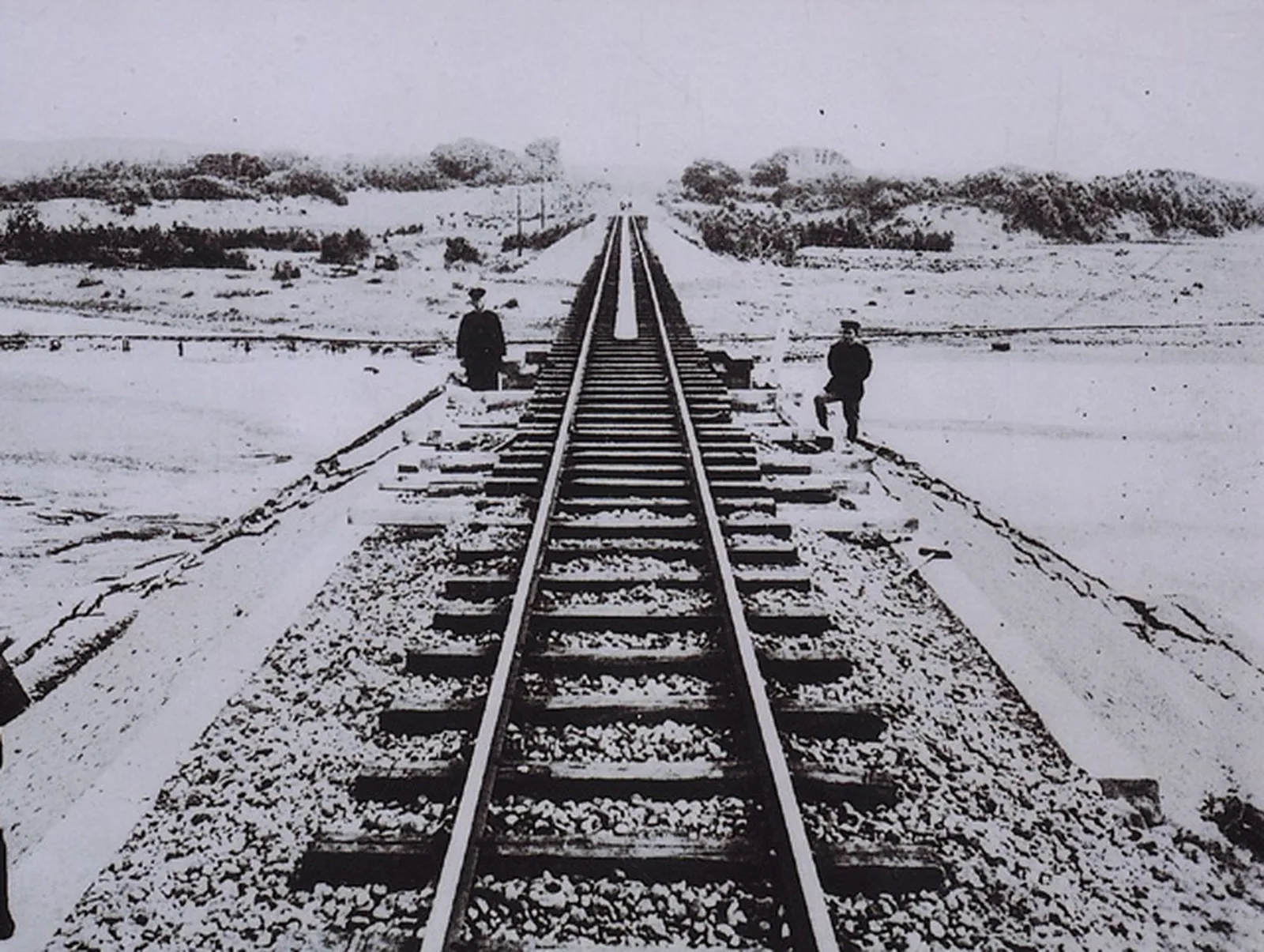
Image License: CC BY 3.0 TW+. Source: National Cultural Heritage Database Detail Page. The image is stored on this site according to the license, with no modifications to the image content.
The imagery connects the disaster area into a long strip, showing that the earthquake crossed roads, railways, fault lines, and administrative boundaries, forming a simultaneous local crisis. 1
Huang Wangcheng’s diary provides another way of reporting. He did not write official classifications first, but described brushing teeth, fleeing to a deep well, sweeping ash from the study, and roofs tilting with tiles flying. Lin Hsientang’s diary recorded that members of the Wufeng Lin family fell and were injured, chimneys were broken, tiles cracked, and mud-brick houses in the township collapsed. Both diaries deconstructed "home" into many parts that needed verification: whether people were injured, whether the roof was still there, whether doors and walls would fall, and whether family members dared to return to their rooms that night. 1 2
📝 Curator’s Note: Official reports are good at turning disaster situations into comparable fields; diaries preserve the chaos before those fields were formed. Placing them together prevents us from turning disaster victims into mere numbers for death, injury, or collapsed houses.
The Railway Broke, and Rescue Was Forced to Detour
Not only houses were damaged during the earthquake. Data from the coastal line preserved in the National Cultural Heritage Database records that between Zhuzi and Yuanli, road surfaces were damaged, embankments sank, roadbeds were hollowed out, and bridges were damaged, directly affecting railway operations. One year after the earthquake, the Taichung Earthquake Reconstruction Office of the Railway Department, Bureau of Transportation, Governor-General’s Office, published the Record of the 1935 Taiwan Earthquake (Showa 10), and later published the Record of the 1935 Taiwan Railway Earthquake, incorporating railway damage and repair into the earthquake record. 4
The terrain of the Jiushan Line was even more difficult to handle. The National Museum of Natural Science’s e-newsletter records that the 1935 earthquake severely damaged seven tunnels and three bridges on the Jiushan Line. The coastal line recovered traffic faster, while the Jiushan Line took about three years to repair. The Earthquake Reconstruction Monument near the old Taian Station today reminds people that the restoration of that railway required long-term engineering, causing prolonged traffic interruptions. 5
The breakage of the Yutengping Bridge later became the most visible earthquake relic.
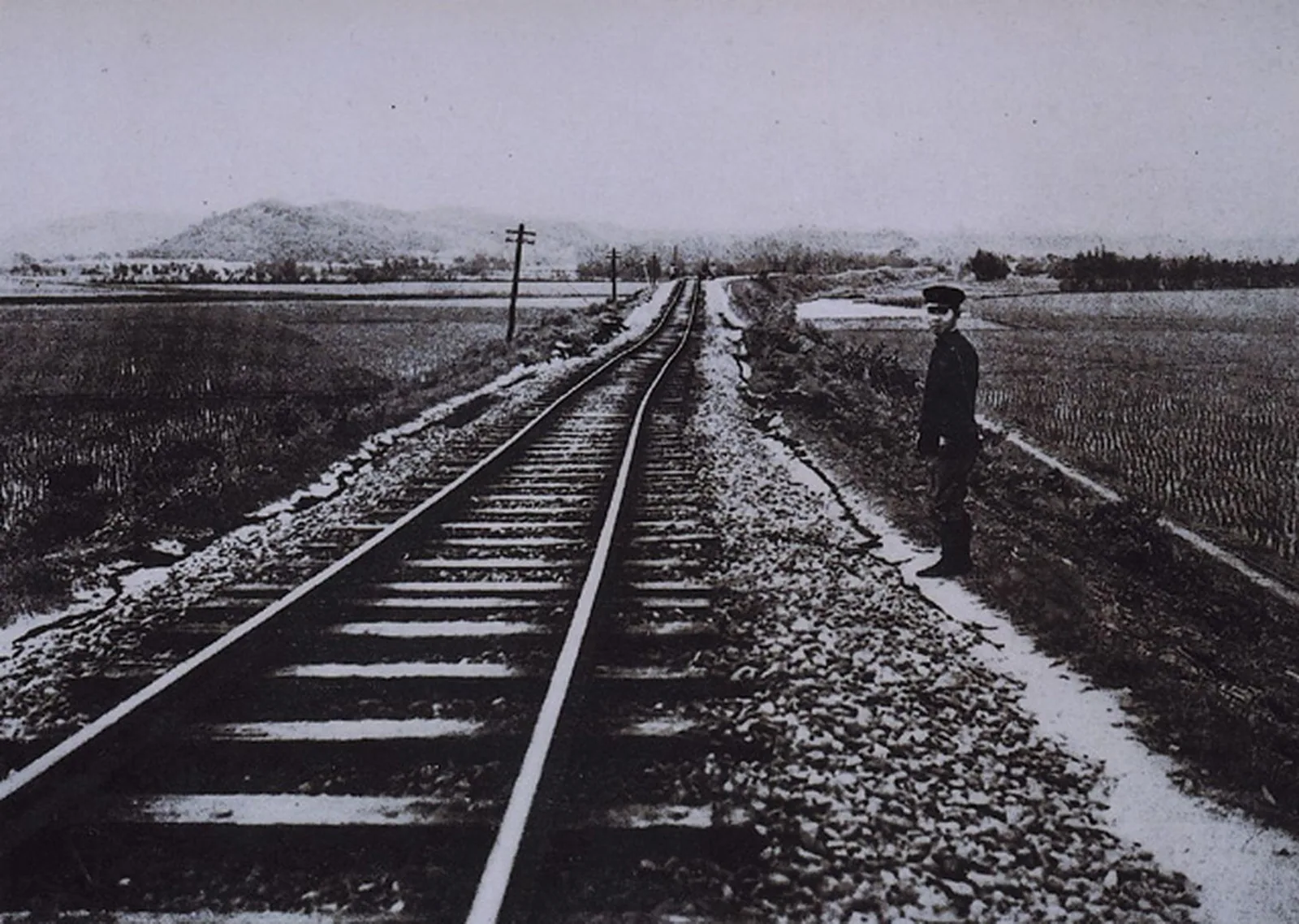
Image License: CC BY 3.0 TW+. Source: National Cultural Heritage Database Detail Page. The image is stored on this site according to the license, with no modifications to the image content.
It was originally part of the mountain line project of the trunk line. After the earthquake, only the bridge piers remained. The 1999 Jiji Earthquake damaged some of the piers again, so the same site stacked the memories of two earthquakes. Seeing the broken Yutengping Bridge as a scenic spot reveals ruins; placing it back into the transportation history of 1935 reveals how the bridge breakage delayed personnel, materials, and the reconnection of the locality. 2 5
Railway repair also had political significance. As the coastal line recovered faster while the mountain line was still under construction, transportation inequality was concretized into different speeds at which different localities received materials, news, and official inspections. Official reports recorded when which section opened for traffic; local memory remembered who came back first, where trains were still absent, and how to reach neighboring townships after roads were cut by cracks.
Reconstruction Committee: Restoring the Original State, or Redrawing the Streets?
Shortly after the earthquake, the Governor-General’s Office of Taiwan established the "Earthquake Disaster Reconstruction Committee." When introducing the Record of the 1935 Taiwan Earthquake (Showa 10), the Taiwan Literature and Archives Office of the Academia Sinica divided post-earthquake work into four parts: earthquake, disaster situation, rescue, and reconstruction. Reconstruction included not only repairing collapsed houses, but also urban planning reforms, tax reductions, self-reliance, and disaster relief. 3
The literal meaning of "urban planning reform" (Shiqu Gaizheng) is improving neighborhoods, but it actually included widening and straightening roads, drainage, public spaces, and building codes. Research from master’s and doctoral theses indicates that after the earthquake, the Governor-General’s Office designated multiple urban planning reform plans for streets in the central region, and observed how these plans affected the structure of street houses. This transformation could indeed reduce risks caused by narrow streets and non-earthquake-resistant houses, but it also redefined land boundaries, road setbacks, and how residents could rebuild their homes. 6
Mud-brick houses collapsed in large numbers during the earthquake, becoming a repeated subject of official discussion. Reducing the problem to "old houses are unsafe" is easy, but it ignores that the prevalence of mud-brick houses was related to material availability, family finances, rural life, and local construction methods. When the government prohibited or restricted certain building materials, safety standards conflicted with construction costs. Post-disaster planning not only raised earthquake resistance conditions for houses, but also decided which lifestyles could continue to exist.
📝 Curator’s Note: "Reconstruction" is often written as a story of cities becoming beautiful, but before roads become straight, someone must yield land; before houses become earthquake-resistant, someone must bear the cost of more expensive materials. Safety has never been an abstract goodwill without cost.
Urban planning reform also made the colonial government’s governance capacity visible. The government transformed the disaster area into a manageable space through surveying, maps, road plans, and building combinations. This system could mobilize funds and professionals, but it could also compress local choices into engineering standards. Post-disaster construction therefore had both protective and controlling aspects; it cannot be dismissed with the three words "modernization."
After the Earthquake, the Observation System Began to Grow
The 1935 earthquake exposed the inadequacies of Taiwan’s earthquake observation and disaster reporting. The Central Weather Bureau article points out that within a month after the strong earthquake, there were over 60 felt earthquakes, damaging the island’s telecommunications, telephones, railways, bridges, and roads. The earthquake process did not end with one shake; aftershocks, earth sounds, road blockages, and rumors extended the crisis. 2
At the time of the earthquake, rumors also spread locally. The Central Weather Bureau recorded that the Governor-General’s Office required all prefectures and counties to suppress rumor spreaders; Hsinchu and Taichung Prefectures together suppressed 14 incidents. Some rumors connected the earthquake with the postponement of Mazu’s procession; some predicted an even larger earthquake before midnight; some even impersonated the observatory to issue notices, causing residents to sleep outdoors. The official handling of rumors showed that disaster information itself was part of governance. When railways were cut, telephones were down, and local offices each held fragmented news, whoever could release credible news controlled part of the post-disaster order. 2
After the earthquake, the Governor-General’s Office added or strengthened earthquake observation equipment and planned earthquake research and observation facilities in Hsinchu Prefecture. Central Weather Bureau data indicates that the Hsinchu Observatory later focused on island-wide earthquake activity and earthquake forecasting, opening in 1938. This path turned one earthquake into instruments, observatories, reports, and professional training. 2 3
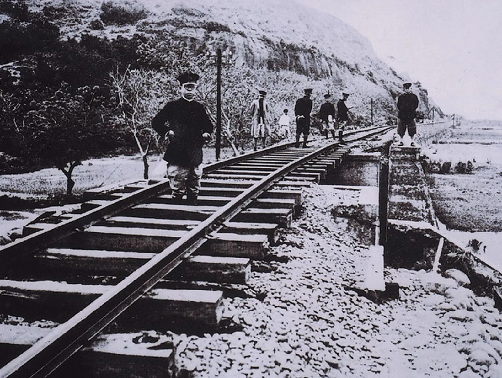
Image License: CC BY 3.0 TW+. Source: National Cultural Heritage Database Detail Page. The image is stored on this site according to the license, with no modifications to the image content.
However, an observation system does not mean prediction ability matured immediately. People in 1935 still could not know which aftershock would cause greater harm, nor could they use modern mobile phones to transmit the scene back to the center. What observatories could do was accumulate data, measure seismic direction, organize epicenters and aftershocks, and gradually turn "the earth bull turning over" into a comparable seismological object.
Earthquake Charity Concerts: Music as a Rescue Route
Post-disaster relief was not limited to police, hospitals, and engineering units. Data from the "Earthquake Charity Concert" preserved in the Academia Sinica Archives shows that Cai Peihuo initiated a touring concert to relieve disaster victims. The Central Weather Bureau’s special topic records that this activity toured 31 locations in 42 days, penetrating rural areas, becoming an early Western music touring performance in Taiwan’s music history that deeply reached rural areas. 7 2
This event is easily written as a touching interlude, but it was actually a form of social mobilization. Musicians had to move to different places; local organizations needed to provide venues and promotion; audiences turned a performance into relief resources through donations. The earthquake made railways and roads unstable, yet the charity activity still tried to connect cities and rural areas along the transportation network.
It also reminds us that post-disaster society was not limited to two roles: victims and government. Local gentry, social activists, female musicians, schools, and civil groups could all participate in rescue. These actions did not necessarily detach from the colonial government’s framework, but they ensured that disaster victims were not only waiting for treasury allocations or official orders, but could enter the relief scene with their own organizations and voices. The official Earthquake Record also recorded hospitals, police officers, and civil groups forming rescue teams; these teams handled the injured, transported materials, and provided temporary shelter, making disaster relief a work crossing administrative and local networks. 3
📝 Curator’s Note: The significance of the charity concert is not just "soothing hearts with music." It turned cultural activities into a collaboration of transportation, fundraising, and local organization, allowing post-disaster publicness to grow not only from government offices.
What of 1935 Is Still Visible Today
Some relics of the 1935 earthquake are conspicuous, such as the broken Yutengping Bridge and the monument near the old Taian Station. Others are not easily seen, such as a wider street, a reconfigured drainage system, a road straightened on a map, or a seismic observation system that later became commonplace. If public memory only leaves photos of broken bridges, it forgets that post-disaster reconstruction actually transformed more daily spaces. 4 5
UTS’s public history research views the 1935 earthquake as a case of disaster sites and public memory. This perspective helps us understand that sites are not transparent evidence left naturally. People choose which bridge to preserve, which village to commemorate, and which photo to display; this is also a choice of how to explain the disaster. When the earthquake is placed into monuments, local exhibitions, digital archives, and school textbooks, the past returns to the present in different forms. 8
For today’s readers, the most important question of 1935 is not "whether we are more advanced than then." More worth asking is: when we talk about disaster prevention, earthquake resistance, and reconstruction today, do we still treat safety as a standard decided unilaterally by professionals? The 1935 urban planning reform made streets more orderly, but did not necessarily allow all residents to participate equally. The 1935 observation system increased knowledge, but could not bear the cost of relocation and loss of homes for localities.
At 6:02 a.m. on April 21, 1935, Huang Wangcheng waited by the well for the shaking to stop; Yang Zhaojia sent Qingshui into the administrative gaze with a business card. Subsequent statistical tables, railway repair maps, urban planning reform plans, and observatories were all institutions that grew from these chaotic scenes. They made Taiwan better able to recognize earthquakes, and allowed local life to be rearranged into the national map. A new road on the map, a monitoring station in a report, a section of drainage next to a house—all are results of technical choices and power relations.
Therefore, what this earthquake left behind is not a single conclusion. Local administrative statistics, engineering unit repairs, observatory instruments, and residents’ diaries each preserve part of the scene. Reading these materials side by side reveals that "post-disaster" actually continued for many years. How roads were built, how houses were constructed, how information was transmitted, and how memory was preserved were all repeatedly decided after the earthquake.
Walking today in Qingshui, Houli, Miaoli, or along the Jiushan Line, one may not directly see the 1935 epicenter. But road width, railway relics, monuments, and archive images still bring that morning back. They remind us that institutions left by disasters do not automatically become fair. Disaster prevention is not just reinforcing buildings before the next earthquake. Affected people should also participate in deciding what needs to be preserved, what must change, and who bears the cost of change. For 1935, this question also includes who can be seen by official reports, whose homes remain only statistical numbers, and how local residents continue to explain what they have lost after reconstruction. If local archives can be cross-checked with on-site walking and family memories, disaster history will not remain only from an official perspective.
Further Reading
- The Great Earthquake in Taiwan (Part 1): Detail page of earthquake disaster historical materials from the Digital Collection of the Taiwan History Institute Archives, Academia Sinica.
- Photos Related to the 1935 Taiwan Earthquake (Part 1): Detail page of post-disaster images preserved by the Taiwan History Institute Archives, Academia Sinica.
- Huang Wangcheng’s Diary, 1935: Detail page of the digital collection of Huang Wangcheng and Huang Jitu’s documents. It is both the number 3,279 deaths and the family members afraid to go home by the deep well. It is both the broken iron bridge and the wider streets after reconstruction. It both promoted observation and disaster prevention, and allowed us to see who planned safety and who bore the cost of transformation. The earthquake has long stopped, but the question continues to vibrate in streets, bridge piers, archives, and memory.
References
- Heaven and Earth Shaking at Dawn: Taiwan History Institute Archives, Academia Sinica.
- In the Morning Light, Violent Shocks Strike: The 1935 Hsinchu-Taichung Great Earthquake: Southern District Meteorological Center, Central Weather Bureau.
- The Record of the 1935 Taiwan Earthquake (Showa 10): E-Newsletter, Taiwan Literature and Archives Office, Academia Sinica.
- Coastal Line Disaster Conditions from the Great Earthquake in Central Taiwan in Showa 10: National Cultural Heritage Database.
- Impact of 1935 Post-Earthquake Urban Planning Reform on the Structure of Street Houses in Central Taiwan: Taiwan Master’s and Doctoral Theses Knowledge Value-Added System.
- Earthquake Charity Concert: Female Musicians Demonstrating Humanitarian Spirit: Taiwan History Institute Archives, Academia Sinica.
- Unexpected Discovery in Spring Tour: The Earthquake Reconstruction Monument at the Old Taian Station: National Museum of Natural Science E-Newsletter.
- The Record of the 1935 Taichung Prefecture Earthquake (Showa 10): PDF Collection, National Taiwan Library.
- The 1935 Hsinchu-Taichung Earthquake: Natural Disasters as Public Memory: Public History Review.
- Japanese Soldier Lao Gu: Hsinchu-Taichung Earthquake, Hualian Sugar Industry, and Guanghua Farm: 1937-1949 Era Link.
- Post-Disaster Conditions of the 1935 Hsinchu-Taichung Earthquake: National Cultural Heritage Database. Photo source: Huang Ronglu. Creator and filing unit: Hsinchu City Cultural Bureau. Digital object license: CC BY-NC 3.0 TW+.
- Heaven and Earth Shaking at Dawn — Taiwan History Institute Archives, Academia Sinica article, verifying the 1935 earthquake time, epicenter, casualty overview, Yang Zhaojia’s "Qingshui Wiped Out" business card, post-disaster images, and Huang Wangcheng and Lin Hsientang’s diaries.↩234567
- In the Morning Light, Violent Shocks Strike: The 1935 Hsinchu-Taichung Great Earthquake — Central Weather Bureau article, verifying magnitude caliber, housing and casualty statistics, aftershocks, earth sounds, rumor suppression, observation system, Cai Peihuo’s charity concert, and urban plans.↩23456789101112
- The Record of the 1935 Taiwan Earthquake (Showa 10) — Taiwan Literature and Archives Office, Academia Sinica article, verifying the publication of the official Earthquake Record, the Earthquake Disaster Reconstruction Committee, rescue, reconstruction, urban planning reform, and observation system.↩234567
- Coastal Line Disaster Conditions from the Great Earthquake in Central Taiwan in Showa 10 — National Cultural Heritage Database detail page, verifying coastal line railway road surfaces, embankments, and bridge damage, as well as post-earthquake railway reconstruction publications. Page data license is CC BY 3.0 TW+.↩2
- Unexpected Discovery in Spring Tour: The Earthquake Reconstruction Monument at the Old Taian Station — National Museum of Natural Science E-Newsletter, verifying Jiushan Line tunnel and bridge damage, coastal line and mountain line repair times, and the Taian Station monument.↩23
- Impact of 1935 Post-Earthquake Urban Planning Reform on the Structure of Street Houses in Central Taiwan — Taiwan Master’s and Doctoral Theses Knowledge Value-Added System research detail page, verifying post-earthquake urban planning reform plans and changes in central Taiwan street house structures.↩
- Earthquake Charity Concert: Female Musicians Demonstrating Humanitarian Spirit — Taiwan History Institute Archives, Academia Sinica article, verifying Cai Peihuo, the 1935 earthquake, and the earthquake charity concert.↩
- The 1935 Hsinchu-Taichung Earthquake: Natural Disasters as Public Memory — Public History Review academic article, verifying the research framework of disaster sites and public memory.↩