30-second overview: Hualien County covers 4,628 square kilometers, making it Taiwan’s largest county by area. It runs 137.5 kilometers north to south; at its narrowest point, only 5 kilometers separate the Central Mountain Range from the Pacific Ocean. On this thinnest strip of land between mountains and sea live six Indigenous peoples: Amis, Truku, Sakizaya, Seediq, Bunun, and Kavalan. After the Kalyawan Incident of 1878, the Sakizaya hid within the Amis for 129 years, and were recognized as the 13th Indigenous people only on January 17, 2007, during the Chen Shui-bian administration’s second term. The Truku, meanwhile, separated from the Atayal classification on January 14, 2004, becoming the 12th. On August 17, 1986, Tzu Chi Hospital opened in Xincheng Township, only a few steps from the bishop wood tree where the chief had once been executed by lingchi. At 7:58 a.m. on April 3, 2024, a magnitude 7.1 earthquake, initially measured at 7.2, struck with its epicenter in Shoufeng Township. Taroko National Park is estimated to need seven years to recover. In 2024 it received 210,000 visitors; in normal years, 6.6 million. This article’s point is this: all of Hualien’s beautiful landscapes were bought with millions of years of the earth’s shaking; every ethnic name was recovered through generations of living under concealed identities.
The Lost Lake of Qixingtan
If you ask an elderly person in Xincheng Township why Qixingtan is called “Qixingtan,” they will not point to the crescent-shaped pebble bay in front of you. They will point inland, toward today’s Hualien Airport runway.
The “tan” in Qixingtan originally meant a lake, not the sea. Before 1936, east of today’s Hualien Airport there was a north-south chain of lakes shaped like the Big Dipper, so it was called “Qixingtan,” or Seven Star Lake.1 In 1936, during Japanese rule, the Governor-General’s Office wanted to build Hualien Harbor North Airfield, today’s Hualien Airport, and filled in these lakes. The residents who had lived by the lakes were relocated to the Pacific coast. They brought the old place name with them.1
So when tourists today pick up stones on Qixingtan Beach and watch the waves in the direction of Guishan, the “Qixingtan” they see is in fact a bay, not a lake. An inland place name that disappeared in 1936 was reused for a coastal attraction that appeared after 1936. It is one of Taiwan’s rare cases of “a place name being misplaced onto a tourist site.”
This story works well as Hualien’s opening. Beneath almost every tourist place name in Hualien lies a layer of rewritten history. To outsiders, Taroko is a tourist attraction; to the Truku, it is the home they settled in after crossing the mountains from Nantou 300 years ago.2 The bishop wood tree beside Tzu Chi Hospital marks the place where Qing troops executed the Sakizaya chief Komod Pazik by lingchi in 1878.3 Even many Japanese-style neighborhoods in central Hualien City began as Yoshino Village, Toyota Village, and Hayashida Village, settlements created by the Governor-General’s Office in 1913.4
Outsiders see Hualien as Taroko plus Qixingtan plus Tzu Chi. Locals know that every inch of this 4,628-square-kilometer land has two layers of names.
A Five-Kilometer Crack Between Mountains and Sea
To understand how Hualien can simultaneously hold six Indigenous peoples, Taiwan’s largest NGO, and Taiwan’s largest inland earthquake, one must first look at the shape of the land.
Hualien County covers 4,628.57 square kilometers, the largest county area in Taiwan and one-eighth of the country’s total area. It is 137.5 kilometers long from north to south, roughly the straight-line distance from Ruifang in New Taipei City to Houlong in Miaoli County. Yet at its narrowest east-west point, from the ridge of the Central Mountain Range to the Pacific surface, it is only around 5 kilometers wide, along the Qingshui Cliff section.5
That ratio is abnormal. A county 137.5 kilometers long but only 5 kilometers wide at its thinnest is like compressing all of Taiwan into a long, thin strip and then standing it on the edge of a tectonic plate.
The shape comes from the “Penglai Orogeny” that began 6 million years ago. The Philippine Sea Plate collided from south to north and east to west with the margin of the Eurasian Plate, pushing the island of Taiwan up from the seafloor. Hualien sits precisely on this collision zone: the Central Mountain Range to the west, including Yushan, Qilai Main Peak, and Nanhu Mountain; the East Rift Valley in the middle, 3 to 9 kilometers wide, the suture zone between the Philippine Sea Plate and the Eurasian Plate; the Coastal Mountain Range to the east; and beyond that, the Pacific Ocean.5
The Taroko National Park Headquarters summarized the story of the Liwu River cutting through marble in one sentence: “About 6 million years ago, the Philippine Sea Plate began colliding with the margin of the continental plate... the Liwu River appeared, and happened to flow across this thick marble layer. Like a sharp blade, the Liwu River’s water continually eroded downward. The wondrous Taroko Gorge slowly formed over millions of years through the two forces of plate uplift and river downcutting.”6 The marble itself can be traced back 250 million years, when biological shells were deposited in the shallow Pacific, mixed with volcanic ash, and later transformed by metamorphism.
The plates keep shaking. On October 22, 1951, the first earthquake in the East Rift Valley earthquake series, ML 7.3, struck offshore southeast of Hualien City, killing 85 people, severely injuring 200, and lightly injuring more than 1,000.7 On November 25 of the same year, a second ML 7.3 quake struck, damaging the Yuli area. On November 15, 1986, an undersea ML 6.8 quake east of Hualien killed 15 and injured 62; the Suhua Highway and Central Cross-Island Highway were both completely cut off, and the North-Link Railway’s tracks twisted. At 7:58 a.m. on April 3, 2024, an ML 7.1 quake became Taiwan’s largest inland earthquake since the 1999 921 earthquake.8
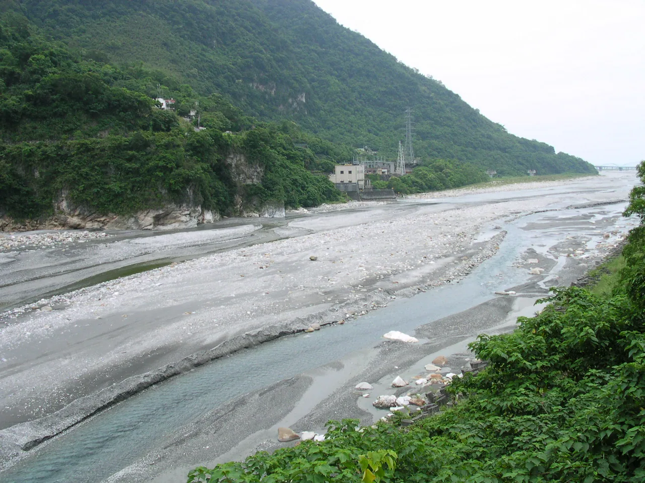
The Liwu River, Taroko National Park. Photo: Vegafish, CC BY-SA 2.5 via Wikimedia.
The rain also keeps falling. Eastern Hualien faces the Pacific, and Hualien is often the first place typhoons make landfall from the east. In summer, southwesterly flows are forced upward by the Central Mountain Range, squeezing rain out over the mountains. In autumn and winter, the northeast monsoon carries Pacific moisture into the East Rift Valley. Annual rainfall is around 2,500 millimeters on the plains, while mountain townships such as Xiulin and Wanrong often exceed 4,000 millimeters. In 2024, the place with the most rainy days in Taiwan was Xiulin Township, Hualien, with 334 days.9 Typhoon tracks, monsoons, and high mountain terrain overlap in Hualien.
Mountains make up 85% of the county; plains and river terraces only 15%.5 A population of 320,000 is pressed onto that 15%, mainly distributed along the East Rift Valley. The Indigenous population is 94,134, as of the end of 2024, accounting for 29.8% of the county, the highest proportion in Taiwan.10
The Bishop Wood Tree of 1878
To understand why the Sakizaya lived under concealed identities for 129 years, one must begin on the morning of June 18, 1878.
That day, Kavalan people from Kalyawan, today’s Jiali Village in Xincheng Township, intercepted documents related to grain being transported by Qing soldiers.3 There are two explanations for the cause: one says that a Han merchant, Chen Wenli, had illegally occupied Kavalan land, and Qing soldiers sided with the Han when they intervened; another says that Qing soldiers harassed women while driving away merchants.3 The next day, June 19, the Kavalan joined forces to surround the Quezilong Battery, in today’s Jiali and Beipu area, wounding Qing deputy general Chen Desheng and killing Qing officer Yang Yugui.
The Sakizaya community of Takubuwan, in today’s Hualien City area, had been neighbors with Kalyawan for generations. Chief Komod Pazik decided to join the battle.
The Qing counterattack came quickly. Sun Kaihua, the Fujian land-route provincial commander-in-chief, advanced south from the north and attacked Takubuwan with fire. The community was destroyed. The Chinese Wikipedia entry records what followed: “After the Sakizaya surrendered, Qing troops bound Komod Pazik to a bishop wood tree near today’s Hualien Tzu Chi Hospital and executed him by lingchi.” “After Takubuwan was breached, the two peoples suffered near extermination. Survivors fled to the Rift Valley and the east coast, hiding among the Amis until name rectification succeeded in 2007.”3
“Lingchi” was one of the cruelest punishments of the Qing era, a slow cutting by hundreds of slices. As Komod Pazik was executed beneath that tree, the Sakizaya also made a collective decision at the level of the people: those who survived would henceforth say they were Amis.
📝 Curator’s note: When a people chooses to conceal its name for 129 years, from 1878 to 2007, it is not because they forgot who they were. It is because remembering hurt too much. During Japanese rule, the Japanese classified the Sakizaya as the “Kilai branch of the Amis.” After 1949, the Kuomintang government inherited this classification and did not change it. A 2007 special feature in Taiwan Panorama put this concealment very directly: “In 1878, the ‘Kalyawan Incident’ occurred. The Sakizaya were defeated, causing community members to scatter and migrate; in addition, during the Japanese period, to escape forced labor and floods, they became even more displaced, and from then on concealed their identities beneath Amis communities.”11 Today Tzu Chi Hospital, which opened in 1986, happens to stand near the bishop wood tree where the lingchi execution took place: one people’s most modern Taiwanese medical landmark sits beside another people’s deepest historical wound. Geography has stacked two times on the same address.
In July 1990, the late elder Tiway Sayun, Chinese name Li Laiwang, held a collective ancestral rite on the banks of Hualien City’s Meilun River and launched the name-rectification movement.11 On July 1, 2006, after a suspension of 128 years, the Sakizaya resumed holding the Palamal Fire God Festival in Hualien City’s Guofu community to commemorate the Kalyawan Incident.11 On January 17, 2007, the Executive Yuan, during the Chen Shui-bian administration’s second term, formally recognized the Sakizaya as Taiwan’s 13th Indigenous people. (⚠️ The Stage 0 note mistakenly wrote “Tsai Ing-wen administration.” In 2007 Tsai Ing-wen had not yet served as president; the administration that recognized the name was Chen Shui-bian’s.)11
Walis Pelin, then minister of the Council of Indigenous Peoples, told Taiwan Panorama: “Ethnic recognition mainly relies on the wishes of each people’s communities, as well as particularities of language, religion, culture, and so on. The Sakizaya were able to become Taiwan’s 13th Indigenous people not only because ethnic will was high, but also because the Sakizaya have a distinctive language and culture; only then could name rectification succeed.”11
_Sakizaya Fire God Festival opening rite, 2017-09-24. Photo: Tokoabibi, CC BY-SA 4.0 via Wikimedia._
In 1914, Governor-General Sakuma Brought in 11,075 People
During the same period when the Sakizaya hid their name, the Truku, on the other side of the mountains, were preparing to face another army.
The Truku crossed the mountains from Nantou 300 years ago. They share common ancestors with the Seediq, both belonging to the Seediqic language group. About 300 years ago, some migrated east from the area of today’s Ren’ai Township in Nantou to Hualien, settling in the Liwu River basin.2 During Japanese rule, the Japanese government classified all related peoples uniformly as “Atayal,” absorbing both the Truku and the Seediq into that category.
In 1896, the Xincheng Incident took place: Japanese garrison soldiers sexually assaulted Truku women, and the Truku launched a surprise attack, killing 13 officers and soldiers. This became the starting point of Truku resistance to Japan.12 Conflict continued between the two sides for more than a decade.
1914 was the year of confrontation. Sakuma Samata, the fifth governor-general of Taiwan, had already been implementing his Five-Year Plan to Govern the Aborigines, from 1910 to 1915, for four years. The Truku were the last mountain people not yet subdued. On May 14, 1914, Governor-General Sakuma appointed himself commander of the punitive expedition. On May 17, he ordered the campaign.12
The scale of Japanese mobilization was rare in Taiwan’s history of anti-Japanese resistance: 6,235 military and police personnel, and 11,075 people in total including miscellaneous laborers.12 This was more than three times the Truku adult male fighting population, which was around 3,000.
The Truku fought by different methods. Historical materials record that they used “traditional hunting methods, traps, falling rocks, adept use of strongholds, terrain, landforms, camouflage and concealment, night operations, ambushes, guerrilla warfare, surprise attacks, flanking maneuvers, and other tactics.”12 On July 3, 1914, the Truku paramount chief Holok-Naowi led his people to lay down their weapons and submit. Postwar Japanese statistics recorded 138 police casualties and 226 military casualties.12 On the Truku side, multiple sources record “more than 330” deaths. (⚠️ This figure appears mostly in secondary citations and lacks precise verification from primary documents.12)
After the war, the Truku were forcibly subjected to “group relocation,” moved down from their traditional communities in the upper Liwu River and scattered across the foothills of the East Rift Valley. Place names such as today’s Datong, Dali, and Jiawan communities are all results of resettlement after 1914.
The migration story of the Bunun connects to this forced relocation policy. The Bunun originally lived in the Zhuoshui River basin in Nantou County, in Xinyi and Ren’ai townships, and were divided into five major communities: Takituduh, Takibakha, Takbanuaz, Isbukun, and Takopulan.13 From 1904 onward, the Japanese colonial government promoted “group relocation,” forcing deep-mountain communities to concentrate near police outposts. In the late 1930s, during the first phase of the Kominka movement, 1936 to 1940, this process accelerated, and large numbers of Bunun from Nantou were relocated to Yuli and Zhuoxi in Hualien.13
“1937” is often cited as the symbolic year for this migration, but it is more precise to describe it as a series of migrations from the 1930s into the 1940s. (⚠️ A single-year assertion is inaccurate.)13 Today in Zhuoxi Township, the Bunun Pasibutbut, an eight-part polyphonic song praying for a millet harvest, in which men sing in a circle across eight different pitches, has been listed as a Hualien County cultural asset.13 The homeland of this musical form was Nantou, but the place where it has been preserved intact into the present is the next stop after forced migration.
The Hospital Built Beside the Lingchi Tree in 1986
To understand why Taiwan’s largest NGO emerged in Hualien, one must return to the medical conditions of 1960s Hualien.
In 1964, a 29-year-old Buddhist nun, Dharma Master Cheng Yen, born Wang Jinyun in Qingshui, Taichung, in 1935, stayed with her disciples at Puming Temple and lived a life of farming and study.14 On May 14, 1966, the 24th day of the third lunar month, the Buddhist Compassion Relief Tzu Chi Merit Association was formally established in Hualien. That same year, the master’s lay mother, Wang Shen Yuegui, paid for land near the present site of the Jing Si Abode. In 1968, the land was used as collateral for a bank loan to build the Jing Si Abode, whose main hall adopted Tang-style architecture. In 1969, the Jing Si Abode was completed and opened in Kangle Village, Xincheng Township, Hualien County.14
In the beginning there were 30 female believers, or “senior sisters,” who saved 50 cents each day in bamboo coin banks. They spread the slogan in the market: “We save 50 cents every day! We have a relief association to help others!”14 The bamboo bank years were later written by Tzu Chi itself into a founding myth. The Jing Si Abode continues to follow the spirit of “No work, no meal”; monastics support themselves by producing handmade foods such as Xiangji tofu and Jing Si noodles in exchange for income.15
But the key that took Tzu Chi from a Hualien abode to an international NGO was the hospital.
In the 1960s, Hualien did not even have adequate public hospitals, and seeking medical treatment in eastern Taiwan was difficult. To send a critically ill patient from Hualien to Taipei meant relying on road or sea transport, and the time spent on the way often meant the difference between life and death. On May 10, 1979, Master Cheng Yen announced the plan to build a hospital. Ground was broken on February 5, 1983. On August 17, 1986, Hualien Tzu Chi Hospital officially opened,14 not in 1991. (⚠️ This is a commonly confused year.) Tzu Chi did establish other undertakings in 1991, but the hospital’s precise opening year was 1986. In 2002, Tzu Chi Hospital was upgraded to eastern Taiwan’s only medical center.
The geographic coincidence is astonishing. The area around Kangle Village in Xincheng Township, where the Jing Si Abode and Tzu Chi Hospital are located, is historically the area around the bishop wood tree where Qing troops executed the Sakizaya chief Komod Pazik in 1878.3 One people’s most painful memory and another faith system’s largest relief project are layered on the same land, separated by more than a century.
✦ “Why was Taiwan’s largest NGO born in 1960s Hualien, an eastern region without even a complete public hospital? Because lack is the starting point of compassion.”
Today Tzu Chi holds NGO consultative status, operates a disaster-relief network covering more than 130 countries, runs Tzu Chi University and Tzu Chi University of Science and Technology in Hualien, and maintains four missions: charity, medicine, education, and humanistic culture. But what Hualien people remember is that before that day in August 1986, their nearest medical center was 300 kilometers away.
Tzu Chi Jing Si Hall, Hualien City, 2009. Photo: Fred Hsu, CC BY-SA 3.0 via Wikimedia.
One County Returned Two Names to Peoples
On January 14, 2004, the Executive Yuan approved the Truku as Taiwan’s 12th Indigenous people.2 Counting from their classification as “Atayal” during Japanese rule, they had waited a century to take their name back.
Teyra Yudaw, secretary-general of the Truku Name Rectification Association, later left one sentence in an interview with The Reporter: “The name ‘Taroko’ is the best gift our people have given Taiwan.”16
In the Truku language, Truku means “a platform on the mountainside,” “a place suitable for living,” and also a “place of lookout” to guard against enemy raids.2 The people are concentrated mainly in Xiulin Township, including Taroko Gorge, Wanrong Township, parts of Zhuoxi Township, and Qingfeng, Nanhua, and Fuxing villages in Ji’an Township. Taiwan’s Truku population is around 29,847.
On January 17, 2007, the Sakizaya were recognized under their own name as the 13th Indigenous people, as discussed above. The 129 years of concealed identity finally ended.
On April 23, 2008, the Seediq were recognized as the 14th Indigenous people.17 They are the branch that shares origins with the Truku but remained in Nantou. On December 25, 2002, the Kavalan had already been recognized as the 11th Indigenous people.18 They are a Pingpu people who migrated south from the Lanyang Plain of Yilan to Hualien in the 1830s, and they were the other protagonist of the 1878 Kalyawan Incident.
So today Hualien County is home to six officially recognized Indigenous peoples, not five. (⚠️ This is a common simplification.)
- Amis: Taiwan’s largest Indigenous people, with 220,000 people, and the largest Indigenous group in Hualien. Northern Nanshi Amis live in Xincheng, Hualien City, Ji’an, Shoufeng, and Fenglin; southern coastal Amis live in Fengbin and around the Xiuguluan River mouth. The harvest festival, Ilisin, is mainly held each August and is Taiwan’s largest Indigenous festival.17
- Truku (recognized in 2004, the 12th people): Xiulin, Wanrong, and parts of Zhuoxi. Traditions include facial tattooing, Ptasan, and the ancestral law Gaya.
- Sakizaya (recognized in 2007, the 13th people): Xincheng and Ruisui area. The Fire God Festival is held every year on the first Saturday of October.
- Seediq (recognized in 2008, the 14th people): parts of Wanrong Township, sharing origins with the Truku.
- Bunun: Yuli Township and Zhuoxi Township. Migrated from Nantou in the 1930s and 1940s. Known for eight-part polyphony.
- Kavalan (recognized in 2002, the 11th people): Jiali Village in Xincheng Township and Xinshe Village in Fengbin Township. Migrated from Yilan in the 1830s and 1840s.
Teyra Yudaw said another sentence to The Reporter: “At present there is no cultural tourism; it is relatively purely natural landscape. But for a place to develop tourism, it cannot rely only on natural resources. It should also take humanistic resources into account, only then can it have richness and vitality.”16 Spoken the year before the 0403 earthquake, this sentence now reads like a prophecy.
Toyota in 1913, the North-Link Railway in 1980, the Suhua Improvement in 2020
The Han story in Hualien began much later than in Qing-ruled western Taiwan. In 1875, under Shen Baozhen’s policy of “opening the mountains and pacifying the aborigines,” Luo Dachun supervised construction of the “northern route” from Su’ao to Qilai, today’s Hualien. This was the prototype of the Suhua Historic Trail.19 But what truly connected Hualien with the north were three waves of construction during Japanese rule.
The first wave was the immigrant villages of 1913. The Japanese colonial government promoted a “free immigration” policy, recruiting Japanese farmers from Hokkaido and Shikoku to establish government-run immigrant villages in Hualien: Toyota Village, today’s Shoufeng Township, received its first settlers in July 1913, 179 households and 866 people. The village used a grid street plan, and each household was allocated a 441-ping house lot and courtyard plus 3 jia of farmland.4 Yoshino Village, today’s Ji’an Township, was established beside Hualien City. Hayashida Village, today’s Darong and Beilin villages in Fenglin Township, later became the area with Taiwan’s highest density of tobacco barns. The three villages together had about 3,386 settlers. After the war, Japanese residents left, the land was taken over by benshengren, or Taiwanese whose families were in Taiwan before 1945, and Toyota Village transformed into a mainly Hakka migrant settlement. Lintianshan Forestry Culture Park was once called “Hualien’s Little Jiufen.”4
The second wave was the marble industry. Hualien’s marble deposits are estimated at 300 billion metric tons, the source of white, gray, and black marble as well as serpentinite. From the 1960s, mines expanded in northern Hualien: Heping, Hezhong, Heren, the Taroko entrance, and Sanzhan.20 The stone-processing industry has an annual output value of NT$21 billion to NT$31 billion, and Hualien’s upstream and downstream workforce numbers around 15,000 people, roughly one-tenth of the county’s total labor force. Asia Cement entered Xincheng Mountain in 1975 to mine limestone for cement raw material. The mining area sits at the entrance to Taroko National Park, on the south bank of the Liwu River, later triggering the “Oppose Asia Cement, Return Our Land” movement, which continued unresolved into 2026.20
The third wave was the North-Link Railway. Construction began on December 25, 1973, and was listed among the Ten Major Construction Projects. The full line opened on February 1, 1980. Investment totaled NT$7.3 billion, and construction took six years. Before the line opened, traveling from Taipei to Hualien required first going to Su’ao and transferring to a Taiwan Motor Transport bus on the Suhua Highway, or taking a passenger ship from Keelung to Hualien; the whole trip took about 18 hours. After the line opened, the North-Link Railway compressed the journey to around 5 hours.21 In the same year the North-Link Railway opened, tourism in Hualien began to surge from the 1980s onward.
The Suhua Highway itself has also evolved through three generations. The first was Shen Baozhen’s Suhua Historic Trail of 1875. The second was the modern 119-kilometer Suhua coastal road completed by Japan in 1932, then known as “the world’s most dangerous road.” The third was the completion of two-way traffic on the Suhua Highway in 1990. On February 5, 2018, the first section of the Suhua Highway Improvement Project, from Su’ao to Dong’ao, opened. On January 6, 2020, the Nan’ao-to-Heping section and the Hezhong-to-Daqingshui section opened, completing the full Suhua Improvement Project.22 It is 38.8 kilometers long, comprising 8 tunnels totaling 24.6 kilometers, 13 bridges totaling 8.6 kilometers, and 5.6 kilometers of surface roads, replacing the most dangerous “nine bends and eighteen turns” section. The Suhua Safety Improvement Project, scheduled to begin construction in 2025 and target completion in 2032, will address another 29.9 kilometers not covered by the Suhua Improvement Project.22
📝 Curator’s note: Hidden in the century-plus evolution of the Suhua Highway is an axis measuring Hualien’s “distance from the world.” The 1875 Suhua Historic Trail took several days to walk. The 1932 coastal road made one-day travel possible, but could be severed at any moment by rockfall or earthquake. The 1980 North-Link Railway took 5 hours. The 2020 Suhua Improvement took 1 hour. Behind every generation of shortened distance lay a trade between engineering and death: 26 kilometers of the Suhua Improvement itself run inside mountains, and groundwater inflow and rockfall in the more than 4-kilometer Heren Tunnel alone cost several lives. But after 7:58 a.m. on April 3, 2024, this road broke again. The earthquake made 145 years of engineering history from 1875 to 2020 prove one thing: humans can shorten distance, but not enough to make the earth stop shaking.
The Open-Cut Tunnel at Swallow Grotto Collapsed in 98 Seconds
Time: 7:58:09 a.m., April 3, 2024.
Epicenter: Shoufeng Township, Hualien County, 23.88°N, 121.57°E.
Depth: 19.7 kilometers.
Magnitude: the Central Weather Administration initially measured ML 7.2; on February 1, 2025, it revised and confirmed ML 7.1.
Maximum intensity: 6-upper at Heping Village, Xiulin Township, Hualien County; shaking lasted about 98 seconds.8
What does 98 seconds mean? A song’s chorus is about 30 seconds. When a mainshock lasts longer than 30 seconds, people begin to wonder whether this is the end of the world. Ninety-eight seconds is not extremely long in earthquake history, but for people living in an area of intensity 6-upper, it is long enough to reset the body’s memory.
The casualty count was finalized on April 25, 2024: 20 dead, early reports had 13, then 17, then 18 as numbers were revised upward, 1,155 injured, and 2 missing, one Singaporean and one German.8
Deaths were scattered across Hualien. At kilometer 183.2 of the Central Cross-Island Highway, a slope-maintenance worker surnamed Yu was struck by falling rocks and died at the scene. At Silks Place Taroko in Tianxiang, a 17-year-old intern surnamed Huang was injured by falling rocks and died on April 25, becoming the 20th fatality. In Hualien City’s Uranus Building, one person died: a female resident surnamed Kang, trapped for more than 12 hours, died. This half-tilted building became the most widely remembered image of the disaster.8
The heaviest damage inside Taroko National Park was on its trails. Shakadang Trail, Swallow Grotto Trail, and the Tunnel of Nine Turns section are the park’s three most famous trails; all three were destroyed. Lin Maoyao, a senior interpreter at the Taroko National Park Headquarters, told the Central News Agency: “Swallow Grotto shocked me the most. After the earthquake, when I came to Swallow Grotto, I kept trying to remember what it had originally looked like. It felt especially bright; it turned out the entire open-cut tunnel had collapsed.”23 Deputy Director Lin Zhongshan of the park headquarters said: “Developing alternative attractions and promoting in-depth ecotourism is also necessary.”23 The estimated recovery time for the whole park is “about seven years.” Reconstruction of Shakadang and Swallow Grotto is estimated for completion only in 2031, and the park headquarters acknowledged that “opening the entire park in seven years is probably impossible.”23
Uranus Building rescue scene, Xuanyuan Road, Hualien City, 2024-04-03. Photo: Presidential Office Shufu Liu, CC BY 2.0 via Wikimedia.
Tourism figures later showed how severe the disaster was. Before the earthquake, Taroko National Park received around 4 million visitors a year, and up to 6.6 million at its peak. In 2024, Taroko received only 210,000 visitors, 3.2% of its peak level.24 Across Hualien County, total tourist visits in 2024 were about 6.7 million, compared with 14 million in 2023, a decline of 54.29%, the largest in the past decade. Of the county’s 135 hotels, 22 chose to exit or suspend operations.24
Qixingtan Beach remains, and the reef bay’s shape has not changed; but the Taroko entrance near Qixingtan has been closed for more than a year. Only starting July 1, 2025, did the park headquarters open some areas, including the Taroko Visitor Center and Tianxiang Recreation Area. Trails along the Suhua Highway have been opening in phases since April 2025.23
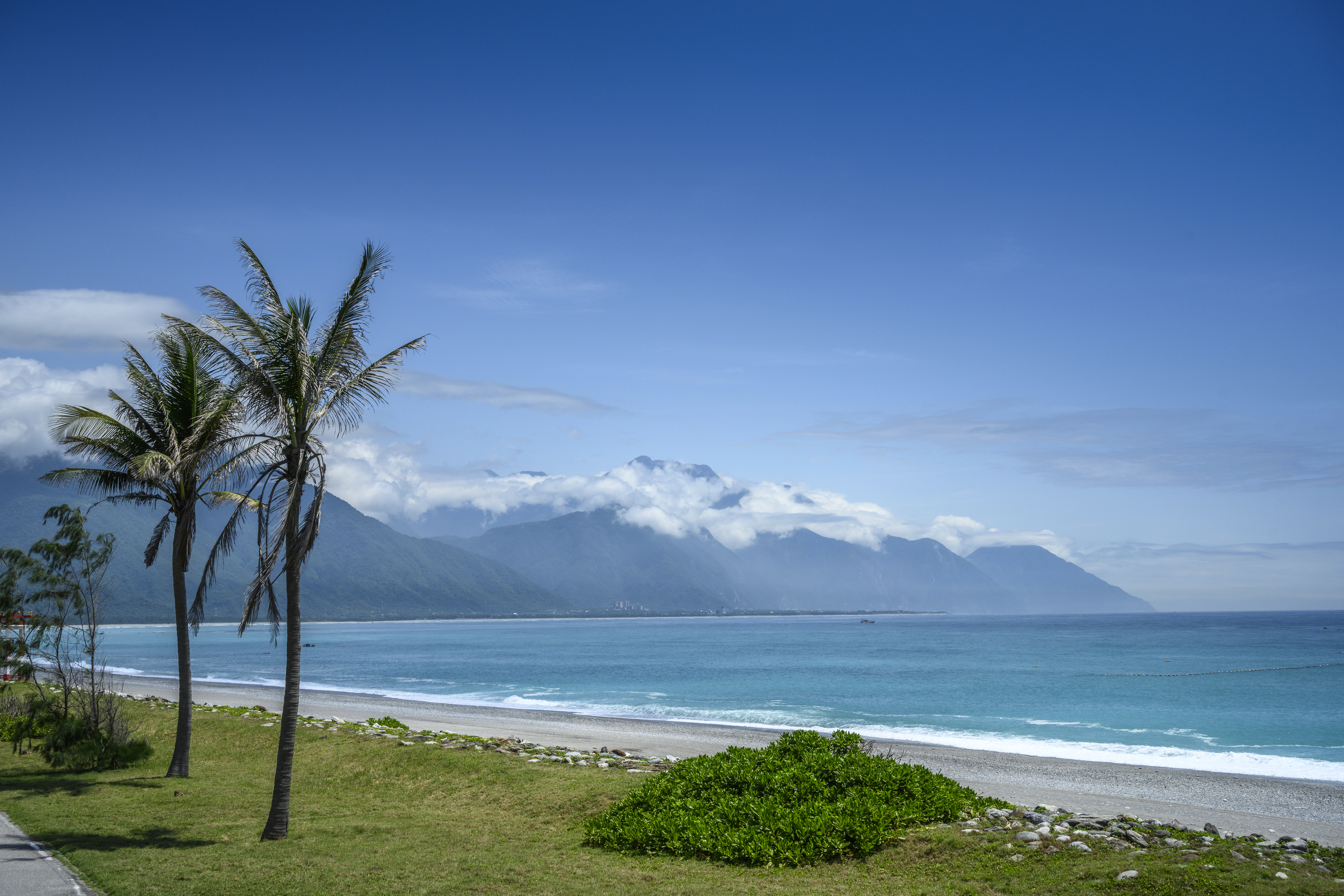
Qixingtan Beach, 2021. Photo: Artemas Liu, CC BY-SA 2.0 via Wikimedia.
After the earthquake, Teyra Yudaw also told The Reporter what he had observed among his people: “Our people feel that this space seems to be getting farther and farther away from us. In the past we lived here, and things were fine; the animals did not become fewer. The government says it wants to protect the mountains and forests, but from our people’s perspective, it has not truly protected them.”16 The Truku recovered their name only in 2004; in 2024, the national park collapsed. The 20 years from name rectification to losing access again to this landscape fold the timeline of a people’s relationship with a land.
Fenglin, Yuli, and Ruisui Beneath the Fu Family Dynasty
The final axis for looking at Hualien is local politics.
Hualien County’s “Fu family dynasty” is one of the longest continuously governing families in Taiwan’s local political history.25 Fu Kun-chi was elected legislator as a People First Party member in 2001, switched to the Kuomintang in 2008, and was elected legislator again. In 2009, after failing to receive the Kuomintang nomination, he ran independently for Hualien County magistrate without party affiliation and won, becoming Hualien County’s second non-Kuomintang magistrate. He was reelected in 2014. On September 12, 2018, in the Hogi stock case, an eight-month prison sentence was finalized, and he was removed from the magistrate’s office by law. In 2020, he was elected Hualien legislator as an independent.25
In the 2018 local elections, Fu Kun-chi’s wife, Hsu Chen-wei, was nominated by the Kuomintang and elected Hualien County magistrate with 72.4% of the vote, becoming the county’s first female magistrate. In 2022, she was reelected with 64.57% of the vote, setting a record for the highest vote share among county and city heads.25 The Reporter’s long-running series “The Two Faces of Fu Kun-chi: Looking Into the Hualien King Phenomenon” notes that the Fu family used “second reserve funds” to develop tourism night markets and deployed NT$800 million in donations from the 2018 Hualien earthquake to relieve industries, consolidating a “structure of complicity” with local industrial interests.26
But Hualien’s story has never been confined to Hualien City.
Fenglin Township sits in the middle of the East Rift Valley. It covers 121 square kilometers and has a population of about 12,500; Hakka people account for around 70%. Taiwan Panorama called it “one of the most ‘authentic’ Hakka towns in all Taiwan.”27 Fenglin has another, more unusual record: more than 100 school principals at various levels have come from there, the highest density in Taiwan, giving rise to the saying, “Fenglin produces principals; Meinong produces PhDs.” The Hakka culture of farming in fair weather, studying in rain, and valuing education, together with the Fenglin District Office chief’s residence from the Japanese period, now the Principal’s Dream Factory, as an education center, turned this small town into the hometown of principals.27 One of the former occupants of the Principal’s Dream Factory was Chang Chi-lang, a victim of the 228 Incident and the first principal of Hualien High School. Fenglin’s Hakka migration history also dates to the early Japanese period: large numbers of tenant farmers from Hsinchu Prefecture, where land was concentrated and incomes were low, migrated south to Hualien and Taitung; after the war, more Hakka people moved in.
Fenglin pastor Chen Minghui told Taiwan Panorama: “Don’t underestimate these elders riding electric scooters or bicycles. Ask any one of them casually, and they are all over 80 years old.”27 Fenglin resident Liu Qingsong added: “At its peak in the 1960s, Fenglin’s population once reached 30,000; now only 12,459 remain.”27 From 30,000 to 12,459: this is the epitome of population outflow from Hualien’s townships.
Yuli, Ruisui, and Zhuoxi in southern Hualien are home to Bunun people who moved down from Nantou in the 1930s. Xincheng Township and the Ruisui area are core Sakizaya residential areas. Xiulin and Wanrong townships sustain the Truku population. Beneath the Fu family dynasty’s vote totals are the 320,000 people formed by these six Indigenous peoples, Hakka villages, and descendants of Japanese-period immigrant villages. Their memories of “Hualien” have never been limited to the county government and Taroko.
The Gift Remains, the Open-Cut Tunnel Has Collapsed
Return to those 98 seconds at 7:58 a.m. on April 3, 2024.
Lin Maoyao said that after that day, when he went to Swallow Grotto, he kept trying to remember what it had originally looked like. “It felt especially bright; it turned out the entire open-cut tunnel had collapsed.”23 After the open-cut tunnel collapsed, light poured directly into the Liwu River valley, and he saw a Taroko Gorge he had never seen in his 20 years as an interpreter: the space that should originally have held cliffs pressing against the trail, the open-cut tunnel, and tourists had opened up. A landscape wrapped for decades in human engineering returned, in 98 seconds, to what it had looked like before the national park was established in 1986, perhaps even before the 1914 Truku Incident.
The Sakizaya only recovered their name in 2007; in 1986, Tzu Chi Hospital was built around the bishop wood tree where the lingchi execution had taken place. The Truku only recovered their name in 2004; in 2024, the national park’s iconic trails were all destroyed. The tobacco barns brought by Japanese settlers to Toyota Village in 1913, the perilous Suhua coastal road of 1932, the North-Link Railway’s reduction of 18 hours to 5 hours in 1980, and the full opening of the Suhua Improvement Project in 2020: every segment of history tried to pull Hualien closer to the outside world. But after those 98 seconds in 2024, the earth told everyone: what you thought was “near” was borrowed.
Teyra Yudaw said that “the name Taroko is the best gift our people have given Taiwan.”16 That gift remains. Even if the open-cut tunnel at Swallow Grotto has collapsed, Shakadang Trail has broken, and the Tunnel of Nine Turns must be repaired until 2031, the Truku remain, and so do their language, Gaya ancestral law, and facial-tattooing culture. The Sakizaya Fire God Festival will still be held this October in Hualien City’s Guofu community. The Bunun of Zhuoxi Township will still sing eight-part polyphony. The Hakka grandfathers and grandmothers of Fenglin will still ride electric scooters home from the fields.
Viewed from the Pacific, this thinnest five-kilometer strip of land between mountains and sea is still there. Southward from Qingshui Cliff, the Liwu River will keep cutting marble. Xiulin Township’s annual rainfall will still reach 4,000 millimeters. The Philippine Sea Plate will keep pushing north. No one knows when the next magnitude 7 earthquake will come, but it will. Hualien people were already learning to live with earthquakes 50 years ago: Yuli 7.3 in 1951, offshore 6.8 in 1986, Shoufeng 7.1 in 2024. Each one teaches the next generation how to press chairs under tables, where to put the emergency bag, and how to crawl out of shaking.
The next time you go to Hualien, do not go only to Taroko. Try driving to Xincheng Township at five in the morning and looking at the living bishop wood trees beside Tzu Chi Hospital. You will not know which tree is the one from 1878, but you will know the soil underneath still remembers. Or go to Hualien City’s Guofu community and ask which day the Fire God Festival is, then go see how Palamal places the battle of 1878 into today’s ritual. Or go to Darong Village in Fenglin and look at Chang Chi-lang’s bookshelf inside the Principal’s Dream Factory: the house left by a principal killed in 1947 is still teaching this town how to produce principals.
All of Hualien’s beautiful landscapes were bought with millions of years of the earth’s shaking. Every ethnic name was recovered through generations of living under concealed identities.
Taroko National Park may reopen seven years from now. But after 0403, those who return to Swallow Grotto will not see what people saw before April 2, 2024.
Further Reading
- Yilan County — A companion article in the 22 Counties and Cities series. The Kavalan of Kalyawan migrated south from Yilan’s Lanyang Plain to Hualien in the 1830s; the two articles extend each other.
- Keelung City — The first pilot article in the 22 Counties and Cities series; like Hualien, it is a northeastern coastal county or city “unseen by the capital.”
- Taroko National Park — Taiwan’s fourth national park, established in 1986; after the 0403 earthquake, recovery is estimated to take seven years.
- Taiwan’s Plate Movement and Earthquake Activity — The place of the 0403 earthquake in Taiwan’s seismic history: the East Rift Valley fault system in the collision zone between the Philippine Sea Plate and the Eurasian Plate.
- History and Name-Rectification Movements of Taiwan’s Indigenous Peoples — The trajectories of name rectification in Hualien among the Sakizaya, Truku, Seediq, and Kavalan.
- Cultural Map of Taiwan’s 16 Indigenous Peoples — The distribution in Hualien of the Amis, Truku, Sakizaya, Seediq, Bunun, and Kavalan.
- Japanese Colonial Period — The 1913 Toyota, Yoshino, and Hayashida immigrant villages; the 1914 Truku Incident; and Bunun group relocation in the 1930s.
- Lin Yi-hsiung — Tangwai movement figure from Wujie Township, Yilan, sharing with Hualien the same axis of Taiwan’s democratization in the 1980s.
Image Sources
This article uses six CC-licensed images from Wikimedia Commons. The hero image is Taiwan 2009 CingShui Cliffs on SuHua Highway FRD 6762 Pano Extracted by Fred Hsu, CC BY-SA 3.0, a 2009 panorama of Qingshui Cliff along the Suhua Highway.
Inline scene images, in order: Taiwan LiWu River by Vegafish, CC BY-SA 2.5, showing the Liwu River cutting through marble strata in Taroko Gorge; 20170924-火神祭開工祭祀 (19) by Tokoabibi, CC BY-SA 4.0, the 2017 Sakizaya Fire God Festival opening rite; Taiwan 2009 HuaLien City JingSi Hall FRD by Fred Hsu, CC BY-SA 3.0, Tzu Chi Jing Si Hall, Hualien City, 2009; Rescue workers near the semi-collapsed ten-story Uranus Building on Xuanyuan Road after the 2024 Hualien earthquake by Presidential Office Shufu Liu, CC BY 2.0, the Uranus Building rescue scene after the 0403 earthquake; Qixingtan Beach, Taiwan by Artemas Liu, CC BY-SA 2.0, Qixingtan Beach in 2021.
Video Materials
The Taroko National Park Headquarters’ 2025 documentary “Walking on the Road Home: Taroko” records conditions in the park after the 0403 earthquake and reflections by park interpreters. It can be found on the official Taroko National Park YouTube channel. Official video records of the Sakizaya Fire God Festival, Palamal, can be found by searching “Palamal nu Sakizaya” on the official Indigenous Peoples Cultural Foundation IPCF YouTube channel, where several videos also available on Wikimedia Commons can be found.
References
- Qixingtan — Wikipedia — The history of how, in 1936 during Japanese rule, the original north-south Qixingtan lake group east of the airport was filled in to build Hualien Harbor North Airfield, today’s Hualien Airport; how original residents were relocated to the Pacific coast and kept using the old place name; and how a “place name misplaced onto a tourist site” was formed.↩
- Truku people — Wikipedia — Complete ethnic information on migration from Nantou across the mountains to the Liwu River basin about 300 years ago; classification as “Atayal” during Japanese rule; Executive Yuan recognition as the 12th Indigenous people on January 14, 2004; Truku meaning “a platform on the mountainside” and “a place suitable for living”; main settlements in Xiulin Township, Wanrong Township, parts of Zhuoxi Township, and Qingfeng, Nanhua, and Fuxing villages in Ji’an Township; and traditions of facial tattooing and Gaya ancestral law.↩
- Kalyawan Incident — Wikipedia — Full event record of the Kavalan interception of Qing grain-transport documents on June 18, 1878; the June 19 joint siege of Quezilong Battery; the participation of Komod Pazik, chief of the Sakizaya Takubuwan community; the Qing fire attack on Takubuwan; the verbatim record that “after the Sakizaya surrendered, Qing troops bound Komod Pazik to a bishop wood tree near today’s Hualien Tzu Chi Hospital and executed him by lingchi”; and the verbatim record that “after Takubuwan was breached, the two peoples suffered near extermination. Survivors fled to the Rift Valley and the east coast, hiding among the Amis until name rectification succeeded in 2007.”↩
- Toyota Immigrant Village — Taiwan Panorama — History of Japanese-period immigrant villages: in 1913, the Governor-General’s Office recruited farmers from Hokkaido and Shikoku; Toyota Village received its first 179 households and 866 people in July 1913; grid streets; each household received a 441-ping house lot and courtyard plus 3 jia of farmland; Yoshino Village was built beside Hualien City; Hayashida Village, today’s Fenglin Township, had Taiwan’s highest density of tobacco barns; the three villages totaled 3,386 settlers; and postwar takeover by benshengren and Hakka transformation, including Lintianshan’s image as “Hualien’s Little Jiufen.”↩
- Hualien County — Wikipedia — Complete geographic data: area of 4,628.57 square kilometers, Taiwan’s largest county; 137.5 kilometers north to south; about 5 kilometers at the narrowest east-west point around Qingshui Cliff; 85% mountainous; only 15% plains and river terraces; three major terrain belts of Central Mountain Range, East Rift Valley, and Coastal Mountain Range; and a population of about 320,000 at the end of 2024.↩
- The Past and Present of Taroko Gorge — Taroko National Park Headquarters — Geological formation history: the Penglai Orogeny 6 million years ago; collision between the Philippine Sea Plate and the Eurasian Plate; the Liwu River cutting through marble; the verbatim passage “About 6 million years ago, the Philippine Sea Plate began colliding with the margin of the continental plate... the Liwu River appeared, and happened to flow across this thick marble layer. Like a sharp blade, the Liwu River’s water continually eroded downward. The wondrous Taroko Gorge slowly formed over millions of years through the two forces of plate uplift and river downcutting”; and marble dating back 250 million years.↩
- 1951 Hualien earthquake series — Wikipedia — Hualien earthquake-history timeline: the first East Rift Valley earthquake-series quake on October 22, 1951, ML 7.3, epicenter offshore southeast of Hualien City, 85 dead, 200 severely injured, more than 1,000 lightly injured; the second ML 7.3 quake on November 25 affecting the Yuli area; and the November 15, 1986 undersea ML 6.8 quake east of Hualien, with 15 dead, 62 injured, the Suhua Highway and Central Cross-Island Highway completely cut off, and the North-Link Railway’s tracks twisted.↩
- 2024 Hualien earthquake — Wikipedia — Full data: 7:58:09 a.m. on April 3, 2024; epicenter in Shoufeng Township, Hualien County, 23.88°N, 121.57°E; depth 19.7 kilometers; Central Weather Administration initial magnitude ML 7.2, revised on February 1, 2025 to ML 7.1; maximum intensity 6-upper in Heping Village, Xiulin Township, lasting about 98 seconds; 20 deaths, final count confirmed on April 25, 1,155 injured, 2 missing; deaths of worker Yu at kilometer 183.2 of the Central Cross-Island Highway, 17-year-old intern Huang at Silks Place Taroko, and female resident Kang in the Uranus Building; and Taiwan’s largest inland earthquake since the 1999 921 earthquake.↩
- Taiwan 2024 rainfall statistics — Central Weather Administration — Climate data on Hualien’s frequent eastern typhoon tracks, annual rainfall exceeding 4,000 millimeters in Xiulin and Wanrong townships, and Xiulin Township, Hualien, recording Taiwan’s highest number of rainy days in 2024, with 334 days, followed by Datong in Yilan with 320 and Wanrong in Hualien with 304, as well as the overlay of typhoons, southwesterly flows, and northeast monsoons.↩
- Hualien County Indigenous population statistics — Council of Indigenous Peoples — Official population statistics: 94,134 Indigenous people in Hualien County at the end of 2024, accounting for 29.8% of the county; Hualien’s share of Taiwan’s Indigenous population at 15.4%, the highest nationwide; and the distribution structure of six co-resident peoples.↩
- Sakizaya name rectification — Taiwan Panorama 2007 — Complete record of the name-rectification movement: Tiway Sayun, Chinese name Li Laiwang, launched name rectification beside the Meilun River in July 1990; the Palamal Fire God Festival was resumed in the Guofu community on July 1, 2006, after 128 years of suspension; the Executive Yuan, during the Chen Shui-bian administration’s second term, recognized the Sakizaya as the 13th Indigenous people on January 17, 2007; Council of Indigenous Peoples minister Walis Pelin’s verbatim statement that “Ethnic recognition mainly relies on the wishes of each people’s communities, as well as particularities of language, religion, culture, and so on. The Sakizaya were able to become Taiwan’s 13th Indigenous people not only because ethnic will was high, but also because the Sakizaya have a distinctive language and culture; only then could name rectification succeed”; and the verbatim statement that “In 1878, the ‘Kalyawan Incident’ occurred. The Sakizaya were defeated, causing community members to scatter and migrate; in addition, during the Japanese period, to escape forced labor and floods, they became even more displaced, and from then on concealed their identities beneath Amis communities.”↩
- Truku Incident — StoryStudio — Full event history: fifth Taiwan governor-general Sakuma Samata’s Five-Year Plan to Govern the Aborigines, 1910-1915; the 1896 Xincheng Incident in which Japanese soldiers sexually assaulted Truku women and the Truku launched a surprise attack killing 13 officers and soldiers; Sakuma appointing himself commander of the punitive expedition on May 14, 1914, and ordering the campaign on May 17; Japanese mobilization of 6,235 military and police plus 11,075 miscellaneous laborers, more than three times the Truku male fighting population of 3,000; the verbatim tactics of “traditional hunting methods, traps, falling rocks, adept use of strongholds, terrain, landforms, camouflage and concealment, night operations, ambushes, guerrilla warfare, surprise attacks, flanking maneuvers, and other tactics”; Holok-Naowi leading his people to submit on July 3, 1914; Japanese police casualties of 138 and military casualties of 226; and postwar group relocation policy.↩
- Bunun migration history — Wikipedia — Complete migration record: original homeland in Nantou County’s Zhuoshui River basin, Xinyi and Ren’ai townships; five major communities, Takituduh, Takibakha, Takbanuaz, Isbukun, and Takopulan; Japanese-period group relocation policy from 1904 onward; serial migrations to Hualien’s Yuli and Zhuoxi during the late 1930s, the first phase of the Kominka movement, 1936-1940; Takiivatan migration to Mayuan Village in Wanrong Township and Zhuoxi Township; Takbanuaz migration to Zhuoxi Township and Haiduan Township in Taitung; and Pasibutbut, an eight-part polyphonic millet-harvest prayer song, listed as a Hualien County cultural asset.↩
- History of the Tzu Chi Foundation — Tzu Chi Foundation — Complete founding history: in 1964 Dharma Master Cheng Yen, born Wang Jinyun in Qingshui, Taichung, in 1935, stayed with disciples at Puming Temple; on May 14, 1966, the 24th day of the third lunar month, the Buddhist Compassion Relief Tzu Chi Merit Association was founded in Hualien; in 1968, land was mortgaged to build the Tang-style main hall of the Jing Si Abode; in 1969, the Jing Si Abode was completed in Kangle Village, Xincheng Township; the bamboo bank years of 30 female believers saving 50 cents a day and the verbatim slogan “We save 50 cents every day! We have a relief association to help others!”; announcement of hospital construction on May 10, 1979; groundbreaking on February 5, 1983; opening of Hualien Tzu Chi Hospital on August 17, 1986; and upgrade to eastern Taiwan’s only medical center in 2002.↩
- Jing Si Abode — Official Jing Si Abode website — Official information on the abode’s core spirit of “No work, no meal,” monastics’ self-sufficiency through handmade foods such as Xiangji tofu and Jing Si noodles, the present site in Kangle Village, Xincheng Township, and the Tang-style main hall.↩
- Truku autonomy dreams and 0403 — The Reporter — In-depth reporting on Truku autonomy after the 0403 earthquake, including three first-hand quotations from Teyra Yudaw, secretary-general of the Truku Name Rectification Association and chair of the Truku Hunters Association: “The name ‘Taroko’ is the best gift our people have given Taiwan”; “Our people feel that this space seems to be getting farther and farther away from us. In the past we lived here, and things were fine; the animals did not become fewer. The government says it wants to protect the mountains and forests, but from our people’s perspective, it has not truly protected them”; and “At present there is no cultural tourism; it is relatively purely natural landscape. But for a place to develop tourism, it cannot rely only on natural resources. It should also take humanistic resources into account, only then can it have richness and vitality.”↩
- Seediq and Amis — Council of Indigenous Peoples — Official data: the Seediq were recognized as the 14th Indigenous people on April 23, 2008, sharing origins with the Truku but remaining in Nantou; the Amis are Taiwan’s largest Indigenous people, with 220,000 people; five subgroups, Nanshi, Xiuguluan, Coastal, Falangaw, and Hengchun; Nanshi Amis in Xincheng, Hualien City, Ji’an, Shoufeng, and Fenglin; Coastal Amis in Fengbin and around the Xiuguluan River mouth; and the harvest festival, Ilisin, mainly held each August as Taiwan’s largest Indigenous festival.↩
- Kavalan name rectification — Council of Indigenous Peoples — Name-rectification and migration history: the Kavalan were recognized as the 11th Indigenous people on December 25, 2002, the first officially recognized Pingpu people; they migrated south from Yilan’s Lanyang Plain to Hualien in the 1830s and 1840s; Kalyawan, today’s Jiali Village in Xincheng Township, was a large community of 2,000 people; after the 1878 Kalyawan Incident, people dispersed to Hualien’s east coast, including Xinshe and Lide, and Taitung, including Zhangyuan and Dafengfeng; and by 1896 only 2,903 Kavalan remained on the Lanyang Plain.↩
- Suhua Historic Trail and opening the mountains and pacifying the aborigines — Wikipedia — Formation history of the Qing-period eastern development trunk route: in 1875, the first year of the Guangxu reign, Shen Baozhen’s policy of opening the mountains and pacifying the aborigines; Luo Dachun supervising construction of the “northern route” from Su’ao to Qilai, today’s Hualien; and the Suhua Historic Trail as the main route for eastern development during Qing rule.↩
- Asia Cement Xincheng Mountain mining controversy — Our Island, PTS — Complete controversy record: Hualien’s 300-billion-metric-ton marble deposits; origins of white, gray, and black marble and serpentinite; expansion from the 1960s of mines in Heping, Hezhong, Heren, the Taroko entrance, and Sanzhan; stone-processing industry annual output value of NT$21 billion to NT$31 billion; upstream and downstream workforce of 15,000, one-tenth of the county labor force; Asia Cement’s 1975 entry into Xincheng Mountain to mine limestone for cement raw material; the mining area’s location at the Taroko National Park entrance on the south bank of the Liwu River; the “Oppose Asia Cement, Return Our Land Self-Help Association” led by Truku woman Tien Chun-chou; the 2017 mining-right extension for 20 years to 2037; the Supreme Administrative Court’s dismissal of Asia Cement’s appeal on September 16, 2021, revoking the extension but allowing mining to continue under the Mining Act; and the controversial February 12, 2022 consultation and consent vote in the Bsngan community.↩
- North-Link Railway — Wikipedia — Complete railway history: construction began on December 25, 1973, as part of the Ten Major Construction Projects; the Hualien Harbor to Xincheng section opened on July 26, 1975; the Heping to Hualien New Station section was completed in December 1978; the full line opened on February 1, 1980, shortening Keelung-to-Hualien travel from 18 hours to about 5; investment of NT$7.3 billion and six years of construction; establishment of the Heping cement plant; and changes to eastern tourism and education connections.↩
- Suhua Improvement Project and Suhua Safety Improvement Project — Wikipedia — Complete road-evolution history: the Suhua Improvement Project totals 38.8 kilometers, including 8 tunnels totaling 24.6 kilometers, 13 bridges totaling 8.6 kilometers, and 5.6 kilometers of surface roads; the Su’ao-to-Dong’ao section opened on February 5, 2018; the Nan’ao-to-Heping and Hezhong-to-Daqingshui sections opened on January 6, 2020, completing the full line; replacement of the “nine bends and eighteen turns” section; the 119-kilometer 1932 Suhua coastal road known as “the world’s most dangerous road”; two-way traffic in 1990; and the 29.9-kilometer Suhua Safety Improvement Project, Dong’ao to Nan’ao 9.3 kilometers, Heping to Hezhong 5.5 kilometers, and Heren to Chongde 15.1 kilometers, expected to begin construction in 2025 and finish in 2032.↩
- Taroko’s heaviest damage in 38 years since opening — Central News Agency, 2025 — Recovery progress record: Shakadang, Swallow Grotto, and Tunnel of Nine Turns trails suffered the worst damage; Taroko National Park Headquarters deputy director Lin Zhongshan’s verbatim statement “Developing alternative attractions and promoting in-depth ecotourism is also necessary”; senior interpreter Lin Maoyao’s verbatim statement “Swallow Grotto shocked me the most. After the earthquake, when I came to Swallow Grotto, I kept trying to remember what it had originally looked like. It felt especially bright; it turned out the entire open-cut tunnel had collapsed”; estimated whole-park recovery time of “about seven years,” with Shakadang and Swallow Grotto reconstruction estimated for completion in 2031; park headquarters’ admission that “opening the entire park in seven years is probably impossible”; partial area opening starting July 1, 2025; and phased openings of trails along the Suhua Highway from April 2025.↩
- Hualien tourism impact 2024 — Tourism Administration statistics — Tourism impact figures: before the earthquake, Taroko received about 4 million visitors annually, up to 6.6 million at peak; in 2024 Taroko had only a little more than 210,000 visitors, 3.2% of its peak; Hualien County as a whole had 6.7 million tourist visits in 2024 compared with 14 million in 2023, a 54.29% decline and the largest in the past decade; and 22 of 135 hotels exited or suspended operations.↩
- Fu Kun-chi and Hsu Chen-wei — Wikipedia — Political history of the Fu family dynasty: Fu Kun-chi was elected legislator as a People First Party member in 2001, switched to the Kuomintang in 2008 and was elected again, won the Hualien County magistracy as an independent in 2009, becoming the county’s second non-Kuomintang magistrate, was reelected in 2014, was removed from office after an eight-month prison sentence in the Hogi stock case was finalized on September 12, 2018, and was elected independent legislator in 2020; Hsu Chen-wei was nominated by the Kuomintang and elected Hualien’s first female magistrate in 2018 with 72.4% of the vote, then reelected in 2022 with 64.57%, setting a record for the highest vote share among county and city heads.↩
- The Two Faces of Fu Kun-chi: Looking Into the Hualien King Phenomenon — The Reporter — Long-term investigative reporting series on the Fu family’s political economy: use of second reserve funds to develop tourism night markets, deployment of NT$800 million in donations from the 2018 Hualien earthquake to relieve industries, and a “structure of complicity” with local industrial interests.↩
- Fenglin Hakka town — Taiwan Panorama — Fenglin is located at the center of the East Rift Valley plain, with an area of 121 square kilometers and a population of about 12,500, around 70% Hakka; the verbatim description “one of the most ‘authentic’ Hakka towns in all Taiwan”; more than 100 principals from the town, the highest density in Taiwan; “Fenglin produces principals; Meinong produces PhDs”; the Principal’s Dream Factory, formerly the Fenglin District Office chief’s residence during Japanese rule, as an education center; the residence of Chang Chi-lang, first principal of Hualien High School and a victim of the 228 Incident; pastor Chen Minghui’s verbatim statement “Don’t underestimate these elders riding electric scooters or bicycles. Ask any one of them casually, and they are all over 80 years old”; Liu Qingsong’s verbatim statement “At its peak in the 1960s, Fenglin’s population once reached 30,000; now only 12,459 remain”; and the Fenglin Hakka history of tenant farmers from Hsinchu Prefecture migrating south during the early Japanese period.↩