30-second overview: Gueishan Island is a 2.841-square-kilometer volcanic island off the coast of Yilan, about 10 kilometers from Wushi Harbor in Toucheng. It is 3.1 kilometers wide east to west and 1.6 kilometers long north to south. It is the foremost of the Eight Views of Lanyang, "Sunrise over Gueishan," and the landmark Yilan people see the moment they emerge from the Snow Mountain Tunnel and think, "almost home." But this "symbol of home" was obtained through a relocation without compensation: at its historical peak, the island had more than 100 households and over 700 residents. They began moving out in stages in 1974, and in 1977 the Ministry of National Defense sealed off the island. Residents moved into a resettlement community in Daxi, Toucheng. Each household received a NT$150,000 Bank of Taiwan loan to be repaid over 16 years, and they had to pay for the land themselves. From 1977 to 2000, Yilan people on shore could not even set foot on the island; the Gueishan Islanders who had actually lived there saw their houses demolished and their temple moved away. Their home was still there, but they could no longer return. This article wants to say: the island remains, but the people who remember the island are passing away.
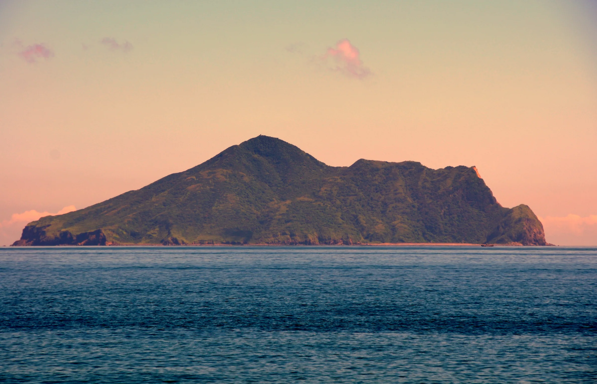
Seen from the sea, Gueishan Island's turtle-shaped outline is unmistakable: the turtle head is on the right, the shell rises in the middle, and the tail drags out a sandbar to the left. (阿爾特斯 / Wikimedia Commons, CC BY-SA 3.0)
The Dreams Grandmother Huang Chen-yu Has Every Night
If you meet an elderly woman surnamed Huang in Toucheng and ask her what place she knows best, she will not point to Toucheng Old Street, nor to Wushi Harbor. She will point toward the turtle-shaped island out at sea.
Huang Chen-yu was 33 when she moved from Gueishan Island to Toucheng, and 68 when she was interviewed by Taiwan Panorama, more than thirty years later.1 She remembered why they had no choice but to leave: "It wasn't that we were willing to leave, but at that time there was no water and no electricity, and strange incidents kept happening on the island where babies died right after birth. For the future of the children and grandchildren, we had to move here."1 She agreed to leave because conditions on the island truly could not keep the next generation. But agreeing to leave and letting go are two different things.
What she said next is the spine of this whole article: "Thinking about all these years living on Taiwan, every night when I dream, what I still dream of is everything about life on Gueishan Island."1 Her body had slept in Toucheng for thirty years; her dreams had never come ashore.
Turn the lens back to the shore. For Yilan people who never lived on Gueishan Island, the island exists in another way. It is the most fixed point on the horizon seen from the Lanyang Plain, a weather marker for fishers, and the thing people returning home see when the car exits the Snow Mountain Tunnel and they glance left toward the sea: when they see it, they know they are almost home. (When traveling south back to Yilan, the island is in the sea on the left; only when heading north out of Yilan does it shift to the right.) The poet Lin Huan-chang, from Jiaoxi, wrote of Gueishan Island: "You are the island I saw at first glance when I was born; an island that moves."2
Gueishan Island is therefore two kinds of "home" at once. For Yilan people on shore, it is the direction of home, visible every day, yet for the 22 years from 1977 to 2000 they could not set foot on it. For the Gueishan Islanders who actually lived there, it is a home they cannot return to: they can go there, but can never live there again. Visible but unreachable; reachable but unlivable. The same island, two opposite forms of homesickness.
A Living Island, but No Living Residents
To understand why Gueishan Island is so hard to release, one first has to know that the island itself is still breathing.
It is one of Taiwan's few confirmed active volcanoes. The criteria are an eruption within the last 10,000 years and continuing geothermal activity today; Gueishan Island satisfies both. Using thermoluminescence dating, the Department of Geosciences at National Taiwan University tested sedimentary xenoliths embedded in the island's volcanic rock and dated them to roughly 7,000 years ago. It inferred that the island had at least four volcanic events in the past 7,000 years, with the most recent possibly occurring at the turtle head.3 Its earlier origins go farther back: using potassium-argon dating, the Geological Survey placed the island's formation in several submarine volcanic eruptions between about 200,000 and 20,000 years ago.4
What gives the three words "active volcano" real weight is the detection work by Lin Cheng-horng's team at Academia Sinica. Using S waves, they detected a magma reservoir beneath Gueishan Island at a depth of about 13 to 23 kilometers, around 30 kilometers long and 10 kilometers wide, roughly 1.5 times larger than the Tatun Volcano Group in northern Taiwan.5 Chiang Hsieh-tang of National Ilan University conducted microseismic monitoring and recorded more than 10,500 earthquakes of magnitude 1 or above from 2007 to 2009, averaging about 17 per day.6 Underground, the island has never been quiet.
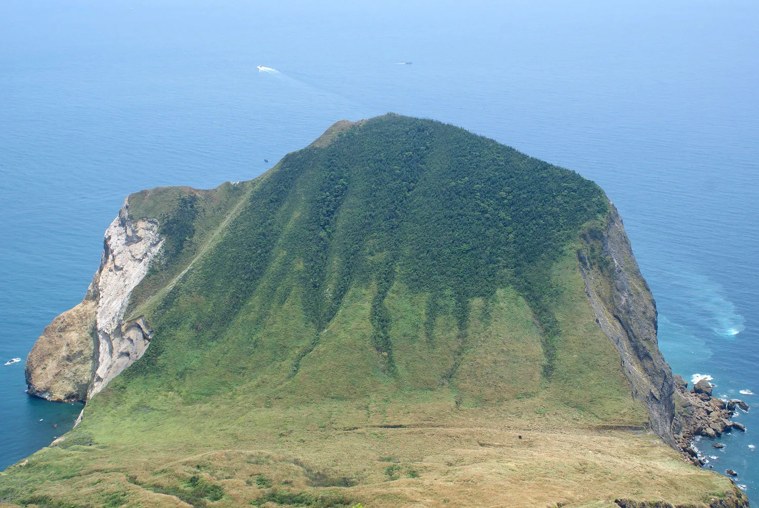
The andesite cliffs of the turtle head drop straight into the sea; beneath them lie the submarine hot springs of the Milk Sea. (Peellden / Wikimedia Commons, CC BY-SA 3.0)
📝 Curator's note: Media outlets love to use "active volcano" as a sensational headline, as if Gueishan Island were about to erupt at any moment. But when one opens up the geological timescale, something more thought-provoking appears: geologically, this island is alive. The geological clock is still running, the magma reservoir is still below, and sulfur vents are still smoking. The human residents, however, were completely evacuated in the 1970s. A living island has not a single living resident. Weigh the word "living" on both sides, the volcano and the inhabitants, and Gueishan Island's absurdity and sorrow lie in that gap.
The island's most famous spectacle is called the "Milk Sea." In front of the turtle head is a submarine hot spring field of about half a square kilometer, with more than 30 vents at depths of 5 to 30 meters that turn the surface water milky white.7 Online explanations often say the white color is hot spring water or calcium carbonate; both claims can be ruled out. English-language academic research shows that the whiteness of the Milk Sea comes from elemental sulfur precipitates, microbubbles formed by sulfur and carbon dioxide, and aggregations of sulfur bacteria, which together whiten the surface water.8
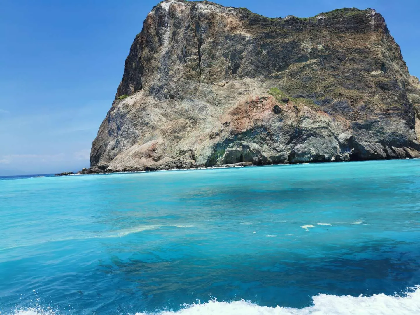
The Milk Sea in front of the turtle head: submarine sulfur hot springs whiten the surface water, clearly separating it from the surrounding blue sea. (Ping an Chang / Wikimedia Commons, CC BY-SA 4.0)
The numbers tell how extreme that hot spring field is. At the Yellow Spring vents, temperatures reach 92 to 116 degrees Celsius, with pH around 4.5; at the White Spring vents, temperatures are 48 to 62 degrees Celsius, with pH around 5.9. At the center of the hot spring field, pH falls as low as 1.52, making it one of the world's most extreme submarine hydrothermal environments.9
The creature best able to tell the story of this hot spring field is a crab called the turtle crab. Its carapace resembles a turtle shell, and Taiwanese scholars described it as a new species in 2000 under the scientific name Xenograpsus testudinatus.10 It lives only in the hot spring zone at depths of 5 to 30 meters, feeding on plankton killed by sulfur fumes and falling from the upper layers, along with symbiotic bacteria. Its density can reach 364 individuals per square meter.10 In an environment exceeding 100 degrees Celsius with pH 1.5, surrounded by things cooked to death by hot springs, it thrives. One common claim needs caution: the turtle crab is often called endemic to Taiwan, but it is also found in waters south of Kagoshima, Japan, so it cannot be considered unique to Gueishan Island.10
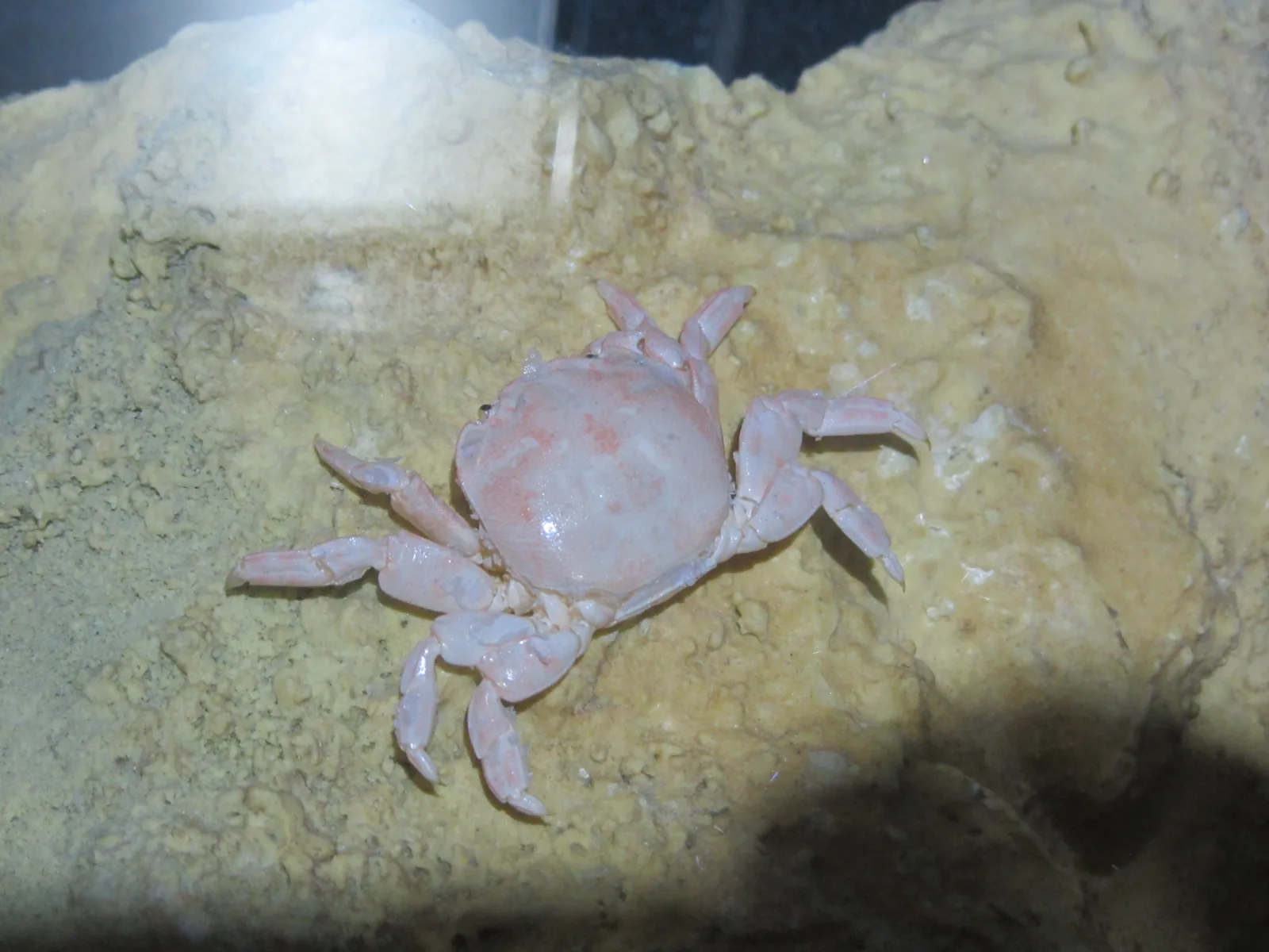
The turtle crab, described as a new species by Taiwanese scholars in 2000, has a turtle-shell-like carapace and lives by eating plankton killed by sulfur fumes and falling from above. (SSR2000 / Wikimedia Commons, CC BY-SA 3.0)
Incidentally, the island is still moving. GPS observations show that Gueishan Island is slowly moving east-southeast by about 3.3 centimeters per year, with cumulative movement of 10.2 centimeters from 2007 to 2010.11 Lin Huan-chang's line, "an island that moves," began as a poet's romantic imagination; geology supplied a literal footnote.
Life Once on the Island: A Fishing Village Without Water or Electricity, and a Temple That Changed Its Main Deity Three Times
Beyond geology, people really lived on this island, and for a long time.
Where they lived was decided by the island's shape. Most of Gueishan Island is surrounded by steep cliffs. Only at the western "turtle tail" is there a flat, wind-sheltered sandbar beneath the protection of the peaks: about thirty-some hectares, slightly higher than the surrounding coast, and the only habitable part of the island.12 The settlement lined up three rows of houses along a single road, less than 200 meters from end to end and walkable in ten minutes; during Japanese rule, many houses were built from stacked pebbles.12 When the military later moved in, its barracks were also placed on the same ground, while the temple, the cold spring, and the later Guanyin statue all stood around Guiwei Lake. Village, military camp, and faith: several generations were all layered on this sandbar. Whoever came could only live here.
During the Daoguang reign of the Qing dynasty, a person named Huang Wu A-kan brought a statue of Nezha from Xinghua, Fujian, and first enshrined it at home.13 In the fourth year of Xianfeng (1854), islanders built a temple; in the eleventh year of Guangxu (1885), they pooled funds to acquire deity statues and formally established the temple, with Third Prince Nezha as the main deity.13 In Showa 16 (1941), islanders found an unmanned empty boat at sea carrying a statue of Mazu, the sea goddess, and welcomed Mazu into the temple.13 In 1967, the temple was rebuilt and named Gonglan Temple, meaning "to guard Lanyang," and the main deity became Mazu.13
The succession of main deities at this temple is almost a miniature of Gueishan Island's fate. Between 1989 and 1990, Guanyin was installed; in January 2000, the military handed the island over to the Coast Guard Administration, and the temple was renamed Putuoyan, enshrining Guanyin.14 Nezha, Mazu, Guanyin: the temple on a small island changed its main deity three times. The gods came and went, and understood more clearly than people what this island had experienced. The old temple's address still records one location: No. 282, Gueishan Village, Toucheng Township.13
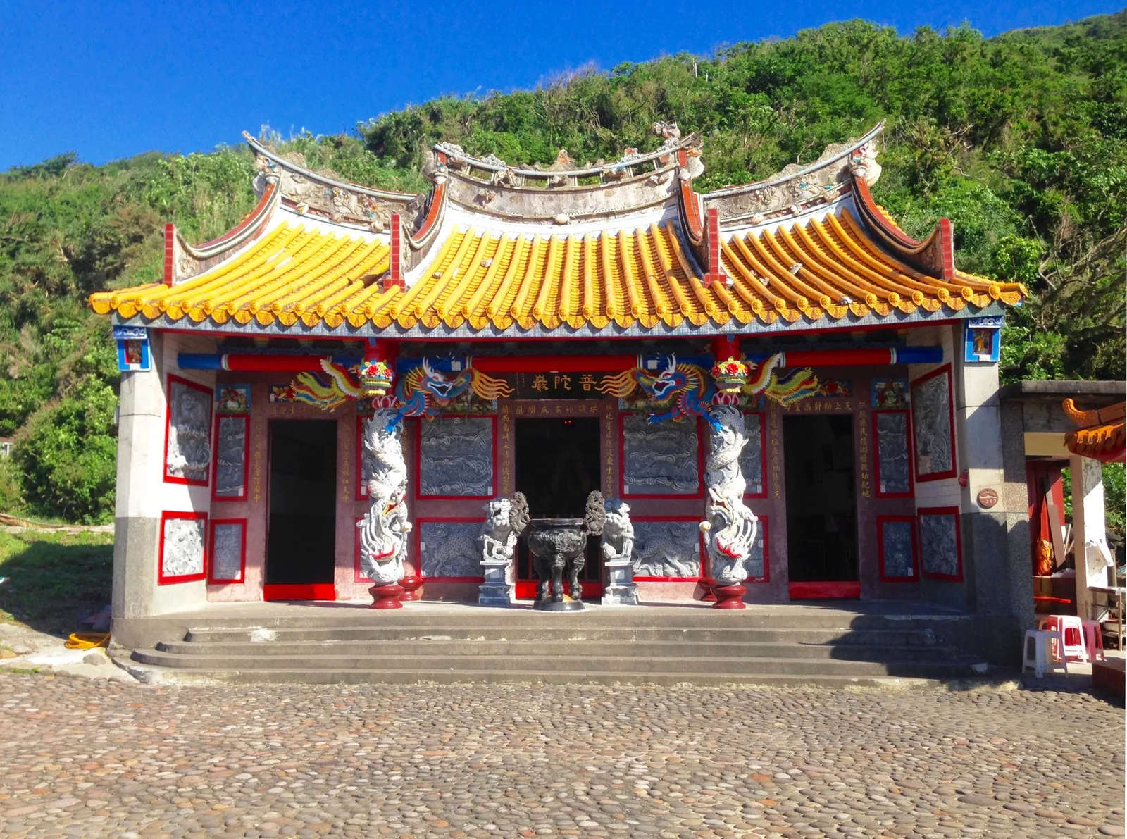
Putuoyan was formerly Gonglan Temple. Its main deity changed from Nezha to Mazu and then to Guanyin, almost a miniature of Gueishan Island's fate. (Outlookxp / Wikimedia Commons, CC BY-SA 4.0)
Life on the island was difficult. There was no running water, no electricity, and children could study only through elementary school at most. Its most distinctive tradition was called "doing the mid-sixth month." Writer Wu Min-hsien's 1975 article recorded the origin of this custom: Gueishan Island fishers would be hired in Nanfang'ao for deep-sea voyages, leaving around Qingming and returning only after about 100 days.15 This meant they missed Mazu's birthday on the 23rd day of the third lunar month, so islanders simply folded Mazu's birthday into the Third Prince's birthday on the 15th day of the sixth lunar month.15 On that day, every household reunited as if celebrating the New Year, and they would invite Taiwanese opera troupes to perform for several days in a row.15 A compromise forced by maritime labor rhythms became the island's liveliest festival.
But this way of life was draining away from the roots. By the year Wu Min-hsien wrote the article, the island's population had already fallen sharply from its peak. The number he recorded was: "At its greatest number, the residents once reached more than 100 households and over 700 people. In recent years they have successively moved away, leaving only more than 30 households, all living by fishing."16 From more than 700 people to just over 30 households, the people of this island were leaving household by household.
Relocation: A Farewell Without Compensation
This is the center of the article. Why Gueishan Islanders left, how they left, what they received afterward, and what they did not receive: the answers to these questions determine how one understands this island. The timeline must return to 1971, when Yilan County Magistrate Lee Feng-ming went to the island for a village residents' meeting, proposed relocation, and promised residents that they could "return home at any time."17 For islanders, there were already fewer and fewer reasons to stay: repeated typhoons, food shortages, lack of medical care, only elementary education, and young women unwilling to marry into an island with no water or electricity, creating crises in marriage and population.17 In 1974 (ROC year 63), the county government formally proposed relocation, and some people began moving out voluntarily.17
Daxi Gueishan Village chief Chien Ying-chun left at that time. His reason was simple: his children's education. He later recalled that period to Taiwan Panorama: "Since ROC year 63, I left the place where I grew up for the children's education. I never thought that the next year Gueishan Island would be designated a military restricted area. When I set foot on the island again, it was already 20 years later..."18 When he left, he could not have known that it would take twenty years before he could step on that land again.
In July 1975, Wu Min-hsien wrote the essay later cited over and over, "Gueishan Island: An Island Soon to Be Forgotten," serialized over two days in the China Times Human Realm supplement.16 In the article, he almost shouted on behalf of hesitant islanders: "Relocate! Relocate! What are we still guarding?" "Relocate! Relocate! Our generation has already fallen behind, but the children still have time!"16 The title of that article read like a prophecy: an island soon to be forgotten.
By 1977 (ROC year 66), the matter had reached its conclusion. The Taiwan Provincial Department of Civil Affairs subsidized loans to build 106 public housing units in Daxi, Toucheng, and residents moved in collectively. This resettlement community was called Renze Community. That same year, the Ministry of National Defense officially sealed the island and designated Gueishan Island a military restricted area.17 The following year, in 1978, Gueishan Village was merged into Daxi Village, and the village name disappeared from the administrative map. It would not be restored until July 1, 2001.19
The key controversy lies in the two words "compensation." Many introductions lightly say the government "properly resettled" residents, but once the details are laid out, that claim does not hold. What residents received was a loan, not compensation: NT$150,000 per household, to be repaid to the Bank of Taiwan over 16 years.20 The land for Renze New Village was purchased jointly by the residents themselves.20 In other words, they lost their ancestral home and received a debt to be repaid, along with land they had to buy at their own expense.
The deeper problem was the original land on the island. Chiang Chin-ming, chair of the Gueishan Island Community Development Association, once said something heavy: "No matter how foolish people were back then, they could not possibly have sold it to you [the government] for NT$1 per ping."21 He was referring to the contract by which the land was acquired by agreement at "one yuan per ping." Lin Tsai-hsing, a National Cheng Kung University professor and Gueishan Islander, recalled it even more directly: "Later, the army tore down all our houses, and everything at home was gone. People even mocked themselves by saying we were 'Gueishan fools' for not pursuing the matter."21 "Gueishan fools" was a name they gave themselves, a bitter self-mockery.
Hsu Shih-jung, a professor in National Chengchi University's Department of Land Economics, explained the nature of the matter most clearly. He pointed out that the land on Gueishan Island had already been under state custody since ROC year 43, so by ROC year 63 there was no need to expropriate it again. He offered this judgment: "What Gueishan Island encountered was not land expropriation, but land confiscation."21 Expropriation requires compensation; confiscation does not. One word's difference means two entirely different treatments. Later, the Control Yuan intervened to investigate and determined that the expropriation process back then "indeed had flaws," recommending that the government address the matter.20 Only decades late did an official body acknowledge that something had been wrong in this relocation.
Place these statements side by side, and the truth of the relocation emerges. People on shore said the government had resettled residents well; people who had lived on the island said their houses were demolished, their belongings disappeared, and their land was taken at NT$1 per ping. One relocation, two memories. What spread widely was the warm version of "having no choice but to move for the next generation"; what was forgotten were the embarrassing details of loans, self-funded land purchases, and land confiscation.
Twenty-Two Years as a Restricted Zone: Gun Barrels Pointed at Yilan
After the island was closed in 1977, Gueishan Island changed from a fishing village into a fortress.
It was taken over by soldiers of the army's Lanyang Division, with about 100 troops stationed there at first.22 The reason for the closure must be stated clearly, because a mistaken version circulates saying it was to guard against a People's Liberation Army invasion after the 1979 severing of U.S.-ROC diplomatic relations. The chronology does not fit: the diplomatic break occurred in 1979, two years after the island was closed in 1977.22 The real background was Cold War-era eastern coastal defense. Gueishan Island controlled a key position off the Lanyang Plain and was a piece on Taiwan's eastern coastal defense line.
The scale of military works on the island was substantial. According to official records from Public Television Service, the military tunnels are 800 meters long in total. The main tunnel is 3.5 meters high and 3 meters wide, and the secondary tunnels are 1.9 by 1.9 meters.23 The firepower configuration included three 90 mm antiaircraft guns, four 40 mm antiaircraft guns, and one machine-gun position.23 At the end of the main tunnel there remains an abandoned M1A1 90 mm gun on an M3 mount, a coastal defense gun delivered through U.S. aid in 1953 and replaced only in 1979 by Swiss 35 mm rapid-fire guns.23 One point requires correction: some sources write this gun as "M190 mm," but that is a layout misreading. The correct designation is M1A1 90 mm gun.23 The tunnels were not excavated at the same time the island was closed; they were dug successively from 1979 to 1983, and about 200 meters are now open to visitors.23 In summer, the tunnels are cool and pleasant, and the garrison nicknamed them "Gueishan-brand air conditioning."23
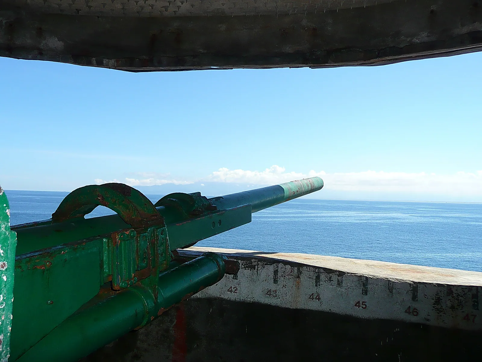
Artillery fort remains in the tunnel. During the 22 years of closure, the island's guns pointed toward Taiwan proper, at Yilan. (lienyuan lee / Wikimedia Commons, CC BY 3.0)
What is most striking is the direction of the gun barrels. These artillery pieces faced Yilan on Taiwan proper. This was a crossfire design: if enemy forces landed, firepower from the island could form a pincer with defenses on Taiwan proper.24 In other words, during those 22 years, Yilan people on shore looked at Gueishan Island every day, and the gun barrels on the island also pointed at them every day.
For Yilan people, those 22 years were the most concrete period of "visible but unreachable." Gueishan Island was right there, clearly visible every day from the Lanyang Plain, yet it was a restricted zone that no one could even approach. The number of troops fell as the times loosened: from more than 100 at first, to about 40 before opening, to only about eight Coast Guard personnel stationed there today.24 The force guarding the island shrank from a company to a squad.
The restricted zone also had gray areas. On the eastern cliff of Gueishan Island is a sea cave eroded into a semicircle by seawater; seen from the sea, it resembles a pair of eyeglasses, so it is called Eyeglasses Cave. It is one of the Eight Views of Gueishan, and there are stalactites inside.25 According to the Northeast Coast Administration, because the cave's terrain is complex and the location secluded, in the ROC 70s fishers from both sides of the Taiwan Strait would take advantage of dark and windy nights to conduct smuggling transactions in the surrounding waters. The area was therefore jokingly called the "Gueishan Night Market."25 An island was sealed off by the military, forbidden to approach, yet the sea at its feet became a black market open at night. In November 2021, a large rockfall above Eyeglasses Cave collapsed, almost completely blocking the entrance. A whale-watching boat interpreter said it was the first time he had seen such a large volume of fallen rock. With Yilan's heavy rain and the island's easily weathered volcaniclastics, even this island's scenic wonders cannot be preserved.26
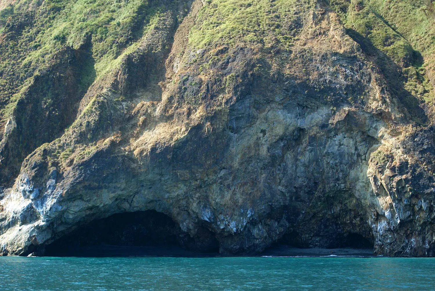
Eyeglasses Cave, one of the Eight Views of Gueishan. In the ROC 70s, this area was once the "Gueishan Night Market" where fishers from both sides of the Taiwan Strait smuggled goods at night; a 2021 rockfall nearly blocked the cave entrance. (Peellden / Wikimedia Commons, CC BY-SA 3.0)
Returning to the Island: From Military Restricted Zone to Marine Ecological Park
After martial law was lifted in 1987, calls to open Gueishan Island gradually rose. On December 22, 1999, the Executive Yuan announced a partial opening, and on August 1, 2000, the island officially opened for tourism. Gueishan Island was incorporated into the Northeast and Yilan Coast National Scenic Area and positioned as a "marine ecological park."27 After 22 years of closure, the island finally opened its doors to people again.
But opening the door did not mean throwing it wide open. Landing on the island was subject to total capacity controls from the start, with quotas gradually loosened: 250 people per day in 2000, 350 in 2002, 400 in 2005, and a current daily limit of 1,800, divided into four time slots of 450 people each.27 Wednesdays are limited to 500 people and only for academic purposes.27 The island's highest point, Hill 401, has had a separate restriction since 2018: only 100 people may summit each day, and only in the morning.27 The opening season runs from March 1 to November 30 each year. To land on the island, visitors must apply online to the Northeast Coast Administration 20 days in advance and pay a NT$100 fee.27
資料來源:Northeast and Yilan Coast National Scenic Area Administration
Incidentally, the name "Hill 401" needs clarification. It is often mistaken as an elevation of 401 meters, or as the military's No. 401 hill. In fact, Gueishan Island's highest turtle-shell peak was originally 398 meters above sea level; adding the later two-story viewing platform brings it to 401.28 A number remembered by tourists is actually the sum of original terrain and a human-made structure.
The most popular activity after reopening has been whale watching. Cetaceans are abundant in the waters around Gueishan Island because the Kuroshio flows along the continental shelf edge and forms upwelling, bringing nutrients from the deep.29 Another common claim also needs correction: many promotional texts say "the Kuroshio and Oyashio meet" here, but the Oyashio does not reach these waters at all; as for "Qingchao," that is a term invented by operators.29 The Lanyang Museum lists five main cetaceans: spinner dolphins, bottlenose dolphins, pygmy killer whales, false killer whales, and common dolphins.29 As for operators' frequent claims of "17 species of cetaceans" and "sighting rates above 90 percent," the former lacks a primary academic list as support and is a marketing aggregation, while the latter is also an operator claim and should be read with caution.29 One more fact is worth remembering: the true birthplace of commercial whale watching in Taiwan was Shitiping Harbor in Hualien, where the Haijing made its first voyage in July 1997. Wushi Harbor began the same year under encouragement from the county government, but scaled up alongside the opening of Gueishan Island in 2000.30
The ecology on land is just as rich. Along the trail around Guiwei Lake is what officials identify as "Taiwan's only natural primary stand of fan palms."31 The island is also home to the Formosan flying fox: an endemic Taiwanese subspecies, an endangered protected species, and Taiwan's largest bat, with a wingspan that can reach one meter.32 Dr. Chen Hsiang-fan found a small group of about 20 on the island around 2009; observations in 2019 still recorded roughly 20 individual sightings, and the group had already reproduced for several generations.32 This bat formerly lived mainly on Green Island, where development greatly reduced its numbers, making Gueishan Island an important refuge. During the 22 years when humans could not enter, the closure unexpectedly preserved habitat for these organisms. An island cleared for military purposes ultimately nurtured an ecological paradise.
Guiwei Lake itself has a story. It was originally a freshwater lake. Residents once channeled seawater into it in hopes of building a fishing harbor, but the embankments were repeatedly destroyed by typhoons, leaving the lake now half fresh and half saline.31 The sandbar by the lake, which shifts north and south with the monsoon, is the "spirit turtle wagging its tail" among the Eight Views of Gueishan.
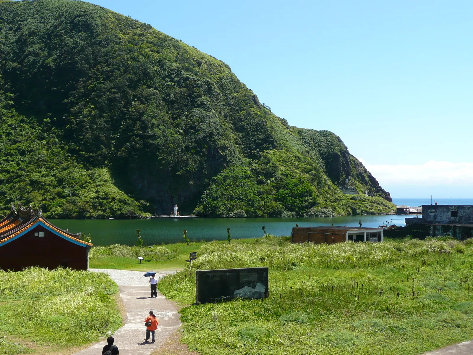
Guiwei Lake is now half fresh and half saline. Along the trail around the lake is Taiwan's only natural primary stand of fan palms. (lienyuan lee / Wikimedia Commons, CC BY 3.0)
A lighthouse also stands at the turtle tail, but its origins are, like the island itself, a blank that cannot be traced. Among the 36 lighthouses officially managed by the Maritime and Port Bureau of the Ministry of Transportation and Communications, there is no Gueishan Island lighthouse; nor can it be found on maps of lighthouse distribution in Taiwan during Japanese rule.33 It is certainly there and can be photographed from the sea, yet it is like an unregistered lighthouse: when it was built and who manages it now cannot be found in public records. Most likely, it was a navigational facility built by the military during the 22 years of military control.33 Even a lighthouse on the island carries an origin from the restricted-zone years that no one can explain clearly.
The Geography of Homesickness: Legends, the County Emblem, and a 9.8-Meter Mazu
Gueishan Island is not only a geographic island. It long ago grew into Yilan people's collective imagination and became a symbol.
The oldest saying is "the turtle and snake guard the seaport." This is a Han Chinese feng shui view, recorded about 200 years ago in the Gazetteer of Kavalan Subprefecture.34 According to legend, Xuantian Shangdi was originally a butcher. When he cultivated the Way and ascended to heaven, he cut open his belly, and the organs he threw out turned into the divine generals Turtle and Snake. The turtle is Gueishan Island, and the snake is the coastal sand ridge from Toucheng to Wuwei Harbor. Together, they guard Lanyang's seaport.34 An island and a sand ridge were imagined as two heavenly gatekeepers.
Another more widely circulated story is "Princess Kavalan and General Turtle." Here an important point must be made clear: this story is not an indigenous Kavalan myth, but a literary creation by writer Wu Min-hsien in 1975.35 The Lanyang Museum's cultural award selection committee states in black and white that this is a "mythic story created" by Wu Min-hsien.35 The story says that Princess Kavalan, daughter of the Dragon King of the East Sea, fell in love with General Turtle. They fled the Dragon Palace and had a child. The Dragon King, enraged, sent a flood and transformed the father and son into two islands, while the princess became the Lanyang Plain.35 This creation later spread widely and was adapted into picture books, children's theater, and Chinese music compositions. Many people came to think it was an Indigenous legend passed down for a thousand years. That a story written by a writer in 1975 became, half a century later, an "ancient legend" in collective memory is itself worth thinking about.
Gueishan Island's status as a symbol of Lanyang is backed by official documents. The Eight Views of Lanyang were selected in the fifth year of Daoguang (1825) by Wu Zhufang, Kavalan subprefect; "Sunrise over Gueishan" ranked first among the old eight views.36 Wu Zhufang also wrote a poem for it: "At dawn the peak rises high across half the sky; encircled blue waves gleam like a mirror. A lone sail passes below the mountain; from afar one sees the red sun born from jade waves."36 This island has served as Yilan's face for two hundred years.
Even the county emblem is connected to it, and it hides an interesting detail. Seen from the Lanyang Plain, the turtle's head actually faces east and appears to face right; but on the Yilan County emblem, the turtle's head faces left.37 It was designed when Liu Shou-cheng was county magistrate, based on the impression of a northbound traveler entering Shicheng and seeing Gueishan Island for the first time, its head facing left.37 The designer chose the first impression of a person returning home from afar, setting geographic correctness aside. The county emblem itself is a decision about coming home.
Yilan people's feelings toward the island also entered weather proverbs. "When Gueishan wears a hat, great waters surge"; "When Gueishan covers its head, heavy rain can arrive at any time." Looking to see whether clouds cover Gueishan Island's head tells one whether to bring an umbrella.2 If the turtle-tail sandbar breaks in two, elders say a typhoon is coming.2 One island is at once landmark, legend, and weather station.
For the actual islanders, however, a symbol can never replace the home they cannot return to. In January 2016, islanders who had relocated to Toucheng's Renze Community, now the restored Gueishan Village, erected a 9.8-meter granite Mazu statue in the community at a cost of NT$13 million.38 The Mazu of the island's Gonglan Temple, the one welcomed in Showa 16 from an unmanned empty boat, had her spirit brought back to the islanders' side. Since they could not return to the temple on the island, they built a home anew on shore for the goddess, and for themselves.
Conclusion: The Island Remains; Those Who Remember It Soon Will Not
Return to the elderly woman surnamed Huang.
Huang Chen-yu once said something that reaches the bottom of the relationship between the island and its people: "Gueishan people cannot do without this island!"1 It sounds as though she were saying Gueishan Island cannot do without people. In fact, the reverse is true: Gueishan people cannot do without the island. The island does not need people and still lives on. The magma reservoir still moves beneath it, sulfur vents still smoke, turtle crabs still eat plankton cooked to death beside hot springs above 100 degrees Celsius, flying foxes still reproduce, and the entire island still moves 3.3 centimeters to the southeast each year. It is people who cannot leave the island, not the island that cannot live without people.
That Yilan County article wrote of Gueishan Island as the "only coordinate that will not be changed" on the Lanyang Plain. That is the shore's perspective, geography's eternity. From the islanders' perspective, what is eternal is another, more painful thing: the island will always be there, will always be treated by Yilan people as the direction of home, will always be the "almost home" uttered at the Snow Mountain Tunnel exit. But the people who truly lived there, who knew how many days of Taiwanese opera were needed for the mid-sixth-month festival and remembered the year Gonglan Temple changed its main deity, are aging one by one.
What the second generation remembers is mostly already the island in grandmother's words, not the island they walked on with their own feet. Those waterless and electricity-less nights, the fear of infants dying, the waiting for fishing boats to return after 100 days at sea, the land taken at NT$1 per ping: as Huang Chen-yu's generation passes away, these details are moving from firsthand memory into secondhand retelling, and then into blanks no one remembers.
The title Wu Min-hsien gave this island in 1975 was "An Island Soon to Be Forgotten." Half a century later, he was half right and half wrong. Gueishan Island has not been forgotten: it became the foremost of the Eight Views of Lanyang, the county emblem, a scenic destination thousands of visitors enter lotteries to land on every day, and that 9.8-meter Mazu statue. What is remembered is the scenery and legend. What has been forgotten are the people who lived there.
Next time you drive back to Yilan, emerge from the Snow Mountain Tunnel, and look left to see that turtle-shaped island in the sea, remember this: beneath the coordinate that says "almost home," it is still the former home of more than 700 people, the place Grandmother Huang Chen-yu still dreams of every night. The island will always be there, but the people who remember this will not.
Further Reading
- Yilan County — The county to which Gueishan Island belongs; the story of how the Lanyang Plain made choices at two critical moments in history, treating Gueishan Island as an "unchanging coordinate"
- Taiwan's Coastal Landforms and Marine Landscapes — The place of Gueishan Island's volcanic island, submarine hot springs, and upwelling within Taiwan's marine landscapes
- Cetaceans of Taiwan — Cetacean ecology brought by the Kuroshio, and the context in which Taiwan's whale-watching industry began at Shitiping Harbor in Hualien
- Outlying Islands and Maritime Culture — Shared themes in Taiwan's outlying island settlements, fishing village beliefs, and histories of village relocation
- Green Island Prison — Another history of an outlying island militarized and then opened, moving from restricted zone to public site
Image Sources
All images in this article are from Wikimedia Commons — Category:Gueishan Island. Authors and licenses have been verified file by file, and EXIF/GPS data have been removed before conversion to WebP:
- Whole-island hero: 阿爾特斯 / Wikimedia Commons — CC BY-SA 3.0
- Milk Sea: Ping an Chang / Wikimedia Commons — CC BY-SA 4.0
- Turtle head: Peellden / Wikimedia Commons — CC BY-SA 3.0
- Putuoyan: Outlookxp / Wikimedia Commons — CC BY-SA 4.0
- Military artillery fort: lienyuan lee / Wikimedia Commons — CC BY 3.0
- Guiwei Lake: lienyuan lee / Wikimedia Commons — CC BY 3.0
- Turtle crab (specimen): SSR2000 / Wikimedia Commons — CC BY-SA 3.0
- Eyeglasses Cave (sea cave): Peellden / Wikimedia Commons — CC BY-SA 3.0
References
- Homesickness of Gueishan Grandmother — Taiwan Panorama — Oral interview with Gueishan Islander Huang Chen-yu (moved to Toucheng at 33, interviewed at 68), including verbatim homesick remarks: "It wasn't that we were willing to leave, but at that time there was no water and no electricity, and strange incidents kept happening on the island where babies died right after birth"; "every night when I dream, what I still dream of is everything about life on Gueishan Island"; and "Gueishan people cannot do without this island!"↩
- An Island That Moves — Straits Exchange Foundation — The original line by Jiaoxi poet Lin Huan-chang, "You are the island I saw at first glance when I was born; an island that moves," as well as Yilan weather proverbs including "When Gueishan wears a hat, great waters surge," "When Gueishan covers its head, heavy rain can arrive at any time," and the belief that a split turtle tail foretells a typhoon.↩
- Is Gueishan Island an Active Volcano? — Union Catalog of Digital Archives and Learning — Academic determination by the Department of Geosciences at National Taiwan University: thermoluminescence dating of sedimentary xenoliths in volcanic rock to about 7,000 years ago, at least four volcanic events in the past 7,000 years, and the most recent possibly at the turtle head.↩
- Gueishan Island: A Mysterious Active Volcano — Taiwan Geoscience Portal, Geological Survey — Primary geological data from the Geological Survey and Mining Management Agency, Ministry of Economic Affairs, on Gueishan Island's andesitic lava flows and volcaniclastic rocks, and potassium-argon dating indicating formation by several submarine volcanic eruptions from about 200,000 to 20,000 years ago.↩
- Magma reservoir beneath Kueishantao volcano — PMC6219605 — Academic paper by Lin Cheng-horng's Academia Sinica team using S waves to detect a magma reservoir beneath Gueishan Island at 13-23 kilometers depth, about 30 kilometers long by 10 kilometers wide, roughly 1.5 times larger than the Tatun Volcano Group (Academia Sinica, 2018).↩
- Gueishan Island Microseismic Monitoring — Environmental Information Center — Evidence of active volcanism from National Ilan University scholar Chiang Hsieh-tang's 2007-2009 microseismic monitoring, which recorded about 10,562 microearthquakes of magnitude >=1.0, averaging about 17 per day.↩
- Who Poured Milk into the Sea? — PanSci — Popular science explanation of the Milk Sea: a submarine hot spring field of about 0.5 square kilometers in front of the turtle head, with more than 30 vents at depths of 5-30 meters turning the surface water milky white.↩
- Geochemistry of the milk-coloured sea — PMC4744018 — Primary English-language academic study showing that the milky white color of Gueishan Island's Milk Sea comes from elemental sulfur precipitation, microbubbles formed by sulfur and carbon dioxide, and aggregations of sulfur bacteria (Epsilon/Gammaproteobacteria), ruling out the calcium carbonate explanation.↩
- Hydrothermal vent pH and temperature — PMC6894864 — Academic measurements of Gueishan Island's submarine hot springs: Yellow Spring 92-116°C / pH about 4.5, White Spring 48-62°C / pH about 5.9, and hot spring center pH as low as 1.52, among the world's most extreme submarine hydrothermal environments.↩
- Turtle Crab — The News Lens — Record of the turtle crab (Xenograpsus testudinatus): described as a new species by Taiwanese scholars in 2000, carapace resembling a turtle shell, living only in the 5-30 meter hot spring zone, feeding on plankton killed by sulfur fumes and falling from above as well as symbiotic bacteria, with density about 364 individuals per square meter, and also distributed in waters south of Kagoshima, Japan (not endemic to Taiwan).↩
- Gueishan Island Moves Every Year — Environmental Information Center — GPS observations showing Gueishan Island slowly moving east-southeast by about 3.3 centimeters per year, with cumulative movement of 10.2 centimeters from 2007 to 2010.↩
- Gueishan Island Settlement and Guiwei Sandbar — Lanyang Museum Newsletter Issue 162 — Settlement geography of Gueishan Island: the village was located on the northern sand spit at Guiwei on the western end, north of Guiwei Lake; this wind-sheltered flat land of about thirty-some hectares was the island's only habitable area. The settlement lined three rows of houses along one road, less than 200 meters long, with pebble houses from the Japanese period.↩
- Putuoyan, Gueishan Island — Wikipedia — Religious history of deity succession at Gonglan Temple: Huang Wu A-kan bringing Nezha from Xinghua, Fujian, during the Daoguang reign and enshrining him at home; temple built in Xianfeng 4 (1854); formal temple built in Guangxu 11 (1885) for Third Prince Nezha; Mazu from an unmanned empty boat welcomed in Showa 16 (1941); 1967 reconstruction and naming as "Gonglan Temple"; and old-site address "No. 282, Gueishan Village, Toucheng Township."↩
- Gueishan Island — Wikipedia — Temple history noting Guanyin installation at Gonglan Temple in 1989-1990 and renaming to "Putuoyan" after the military handed the island to the Coast Guard Administration in January 2000 (lead-level source, figures cross-checked elsewhere).↩
- Gueishan Island: An Island Soon to Be Forgotten (Doing the Mid-Sixth Month) — Wu Min-hsien — Wu Min-hsien's 1975 essay recording the "doing the mid-sixth month" custom: Gueishan Island fishers hired out from Nanfang'ao for distant-water fishing, leaving around Qingming and returning after about 100 days; because they could not return for Mazu's birthday on the 23rd day of the third lunar month, they combined it with the Third Prince's birthday on the 15th day of the sixth lunar month, with household reunions and Taiwanese opera troupes performing for several days.↩
- Gueishan Island: An Island Soon to Be Forgotten — Wu Min-hsien — Wu Min-hsien's essay serialized July 26-27, 1975, in the China Times Human Realm supplement, including verbatim lines: "At its greatest number, the residents once reached more than 100 households and over 700 people. In recent years they have successively moved away, leaving only more than 30 households, all living by fishing"; "Relocate! Relocate! What are we still guarding?"; and "Relocate! Relocate! Our generation has already fallen behind, but the children still have time!"↩
- From Fishing Village to Military Restricted Area — PeoPo Citizen Journalism — Timeline of Gueishan Island relocation: in 1971 (ROC year 60), County Magistrate Lee Feng-ming held a village residents' meeting proposing relocation and promising residents they could "return home at any time"; in 1974 (ROC year 63), the county government formally proposed relocation and some moved out voluntarily due to typhoons, food shortages, lack of medical care, only elementary education, and the loss of women; in 1977 (ROC year 66), the Provincial Department of Civil Affairs subsidized loans to build 106 public housing units and residents collectively moved into Renze Community in Daxi, Toucheng, while the Ministry of National Defense sealed the island as a military restricted area.↩
- Homesickness of Gueishan Grandmother (Chien Ying-chun oral account) — Taiwan Panorama — Verbatim statement by Daxi Gueishan Village chief Chien Ying-chun: "Since ROC year 63, I left the place where I grew up for the children's education. I never thought that the next year Gueishan Island would be designated a military restricted area. When I set foot on the island again, it was already 20 years later..."↩
- Restoration of Gueishan Village — Lanyang Museum — Administrative history showing Gueishan Village merged into Daxi Village in 1978, causing the village name to disappear, and restored on July 1, 2001.↩
- No Compensation for Relocation! The Government Owes Gueishan Islanders Justice — Watch Media — Investigative report on Gueishan Island relocation compensation controversy: 106 households received NT$150,000 each as Bank of Taiwan loans to be repaid over 16 years, not compensation; Renze New Village land was purchased jointly by residents; Control Yuan investigation found the expropriation process "indeed had flaws" and recommended government action.↩
- Gueishan Sunrise Again Civic Forum — Village Taipei — Forum record including National Cheng Kung University professor and Gueishan Islander Lin Tsai-hsing saying, "Later, the army tore down all our houses, and everything at home was gone. People even mocked themselves by saying we were 'Gueishan fools' for not pursuing the matter"; Gueishan Island Community Development Association chair Chiang Chin-ming saying, "No matter how foolish people were back then, they could not possibly have sold it to you [the government] for NT$1 per ping"; and National Chengchi University land economics professor Hsu Shih-jung saying, "What Gueishan Island encountered was not land expropriation, but land confiscation."↩
- Background to Gueishan Island Closure — UDN Time — Military history record of the Ministry of National Defense closing the island in 1977, the army's Lanyang Division taking over with about 100 troops, and the real closure background being Cold War eastern coastal defense because the island controlled a key position off the Lanyang Plain. The claim that it guarded against the 1979 U.S.-ROC diplomatic break is chronologically wrong, as that break came two years after the closure.↩
- Gueishan Island Tunnel Opens for the First Time — Public Television Service News — Official tunnel specifications: total length 800 meters, main tunnel 3.5 meters high and 3 meters wide, secondary tunnels 1.9 x 1.9 meters, three 90 mm antiaircraft guns, four 40 mm antiaircraft guns, one machine-gun position, abandoned M1A1 90 mm gun on M3 mount at the end of the main tunnel (U.S. aid in 1953, replaced by Swiss 35 mm rapid-fire guns in 1979), tunnels excavated 1979-1983 rather than at the time of island closure, about 200 meters open, and cool summer conditions nicknamed "Gueishan-brand air conditioning."↩
- Gueishan Island Military Tunnel and Crossfire Network — Hiking Biji — Record of Gueishan Island gun barrels facing Yilan on Taiwan proper to form a crossfire network, allowing island and Taiwan-proper defenses to attack enemy landings from both sides, as well as troop reductions from more than 100 initially (army Lanyang Division), to about 40 before opening, to about eight Coast Guard personnel today.↩
- Gueishan Island "Gueishan Night Market" Smuggling at Eyeglasses Cave — City Learning / Northeast Coast Administration — Verbatim Northeast Coast Administration account: "Because 'Eyeglasses Cave Stalactites' has complex terrain and a secluded location, in the ROC 70s fishers from both sides of the Taiwan Strait would also take advantage of dark and windy nights to conduct smuggling transactions in the surrounding waters at night, leading the area around the cave to be nicknamed the 'Gueishan Night Market.'" Eyeglasses Cave is a semicircular sea cave in the cliff, shaped like eyeglasses, and one of the Eight Views of Gueishan.↩
- Gueishan Island Eyeglasses Cave Collapse, Rockfall Blocks Entrance — ETtoday — Report on large rockfall above Eyeglasses Cave in November 2021, almost completely blocking the entrance; a whale-watching boat interpreter said it was the first time he had seen such a large rockfall. The report notes Yilan's heavy rainfall and the easy weathering of volcaniclastics (there had also been a collapse in March 2021).↩
- Twenty Years of Gueishan Island Capacity Controls — Environmental Information Center — History of capacity controls: Executive Yuan partial opening on December 22, 1999; official tourism opening on August 1, 2000; landing quotas rising from 250/day (2000) to 350 (2002) to 400 (2005) to 1,800/day today (four time slots of 450, Wednesday 500 for academic use only); Hill 401 limited to 100/day after 2018 and mornings only; opening season March 1-November 30; online application 20 days in advance and NT$100 fee.↩
- Gueishan Island Hill 401 Elevation — National Academy for Educational Research / Lanyang Museum — Topographic correction that Gueishan Island's highest turtle-shell peak was originally 398 meters above sea level; "Hill 401" refers to 398 meters plus a 3-meter two-story viewing platform, not military Hill No. 401 and not an original elevation of 401 meters.↩
- Gueishan Island Whale and Dolphin Watching — Northeast and Yilan Coast National Scenic Area — Whale-watching information: the Kuroshio forms upwelling over the continental shelf edge, not a "meeting of the Kuroshio and Oyashio," and "Qingchao" is an operator-invented term; the Lanyang Museum lists five main cetaceans (spinner dolphin, bottlenose dolphin, pygmy killer whale, false killer whale, common dolphin); operator claims of "17 cetacean species" and sighting rates "above 90 percent" lack primary academic support.↩
- History of Whale Watching in Taiwan — Ministry of Agriculture — Primary record that Taiwan's commercial whale watching originated at Shitiping Harbor in Hualien, with the Haijing first sailing in July 1997; Wushi Harbor began in 1997 with county government encouragement, and scaled up alongside the opening of Gueishan Island in 2000.↩
- Gueishan Island Ecotourism and Fan Palm Stand — Northeast and Yilan Coast National Scenic Area — Official ecological landscape information: along the Guiwei Lake trail is "Taiwan's only natural primary fan palm stand"; Guiwei Lake was originally a freshwater lake, residents channeled seawater to build a fishing harbor, embankments were repeatedly destroyed by typhoons, and it is now half fresh and half saline; the turtle-tail sandbar shifts north and south with the monsoon ("spirit turtle wagging its tail").↩
- Observation of Formosan Flying Fox on Gueishan Island — Newtalk — Record of the Formosan flying fox, an endemic Taiwanese subspecies, endangered protected species, and Taiwan's largest bat with a one-meter wingspan, discovered on Gueishan Island by Dr. Chen Hsiang-fan around 2009 as a small group of about 20. Observations in 2019 still recorded about 20 individual sightings and multiple generations of reproduction; the species formerly lived mainly on Green Island but declined sharply due to development.↩
- Gueishan Island Lighthouse — Wikimedia Commons (photo) / Maritime and Port Bureau lighthouse list (negative comparison) — Photo of the Guiwei lighthouse (lienyuan lee, 2009, Wikimedia category Lighthouses in Taiwan). The lighthouse is not in the Maritime and Port Bureau's official list of 36 managed lighthouses, nor in Academia Sinica's map of lighthouse distribution during Japanese rule, suggesting it was a navigational facility established by the military or Coast Guard during the postwar military-control period; no construction date or management unit can be found.↩
- The Turtle and Snake Guard the Seaport — Yilan View — Cultural history record of the Han Chinese feng shui legend "the turtle and snake guard the seaport," recorded in the approximately 200-year-old Gazetteer of Kavalan Subprefecture: Xuantian Shangdi, originally a butcher, ascended to heaven after cultivating the Way, cut open his belly, and threw out organs that became the divine generals Turtle and Snake; the turtle is Gueishan Island and the snake is the coastal sand ridge from Toucheng to Wuwei Harbor, together guarding Lanyang's seaport.↩
- Lanyang Museum Issue 135: Wu Min-hsien Cultural Award — The Lanyang Museum selection committee states plainly that "Princess Kavalan and General Turtle" is a "mythic story created" by Wu Min-hsien in 1975, not an indigenous Kavalan myth: Princess Kavalan, daughter of the Dragon King of the East Sea, and General Turtle fled the Dragon Palace and had a child; the Dragon King sent a flood, transformed father and son into two islands, and the princess into the Lanyang Plain. The story later spread widely and was adapted into picture books, children's theater, and Chinese music compositions.↩
- Sunrise over Gueishan Photography — Kamalan News — Record that the Eight Views of Lanyang were selected in the fifth year of Daoguang (1825) by Wu Zhufang, Kavalan subprefect; "Sunrise over Gueishan" ranked first among the old eight views, with Wu Zhufang's original poem: "曉峰高出半天橫,環抱滄波似鏡明。一葉孤帆山下過,遙看紅日碧濤生."↩
- Direction of the Turtle Head and the Yilan County Emblem — Liberty Times — Explanation from the county government's Civil Affairs Department: seen from the plain, the turtle head faces right because it actually faces east, but on the Yilan County emblem it faces left. The emblem was designed during Liu Shou-cheng's county magistracy and used the impression of a northbound traveler entering Shicheng and first seeing the turtle head facing left.↩
- Gueishan Islanders Erect 9.8-Meter Mazu Statue — Taiwan Cultural Memory Bank — Curatorial record of Gueishan Islanders relocated to Toucheng's Renze Community (restored Gueishan Village) erecting a new 9.8-meter granite Mazu statue in January 2016 at a cost of NT$13 million, bringing the Mazu faith of the island's Gonglan Temple back to their side.↩