
30-Second Overview: On April 17, 1923, Crown Prince Hirohito (裕仁) rode a carriage from Taipei Station along a 15-meter-wide road to the Taiwanese Shrine in Yuan Shan1. The Japanese named it "Imperial Envoy Street" (敕使街道); construction expansion began on March 30, 19372, and on the morning of March 28, 1941, a completion ceremony was held at the Taiwanese Shrine. The road was 40 meters wide, a five-lane avenue, featuring camphor trees in the median, maple trees inside the sidewalk, mercury streetlights, and underground wiring, with an estimated construction cost exceeding 1.62 million Japanese yen2. On October 25, 1945, at 10:00 AM, Ando Rikichi (安藤利吉) surrendered to Chen Yi (陳儀) at the Taipei Public Hall (now Zhongshan Hall)3, and Imperial Envoy Street was renamed "Zhongshan North Road" in commemoration of the Founding Father Sun Yat-sen. In 1951, following the Korean War, the U.S. Military Advisory Group (MAAG) occupied the area4, and the section of Zhongshan North Road became a "U.S. Concession Area," with Qingguang Market being a hub for P.X. imports5. On September 29, 1972, the day the Republic of China severed diplomatic relations with Japan, Japanese companies did not withdraw; on April 28, 1979, the last U.S. Defense Command commander, Major General Linder (林德), left Taiwan6. The former USTDC Yuan Shan headquarters site is now the Taipei Municipal Museum of Art6. In the 1980s, Japanese businesses instead moved in en masse, with over 400 Japanese-style bars and izakayas operating simultaneously in the alleyways7. Today, walking into San Tiao Tong (三條通) at nine o'clock in the evening, the lanterns of the izakayas are lit, and laughter mixing Japanese and Tâi-gí (Taiwanese Hokkien) is heard—a 5-kilometer long road, successively layered by three foreign empires. This article aims to show that Zhongshan North Road, as lived by Taipei residents, is not merely a "Founding Father Memorial Road," but a material landscape left behind after an island was taken over sequentially by three foreign empires.
San Tiao Tong at Nine PM
If you ask a 50-year-old Taipei resident what the most charming time of Zhongshan North Road is, they will not tell you about the red-tiled roof of the Grand Hotel Yuan Shan. They will say it is the moment you walk into San Tiao Tong at nine o'clock in the evening.
From Exit 4 of Zhongshan Metro Station, walking north for 50 meters and turning right onto Lane 53 of Zhongshan North Road Section 1, you enter the area of San Tiao Tong. The alley is 4 meters wide, flanked by old buildings three to five stories high, with signs on the first floor displaying Japanese Katakana and Kanji side-by-side: "Toruchu" (鳥忠), "Jolly Pasta," "Ryukyu Izakaya" (龍居酒屋), and "Yakitori Miyachika" (焼鳥みやちか). Before 5:30 PM, it is as quiet as Banqiao Alley, but after seven o'clock, one by one signs light up, and at nine o'clock, the curtain of a second izakaya opens, releasing laughter mixing Japanese and Tâi-gí.
Qi Tiao Tong (七條通) is the most famous alley for San Tiao Tong culture—Lane 121 of Zhongshan North Road Section 1, adjacent to Lane 119 of Linssen North Road8. The set of Huadeng Chushuang (華燈初上), which premiered on Netflix in 2021, was filmed in this alley; the entrance of the "Light" HIKARI hotel in the drama was shot at Sugar Bar in Qi Tiao Tong9. Lane 133 of Linssen North Road was the location where Lin Xinru and Yang Youning met for the first time.
However, the scope of San Tiao Tong culture is broader—Yi Tiao Tong (一條通) is Citizen Avenue; Er Tiao Tong (二條通) is Lane 33 of Zhongshan North Road Section 1; San to Jiu Tiao Tong (三到九條通) are neatly arranged between Lanes 33 and 135 of Zhongshan North Road Section 1, and Lanes 67 and 145 of Linssen North Road. Shi Tiao Tong (十條通) is Lane 159 of Linssen North Road8. The ten alleys run parallel to the north, designed like a Kyoto chessboard pattern, with East-West streets called "Tong" (通) and North-South streets called "Jin" (筋)10.
This grid structure was not born as a bar street. In 1922, when the Japanese mapped this area into the high-end residential district of "Taisho Town," they built exclusive mansions for Japanese officials and Westernized mixed residences—it was the safest and most respectable residential area during the Japanese rule in Taipei10. A century later, the residents changed within the same grid, but the alleys did not change—the material skeleton of Taisho Town is the material foundation of the San Tiao Tong bar street.
📝 Curator's Note: The common narrative describes San Tiao Tong as "a bar opened when the Japanese came to Taiwan," which omits a crucial timeline. In 1922, when the Japanese planned this high-end residential area, there were no bars here. After the Japanese withdrawal in 1945, the ROC government took over the Japanese dormitories and converted them into civil servant residences; it was still a residential area then. Bars emerged in these alleyways after the U.S. military arrived during the Korean War in 1951 (not Japanese izakayas, but American-style bars for American soldiers). After the Sino-Japanese diplomatic break in 1972 and the U.S. withdrawal in 1979, the "Japanese-style bars" of the 1980s were actually a second wave of Japanese businesses—office workers, not colonial officials. The same grid, the same orientation, but separated by the American military for 35 years. What we see at nine o'clock tonight is the result of a three-stage relay: Japanese high-end residences $\rightarrow$ Post-war U.S. Military Bars $\rightarrow$ 1980s Japanese Businesses.
Three Renamings for One Road
To understand Zhongshan North Road, one must first know its names.
During the Qing dynasty, this area was outside the Taipei city limits. Within the moat of the Taipei Prefecture City walls, completed in 1884, which covered 1.4 square kilometers, there were rice paddies, cemeteries, and scattered settlements east of the East Gate (Jingfu Gate). The southern end of today's Zhongshan North Road, near the Executive Yuan, was called "Kashan Town" at the time—a name given by the Japanese during the town renaming in 1922 to commemorate Kashan Chikichi (樺山資紀), the first Governor-General of Taiwan11.
Starting in 1898, the Japanese began developing the land north of Kashan Town, building a north-south road leading to Yuan Shan. What is Yuan Shan? In October 1901, the Taiwanese Shrine was completed at the foot of Jian Tan Mountain in Yuan Shan12. The chief priest, Prince Nobukawa Miyanehide (北白川宮能久), who led the Konoe Division to conquer Taiwan in 1895 and died of illness in Tainan that same year, was revered by the Japanese as the "Chief Protector" of Taiwan. The shrine held the rank of Kanpei Taisha (官幣大社), the highest-ranking shrine during Japanese rule12.
This 5-kilometer road from Taipei Station (now Taipei Main Station) to the Taiwanese Shrine had a specific name in Japanese—Imperial Envoy Street (敕使街道). "Imperial Envoy" refers to an envoy dispatched by the Emperor. On April 16, 1923, Crown Prince Hirohito (later Emperor Showa) rode from Taipei Station along Imperial Envoy Street to worship at the Taiwanese Shrine1. He was accompanied by royalty such as Prince Fushimi Miyanehide and Prince Fushimi Hiakiyo1.
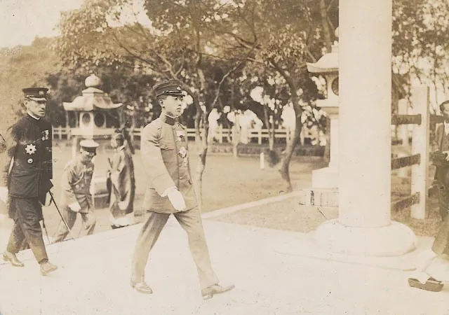
April 17, 1923: Crown Prince Hirohito visits the Taiwanese Shrine. Photo: National Museum of Taiwan History. Public domain via Wikimedia Commons.
Hirohito’s visit that year is directly related to the later shape of Imperial Envoy Street. Starting in 1936, the Japanese began planning the expansion of Imperial Envoy Street because 1940 was the anniversary of "Reiwa Year 2600" (皇紀), and the Taiwanese Shrine needed corresponding expansion; as a processional road for worship, Imperial Envoy Street had to be upgraded2. Construction started on March 30, 1937, and on the morning of March 28, 1941, a completion ceremony was held at the Taiwanese Shrine—the width expanded from 15 meters to 40 meters, becoming a five-lane avenue. It featured asphalt for the central express lane and two side lanes, full tree planting, camphor trees in the median, maple trees inside the sidewalk, mercury streetlights, and underground wiring. The cost was over 1.62 million yen—this budget reflects the road's significance in the imperial narrative during a period of wartime material shortage2.
📝 Curator's Note: The completion ceremony on March 28, 1941, was the last large-scale public construction ceremony in Japanese rule Taiwan. In December that year, Pearl Harbor was attacked and the Pacific War broke out, and the construction budget of the Taiwan Governor-General’s Office was rapidly consumed by war. Imperial Envoy Street was completed at the last moment—40 meters wide, with camphor trees, maple trees, and underground wiring—and then the Japanese left. Today, walking along Zhongshan North Road Section 1 to Section 3, the street trees in the median have been replaced several times, but the 40-meter width planned in 1941 has never changed. The empire collapsed halfway through expanding a road, but the road itself remained, and some of the trees planted in 1941 were not replaced until the 1970s. The ceremonial space of the Japanese is the material heritage left by this city, regardless of whether you like it or not.
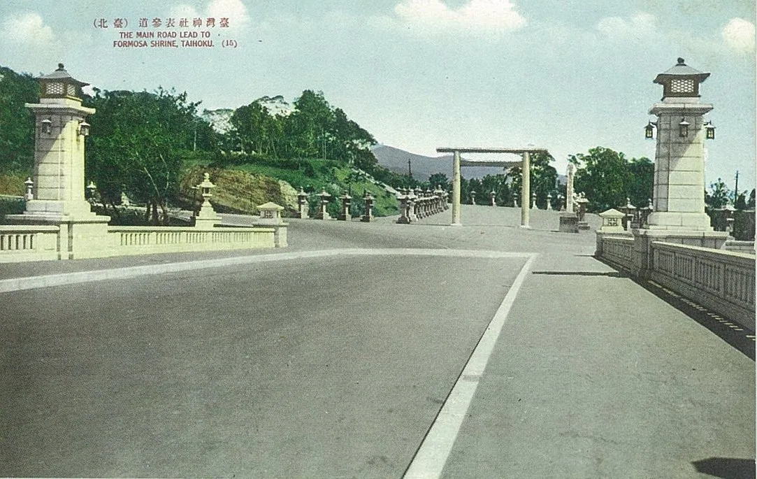
Imperial Envoy Street and Meiji Bridge between 1901 and 1945. Photo: Unknown (Japanese rule hand-drawn postcard). Public domain via Wikimedia Commons.
On October 25, 1945, three months after World War II ended, Ando Rikichi surrendered at the Taipei Public Hall (now Zhongshan Hall) to Chen Yi, a representative of the Republic of China, in his dual capacity as Commander of the Japanese Army's 10th Area Army and Governor-General of Taiwan3. On the day the surrender ceremony concluded, the existence of the Taiwan Governor-General’s Office was terminated.
Imperial Envoy Street also ended. After the ROC government took over, the road was renamed "Zhongshan North Road" to commemorate Sun Yat-sen11, and Meiji Bridge was renamed "Zhongshan Bridge"13. The ceremonial path paved by the Japanese for royalty became a memorial road for the Founding Father—the name changed, but the road remained the same.
The Machine Gun Barrage in 1947
Less than 16 months after Zhongshan North Road was renamed, an event occurred on this street that changed Taiwan's post-war destiny.
On the evening of February 27, 1947, investigators from the Provincial Monopoly Bureau seized tobacco sellers Lin Jiangmai in front of Tianma Teahouse in Dadaochang. During the search, Lin Jiangmai was injured by a gun butt, provoking anger among onlookers—investigator Fu Xuetong fired and accidentally killed bystander Chen Wenxi14. The next day, on February 28, 1947, people began to gather.
Around 1:00 PM, approximately 400–500 people set off from Taipei Station, walking toward the Provincial Executive Yuan (now the Executive Yuan) along Chongqing South Road. The route was Chengde Road $\rightarrow$ Nanjing West Road $\rightarrow$ Dihua Street $\rightarrow$ Minsheng West Road $\rightarrow$ Yanping North Road $\rightarrow$ Beimen $\rightarrow$ Zhongxiao West Road $\rightarrow$ Chongqing South Road $\rightarrow$ Zhongshan South Road $\rightarrow$ Executive Yuan15. Before the group reached the intersection of Zhongshan Road and was stopped by guards, soldiers on the second floor of the Executive Yuan fired machine guns to disperse them, killing at least two people and injuring several others15.
The location of that machine gun barrage—the intersection of Zhongshan Road—is today's intersection of Zhongshan South Road and Zhongxiao West Road, only one street away from Zhongshan North Road Section 1. On the same afternoon, Huang Chaoxin (黃朝琴), Chairman of the Taipei City Council, convened an emergency meeting at Zhongshan Hall (formerly the Public Hall). The next day, on March 1, 1947, the "Tobacco Seizure Blood Case Investigation Committee" was established at Zhongshan Hall, later renamed the "February 28 Incident Handling Committee"16.
📝 Curator's Note: The narrative of the February 28 Incident often focuses on Tianma Teahouse (the first shooting) and the Executive Yuan (the machine gun barrage site). However, the role of Zhongshan Hall is often overlooked. Completed in 1936, the Taipei Public Hall hosted the Japanese surrender ceremony on October 25, 1945, and a meeting that determined Taiwan's trajectory for 38 years post-war on February 28, 1947. This building witnessed two extreme historical moments—from peace to war, from surrender to suppression—in just one year and four months. Today, the square in front of Zhongshan Hall is quiet like a tourist attraction, but the ground beneath your feet is the physical site of Taiwan's two post-war turning points. The starting point of Zhongshan North Road—the intersection of Zhongshan South and North Roads in front of the Executive Yuan—is only 800 meters from Zhongshan Hall and 1.5 kilometers from Tianma Teahouse. This small triangle formed by these three locations is the physical epicenter of Taiwan's post-war tragedy.
The American Troops in 1951
On December 7, 1949, the ROC government announced its relocation to Taiwan. Chiang Kai-shek arrived in Taipei at 8:30 PM on December 1017. From this year onward, Zhongshan North Road became one of the most important axes of the capital city—connecting the military stronghold in Yuan Shan to the north and the Executive Yuan, Presidential Office, and Five Yuan in the south.
But the next transformation of Zhongshan North Road came from a war.
The Korean War broke out on June 25, 1950. President Truman immediately dispatched the Seventh Fleet to the Taiwan Strait and resumed military aid to the ROC. In 1951, the Military Assistance Advisory Group (MAAG) officially arrived in Taiwan18.
Where was the MAAG headquarters located? On Zhongshan North Road Section 3, near Yuan Shan18. The specific location is today's Zhongshan Art Park (the area between Minzu East Road and Zhongshan North Road)18. After the signing of the Mutual Defense Treaty between the U.S. and Taiwan on April 26, 1955, the United States Taiwan Defense Command (USTDC) was established, with its headquarters located in Yuan Shan, Taipei, starting November 1, and this location is today's Taipei Municipal Museum of Art6.
At the peak of American troop numbers, MAAG had 2,347 military personnel18. Throughout the 1950s and 1970s, the area around Zhongshan North Road Section 3 in Taipei concentrated two major U.S. military headquarters—USTDC and MAAG—plus the American Embassy in Taiwan (located at No. 18, Zhongshan North Road Section 2, from 1953)19—and the Japanese-style residences of MAAG families (built around Lane 181, Zhongshan North Road Section 7, starting in 1953)20.
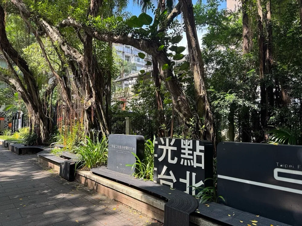
Former U.S. Embassy Residence (now Guangdian Taipei), No. 18, Zhongshan North Road, 2025. Photo: Outlookxp. CC BY 4.0 via Wikimedia Commons.
Over the five kilometers from Zhongshan North Road Section 1 to Section 3, there stood three consecutive American hubs for diplomacy, military, and residence. This street became a "U.S. Concession Area" just six years after being renamed from "Imperial Envoy Street."
Qingguang Market emerged within this context. Located near the intersection of Zhongshan North Road and Shuangcheng Street in 1951, it was originally meant to be called "Zhenguang Market," but because the Tâi-gí pronunciation of Zhenguang sounded like "absurd" (荒唐), it was renamed "Qingguang," meaning "intelligent." The key to the market's formation was the U.S. Post Exchange (P.X.)—all the imported goods (jewelry, clothing, gifts, department stores) flowing out of the P.X. were resold at Qingguang stalls21. Qingguang in the 1950s was where Taipei most quickly encountered "American" material life.
During the August 7–9, 1959 flood, USTDC mobilized three U.S. Navy helicopters to assist with relief efforts. The U.S. Embassy subsequently dispatched the helicopter carrier Seaside Bay from Washington, carrying 21 Sikorsky H-34 helicopters under the codename "Operation Hunger"22. American aid was heavily invested in Taiwan during the post-disaster reconstruction period.
On August 26, 1963, the American Military Club of Taiwan was established on Zhongshan North Road Section 3. From 1965 to 1972, it hosted hundreds of thousands of American soldiers from Vietnam for R&R (Rest and Recuperation)23. During the peak of the Vietnam War, thousands of American soldiers flew from Vietnam to Taipei every week to spend time in the Qingguang Business District on Zhongshan North Road Section 3. The ecosystem of consumption—American Bars, import shops, hostess bars—is a material heritage derived from U.S. military consumption, not the prototype of San Tiao Tong culture in the 1980s.
📝 Curator's Note: Some narratives attribute the "bar culture" of San Tiao Tong to the tradition of "geisha entertainment" during Japanese rule. This narrative reverses the timeline. In Taisho Town in the 1920s, there were no bars. After the ROC government took over in 1945–1950, it became a civil servant dormitory, and there were still no bars. Bars only emerged in these alleyways after the U.S. military arrived in 1951, initially in an American Bar style—jeans, jazz music, martinis, hostesses, dancing. After the Sino-Japanese diplomatic break in 1972 and the U.S. withdrawal in 1979, the Japanese businesses took over these same venues in the 1980s, changing the American Bar style into a Japanese izakaya style and replacing dancing with hostess entertainment—but the material landscape inherited from the military era, not the Japanese rule period. The "Japanese" aspect of San Tiao Tong was only re-imported after the 1980s, not left behind in the 1920s.
The Day in 1972 When Japan Did Not Leave
On the morning of September 29, 1972, in the East Hall of the Great Hall of the People in Beijing, Japanese Prime Minister Tanaka Kakuei and Foreign Minister Date Masayoshi signed the "Sino-Japanese Joint Statement" with Premier Zhou Enlai and Foreign Minister Ji Pengfei to establish diplomatic relations between China (the PRC) and Japan24.
On the same day, the ROC government declared the severance of diplomatic relations with Japan based on the principle of "Han thieves cannot coexist"24. The Japanese embassy in Taipei was quickly converted into the "Association for Cultural Exchange Taipei Office" (a non-official counterpart).
But the Japanese businessmen did not leave.
The 1970s were a period of rapid growth in Japan's economy, following the "Shimbu Boom" and "Iwato Boom." Corporations from Tokyo and Osaka established numerous branches overseas, and Taipei was one of the key destinations for dispatched Japanese businesses7. The diplomatic break did not cause Japanese businesses to withdraw; rather, due to the political vacuum after the diplomatic rupture, private commercial activities required more dense unofficial bases. Where did the Japanese businessmen choose to live in Taiwan? Naturally, they chose the grid area where the Japanese lived during the Taisho Town period—the alleyways on either side of Linssen North Road, east of Zhongshan North Road.
From the perspective of the "relay" between the U.S. military and Japanese businesses: Sino-Japanese diplomatic break (1972) $\rightarrow$ U.S. withdrawal (1979) $\rightarrow$ Japanese business entry (post-1980). This 8-year transition completely rewrote the consumption patterns of the same street. On April 26, 1979, the USTDC held its final flag-lowering ceremony at Yuan Shan headquarters6. On April 28, 1979, Rear Admiral James B. Linder (林德) left Taiwan as the last U.S. military commander6. On May 3, 1979, the last American soldier departed18.
Qingguang Market immediately felt the impact. "After the MAAG and USTDC withdrew in 'Year 68 of the ROC' (1979), Qingguang Market, which had been prosperous for 30 years, gradually declined and lost its former liveliness"21. But the alleyways of San Tiao Tong did not decline—Japanese businesses began taking over when the U.S. military left.
In the Japanese economic bubble era of the 1980s, the number of Japanese businessmen visiting Taiwan exploded. Japanese bars, izakayas, Japanese restaurants, and karaoke establishments flourished in the Linssen North Road area; "at its peak, over 400 shops operated simultaneously there"7. In March 1989, the first KTV store opened on Linssen North Road, expanding to five branches by the end of that year25. The late 1980s and early 1990s in Linssen North Road were one of the birthplaces of Taiwan's KTV industry.
The term "San Tiao Tong" itself—Japanese jō (alley) and dōri (street)—was fixed during this period. Before the 1980s, Taipei residents referred to this area as "Linssen North Road Alley"; only after the 1980s did they commonly use Japanese numbering like "Qi Tiao Tong," "Ba Tiao Tong," or "Jiu Tiao Tong."
📝 Curator's Note: On September 29, 1972, when the Sino-Japanese Joint Statement was signed, the Japanese embassy in Tokyo withdrew from Taipei, but most Japanese businessmen did not leave. Why? Because Japan's economic momentum in the 1970s came from exports—semiconductors, automobiles, and electronics needed overseas markets, and Taiwan was the closest geographical and cultural option. After the diplomatic break, bilateral relations gave up diplomatic parity but gained a space for continued free movement at the economic level. The same logic applies to the Sino-American diplomatic break in 1979—the American soldiers left, but through the Taiwan Relations Act that year, unofficial relations between the U.S. and Taiwan were maintained until today via AIT. Taipei was a material laboratory for this "diplomatic rupture yet continued interaction" model in the 1970s and 80s. The two parcels of land on Zhongshan North Road Section 3 (USTDC + MAAG) became museums and art parks—military land downgraded to cultural land. But the Japanese businesses continued in the San Tiao Tong alleyways; this transition is invisible at the street level.
The Renaming in 1996
Before 1996, the road in front of the Presidential Office was called "Jieshou Road"—it was renamed in 1946 to celebrate Chiang Kai-shek's 60th birthday26. This same road continued north from Zhongshan North Road Section 1, then Section 2, and Section 3, all the way to Yuan Shan. This 6-kilometer north-south axis, from Jieshou Road to Zhongshan North Road, was the most concentrated material landscape of political power in Taiwan.
On March 21, 1996, Chen Shui-bian (陳水扁), who had just been elected Mayor of Taipei for one year, announced that "Jieshou Road" would be renamed "Kaida Gran Avenue"26. The reason for the renaming was clear—Jieshou Road commemorated an individual leader, while Kaida Gran Avenue honored the indigenous peoples of the Taipei Basin26.
This act of renaming is a symmetrical structure in Zhongshan North Road's history. In 1923, Crown Prince Hirohito rode along Imperial Envoy Street from Taipei Station, representing the highest ceremonial space of the Japanese Empire. In 1996, Chen Shui-bian named the southern end of this road to commemorate indigenous peoples—a counter-action by democratizing Taiwan against colonial history. 73 years ago, the Emperor of Japan was accepted for worship at the end of this road; 73 years later, the other end of the road was named after the indigenous people who lived there before the Japanese arrived.
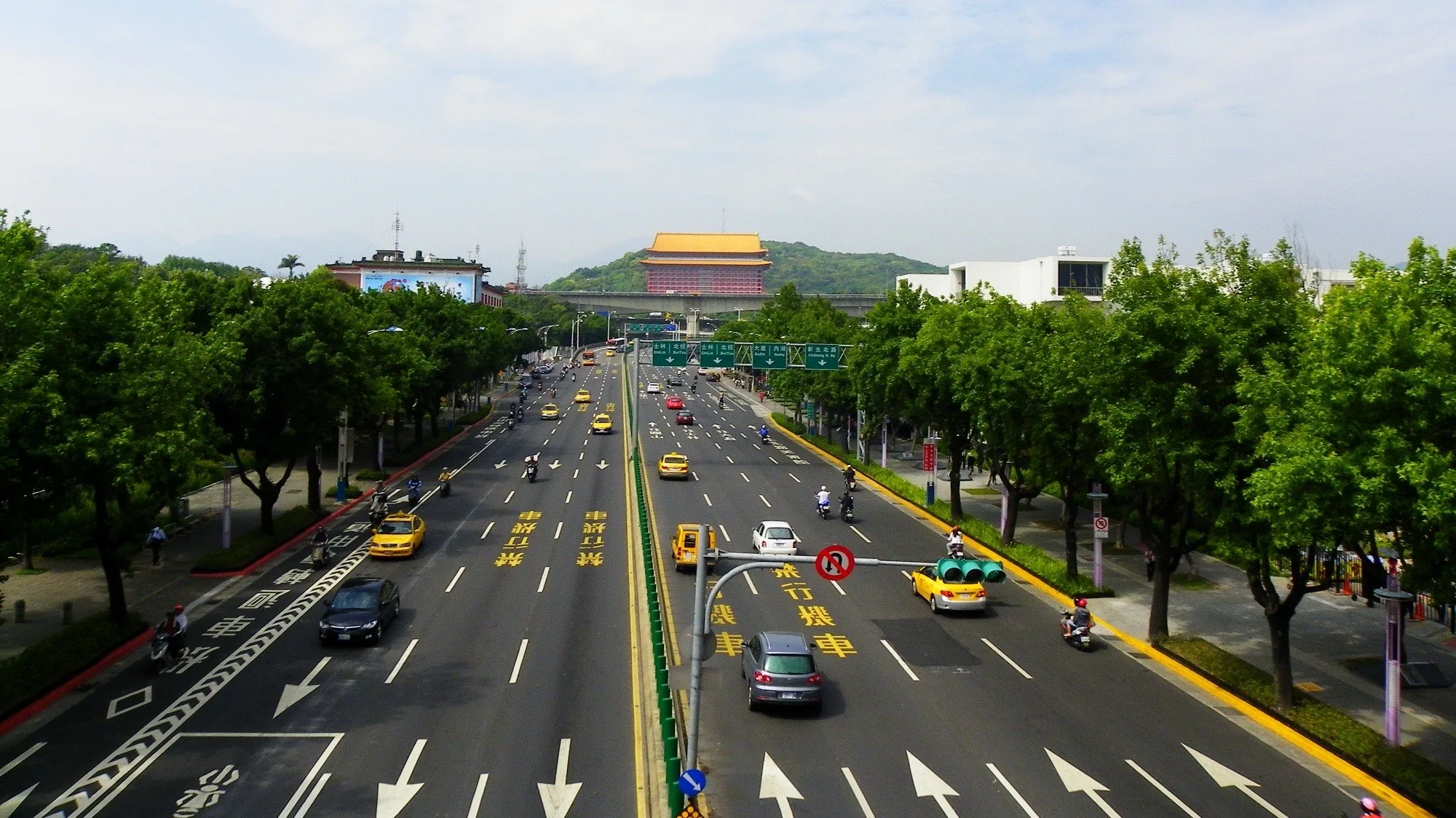
View looking north from the Expo pedestrian bridge on Zhongshan North Road Section 3, April 25, 2011. Photo: Xuan Shi Sheng. CC BY-SA 3.0 via Wikimedia Commons.
1996 was also a key year for major transformations at both ends of Zhongshan North Road. The former U.S. Embassy residence was slated for demolition before 1995, and the Ministry of the Interior designated it as a municipal historic site on February 20, 199719. On November 10, 2002, the former U.S. Embassy was renovated and reopened as "Guangdian Taipei," operated by the Taiwan Film Culture Association led by Hou Hsiao-hsien (侯孝賢), with hardware restoration sponsored by the TSMC Cultural Foundation27. The Victorian mansion, which had been idle for 18 years after the ROC severed diplomatic relations with the U.S., became a home for Taiwanese film culture.
On December 20, 2002, Zhongshan Bridge (formerly Meiji Bridge) was demolished, cut into 435 pieces and stored at the original site of Zaichun Swimming Pool13. The reinforced concrete arch bridge, completed in 1933, was once one of the "Eight Sights of Taiwan"13, but after surviving for 69 years, it was demolished during Mayor Ma Ying-jeou's tenure under the pretext of "obstructing Keelung River flood control." The final physical link from Imperial Envoy Street to Zhongshan North Road was severed.
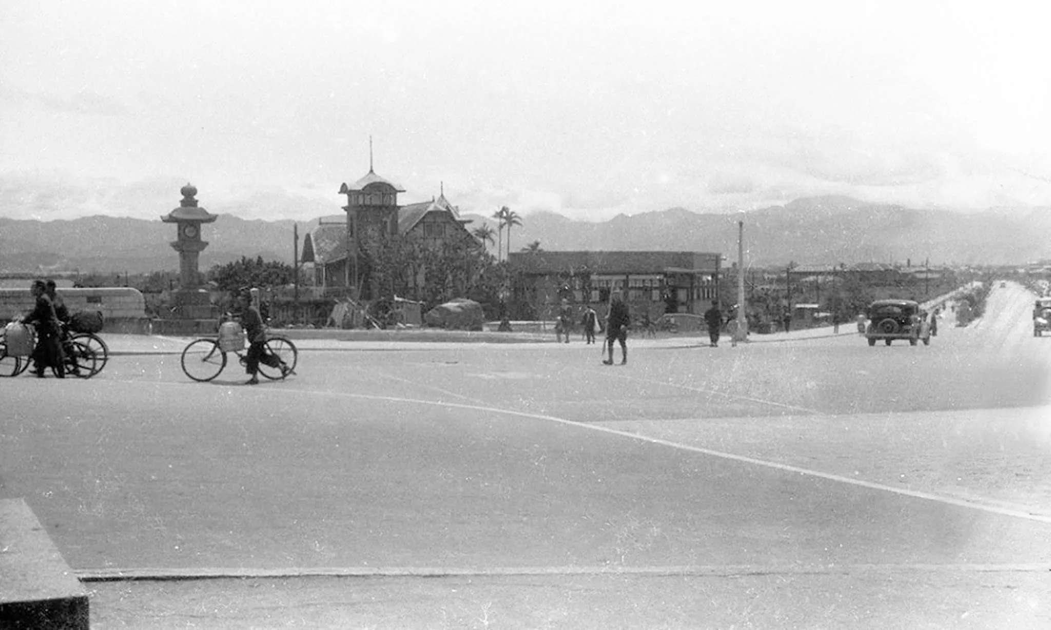
Scenery near Meiji Bridge during Japanese rule. Photo: Li Huozeng. Public domain via Wikimedia Commons.
Three Places, Traces of Three Empires
After tracing the story of San Tiao Tong culture on Zhongshan North Road, local residents will not take you to take photos at the Grand Hotel Yuan Shan or go drink at Din Tai Fung. They will take you to see three places, each corresponding to a trace of an empire.
Guangdian Taipei (No. 18, Zhongshan North Road Section 2). This Victorian white mansion, built in 1926, was upgraded to the U.S. Consulate General in Taipei in 1949 and became the U.S. Embassy in 1953. After the diplomatic break in 1979, it lay idle for 18 years, becoming a municipal historic site in 1997, and was converted into Guangdian Taipei Cinema in 20021927. Today, Guangdian Taipei screens 4 to 6 art films daily, and the first floor houses Wool & Flower Coffee Lounge. Sitting on the second-floor balcony, you see the ceaseless traffic on Zhongshan North Road Section 2; under your feet is the floor where American diplomats ate breakfast from 1953 to 1979. The transformation from an American political outpost to a cultural hub for Taiwan is more concrete than any textual description.
Grand Hotel Yuan Shan (No. 1, Zhongshan North Road Section 4, Yuan Shan). This site was the Taiwanese Shrine (later upgraded to the Taiwanese Grand Shrine) from 1901 to 1944, and it was demolished by Japanese aircraft (allegedly a friendly fire incident) in 194428. On May 10, 1952, Chiang Ching-kuo's wife, Soong Mei-ling (蔣宋美齡), led the "Taiwan Benevolent Association" to take over the former Taiwanese Shrine site and rebuild it as the "Taiwan Grand Hotel," later renamed "Grand Hotel Yuan Shan"28. The hotel was fully completed in 1963, and the 14-story Chinese palace-style building designed by Yang Zhuocheng (楊卓成) was completed in 1973—from this time on, the Grand Hotel Yuan Shan became one of Taipei's most iconic buildings. From the site of the highest deity of the Japanese Empire to a welcoming gateway for the ROC, the same piece of land transitioned from worship to hotel, but the meaning of "highest rank" never disappeared.
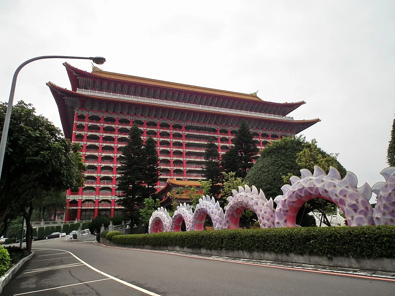
Grand Hotel Yuan Shan, March 11, 2012. Photo: lienyuan lee. CC BY 3.0 via Wikimedia Commons.
Taipei Municipal Museum of Art (No. 181, Zhongshan North Road Section 3). From November 1, 1955, for 30 years, this was the headquarters of the USTDC—from 1955 to 1979, this site was the command center of U.S. forces in the Pacific theater; Major Linder issued the flag-lowering order on April 26, 1979, from an office here6. After the U.S. military withdrew in 1979 and the land lay idle for several years, the Taipei Municipal Museum of Art officially opened on December 24, 1983, on the former USTDC site. The transformation from a military command center to Taiwan's first public modern museum explains the direction of post-1979 Taiwanese social transition more clearly than anything else: from a military periphery to a cultural subject.
After visiting these three places, you understand the true texture of Zhongshan North Road. Beneath the red tiles of the Grand Hotel Yuan Shan is the foundation of the Taiwanese Shrine from 1901 to 1944; the white wooden shutters of Guangdian Taipei are from the American diplomatic office from 1926 to 1979; beneath the light-colored brick walls of the North American Museum (北美館) is the U.S. military command base from 1955 to 1979. A 5-kilometer road, three places corresponding to the material traces of three foreign empires, each one being "rebuilt after the previous empire left."
📝 Curator's Note: These three places share a commonality—they are all cultural spaces today (hotel + cinema + museum). Before 1979, this street was too dense with political symbols—shrine, embassy, military command center. But in the 40 years after 1979, all these political outposts were transformed into cultural hubs. This is not a coincidence. After the Sino-American diplomatic break in 1979, Taiwan faced the dilemma of "no diplomacy and no membership in international organizations," making cultural subjectivity (film, art, literature, design) one of the only channels for an island to speak out. The opening of the North American Museum in 1983 and Guangdian Taipei in 2002 are material manifestations of this direction. Zhongshan North Road changed from a "ceremonial road," a "diplomatic road," and a "military road" into a "cultural road," reflecting Taiwan's overall trajectory of "losing diplomacy but building culture" in the post-war decades.
The Same Road, The Same Grid, Different Guests
At nine PM, we return to the lanterns of San Tiao Tong.
On April 17, 1923, Crown Prince Hirohito set off from Taipei Station on a carriage, with Taiwanese natives and mainland Japanese people in kimono standing along the roadsides, bowing to the prince in the carriage. The prince did not know that this road would be renamed "Zhongshan North Road" 22 years later, nor did he know that 88 years later, it would be crowded with Japanese businessmen in suits entering izakayas.
On the afternoon of February 28, 1947, at 1:30 PM, over 400 Taipei citizens walked south from the Zhongshan Road intersection. They did not reach the square of the Executive Yuan because the group scattered after being stopped by machine gun fire. A few people died; no one clearly remembers the exact number that day. Three weeks later, General Pang Meng-zhi (彭孟緝) of the Kaohsiung Fortress ordered a crackdown, and martial law began across the island. The distance from the entrance of Zhongshan Hall to the intersection of Zhongshan North Road was only 800 meters.
On November 1, 1955, the USTDC officially took up its headquarters in Yuan Shan. The 2,347 military personnel and families of MAAG and USTDC moved into the vicinity of Zhongshan North Road Section 3 and the Tianmu American residences. Qingguang Market flourished, with imported goods flowing from the P.X. to Taiwanese consumers. Zhongshan North Road Section 3 overnight became a "U.S. Concession Area."
On April 26, 1979, Major Linder lowered the Stars and Stripes in Yuan Shan. Later that day, he wrote a letter to the Pentagon reporting the withdrawal plan; the coffee cup on his desk bore the U.S. Navy insignia—that cup was brewed with beans brought by American aid.
In March 1989, the first KTV store opened on Linssen North Road. In September of that year, Kimi ga Iru dake de (君がいるだけで) and Tadaima were listed alongside songs by Luo Dayou (羅大佑) and Wu Boi (伍佰). Japanese businessmen and young Taiwanese people ordered the same song in the same private room.
On the evening of November 26, 2021, Netflix's Huadeng Chushuang premiered its first season. Luo Yu-nong (羅雨儂), played by Lin Xinru, walked into the "Light" hotel in Qi Tiao Tong, set against the backdrop of San Tiao Tong in 1988. After the drama aired, the alleyways were packed with young people every Saturday night wanting to take photos—they did not know that the ground beneath their feet was a layering of Taisho Town (1922), the U.S. Concession Area (1951), and the birthplace of KTV (1989).
On a Friday evening in 2026, at nine-thirty PM, a Japanese businessman aged 50 emerged from Toruchu's wooden gate deep in San Tiao Tong. He lit a cigarette, glanced at the Kanji and Katakana signs, and walked toward Zhongshan Metro Station. His company was in Neihu Science Park, but every Friday evening he would take a taxi to San Tiao Tong for two drinks because the Toruchu there tasted exactly like the one in Nihonbashi, Tokyo. The sake he had just drunk was from Niigata, but the cup was made by a Taiwanese ceramic artist. He had been in Taipei for eight years, but the curtain of this alley has been here since the generation of Japanese businesses who came to Taipei in the 1980s.
✦ The name "Imperial Envoy Street" never completely disappeared. It was renamed "Zhongshan North Road" in 1945 and the southern end was renamed "Kaida Gran Avenue" in 1996—but the 40-meter width, the placement of camphor and maple trees, and the grid layout of San Tiao Tong alleyways were all determined by the expansion project from 1937 to 1941. A road can change its name three times, but the material structure of a road never updates.
The core contradiction of Zhongshan North Road is this: The ceremonial path to the shrine, paved starting in 1898, walked by Crown Prince Hirohito in 1923, and expanded into a 40-meter five-lane avenue from 1937 to 1941, was renamed to commemorate the Founding Father of the ROC post-war; it became a U.S. Concession Area in the 1950s; and after the U.S. military left in 1979, the Japanese ultimately took over this street—but this time they were not imperial envoys, but businessmen dispatched from companies like SONY, Panasonic, and Itochu to Taipei.
What others see as Zhongshan North Road is the central axis between the Grand Hotel Yuan Shan and the Presidential Office. What locals live on is the overlapping axis of Section 3: the shape of Imperial Envoy Street in 1923, the bar locations of the U.S. Concession Area from 1951–1979, and the San Tiao Tong curtains taken over by Japanese businesses after the 1980s. Three foreign empires successively layered one another; each change brought a new name, but the same 5-kilometer road remained the same 5-kilometer road.
If you pass Guangdian Taipei on Zhongshan North Road Section 2 next time, stop for 30 seconds. Looking north from Guangdian Taipei is the former U.S. Embassy (removed in 1979); another 1.5 kilometers north to the Zhongshan Art Park is the MAAG (removed in 1979); and another 500 meters north to the Taipei Municipal Museum of Art is the USTDC (removed in 1979). These three locations form a line along Zhongshan North Road. One kilometer further north is the Grand Hotel Yuan Shan—the site of the Taiwanese Shrine demolished in 1944. The Japanese left 81 years ago, and the Americans left 47 years ago, but tonight at nine PM, there are still Japanese businessmen mixing laughter with Taipei residents on this street.
Further Reading:
- Taipei City: Three Times in One City, Longshan Temple Watching 101 in 2004 — The location of Zhongshan North Road within District 12, juxtaposing the timelines of Wanhua, Dadaochang, and Xinyi.
- Dadaochang: A Street of 800 Meters Housing Three Centuries — A sibling historic district from the same batch, a downtown that rose during the tea era in 1860, where the first shot of the February 28 Incident occurred at No. 189 Nanjing West Road in 1947.
- Wanhua: The Busiest Place in Qing Dynasty Taipei, Now Taiwan's Oldest District — A sibling historic district from the same batch, representing a different pattern of urban formation compared to the "Japanese rule planning" style of San Tiao Tong culture.
- Ximen Town: An Entertainment Street Built by the Japanese in 1896, Still Taipei's Youngest Street After 130 Years — A sibling historic district from the same batch, a foreign entertainment area outside the city like San Tiao Tong, but following a completely different subculture path.
- Taiwanese Tea Ceremony and Life Aesthetics — The mutual influence between Japanese aesthetics in San Tiao Tong culture and the post-war Taiwanese tea ceremony revival movement.
- February 28 Incident — On the afternoon of February 28, 1947, crowds marched to the Zhongshan Road intersection and were machine-gunned by guards; Zhongshan Hall convened an emergency meeting on the same day to form the incident handling committee.
- Taiwanese Street Trees — How the colonial planning logic of "wide roads with neat rows of trees" extended from the tree planting theory established in 1898 to the predecessor, Imperial Envoy Street.
- Beitou Hot Spring Town — The two divergences in Taipei's post-war sex industry landscape: the prohibition of prostitution in Beitou in 1979 versus the city-wide ban on licensed prostitutes in 1997, compared to San Tiao Tong culture on Linssen North Road.
Image Sources
This article uses 6 public domain / CC licensed images, all cached at public/article-images/geography/ to avoid hotlinking source servers:
- Section 3 Zhongshan North Road Birdview from Overpass — Photo: Xuan Shi Sheng, April 25, 2011, CC BY-SA 3.0
- A historical photo of Crown Prince Hirohito visiting the Taiwanese Shrine in 1923 — Photo: National Museum of Taiwan History / Unknown author, April 17, 1923, Public domain
- View of main road to Taiwan Grand Shrine — Photo: Unknown (Japanese rule hand-drawn postcard), 1901–1945, Public domain
- View near the Taihoku Meiji Bridge — Photo: Li Huozeng, 1895–1945, Public domain
- Former U.S. Embassy Residence on Zhongshan North Road — Photo: Outlookxp, August 2, 2025, CC BY 4.0
- Taipei Grand Hotel Yuan Shan - panoramio — Photo: lienyuan lee, March 11, 2012, CC BY 3.0
References
- Taiwan Travel Guide — Wikipedia — Records of Crown Prince Hirohito's visit to Taiwan from April 12–27, 1923, detailing the itinerary starting from Taipei Station along Imperial Envoy Street to the Taiwanese Shrine in Yuan Shan, accompanied by royalty such as Prince Nobukawa Miyanehide and Prince Fushimi Hiakiyo.↩23
- Imperial Envoy Street — Wikipedia — Detailed records of the expansion project: "The widening ceremony was held on March 30, 1937, and the completion ceremony was held at the Taiwanese Shrine at 11:00 AM on March 28, 1941." The road, expanded to a 40-meter five-lane avenue with asphalt for the central express lane and two side lanes, full tree planting, camphor trees in the median, maple trees inside the sidewalk, mercury streetlights, and underground wiring, cost over 1.62 million yen. The motivation for expansion since 1936 was related to the commemoration of Japan's Year 2600 (1940) and the corresponding expansion of the Taiwanese Shrine.↩234
- Taiwan Liberation — Wikipedia — Complete records of the surrender ceremony held at the Taipei Public Hall (now Zhongshan Hall) on October 25, 1945, where General Ando Rikichi surrendered to Chen Yi, a representative of the Allies and the ROC.↩2
- U.S. Military Advisory Group (ROC) — Wikipedia — Official records of the MAAG's establishment and arrival in Taiwan in 1951, including key data such as the number of U.S. military personnel stationed there in 1951, and that the embassy and commander residences were located near Zhongshan North Road.↩
- Taipei Magazine, November 106, Issue 598—U.S. Military Brings Leisure and Business Opportunities to Qingguang Business District — Official magazine of the Taipei City Tourism Bureau detailing the rise of Qingguang Market as a leisure area for American soldiers during the U.S. military advisory period in the 1940s, making it a hub for imported goods from the P.X.↩
- U.S. Taiwan Defense Command — Wikipedia — Complete history of USTDC: establishment of the "Taiwan Liaison Center" on April 26, 1955; renaming to "U.S. Taiwan Defense Command" on November 1, 1955; headquarters located in Yuan Shan, Taipei (current site is the Taipei Municipal Museum of Art); the final flag-lowering ceremony held on April 26, 1979; and Major Linder leaving on April 28, 1979, as the last military officer to leave.↩23456
- From Huadeng Chushuang to See San Tiao Tong Culture in 1988! Why are Japanese Hotels All Open in Zhongshan District? — Urban Studies — A special article in Urban Studies by Yuan-jen Magazine detailing the rise of San Tiao Tong culture: large-scale entry of Japanese businesses after the 1970s, the influx of Japanese companies to Taipei during Japan's economic recovery in the 1980s, and the complete transformation record of over 400 Japanese bars operating simultaneously in Linssen North Road.↩23
- San Tiao Tong Business District — San Tiao Tong Map — + How to Divide San Tiao Tong — Liberty Times — A complete reference table for the specific alley numbers from Yi Tiao Tong to Shi Tiao Tong: Yi Tiao Tong is Citizen Avenue; Er Tiao Tong is Lane 33 of Zhongshan North Road Section 1; San Tiao Tong is Lanes 53 of Zhongshan North Road Section 1 and 67 of Linssen North Road; Si Tiao Tong is East Chang'an Road Section 1; Wu Tiao Tong is Lanes 83 of Zhongshan North Road Section 1 and 85 of Linssen North Road; Liu Tiao Tong is Lanes 105 of Zhongshan North Road Section 1 and 107 of Linssen North Road; Qi Tiao Tong is Lanes 121 of Zhongshan North Road Section 1 and 119 of Linssen North Road; Ba Tiao Tong is Lanes 135 of Zhongshan North Road Section 1 and 133 of Linssen North Road; Jiu Tiao Tong is Lanes 138 and 145 of Linssen North Road; Shi Tiao Tong is Lane 159 of Linssen North Road↩2
- Huadeng Chushuang (TV Series) — Wikipedia — Complete production records of the Netflix original series Huadeng Chushuang, which premiered on September 11, 2020; wrapped up on January 27, 2021; released its first season on November 26, 2021; starring Lin Xinru, Yang Youning, and Yang Jin-hwa; with the entrance of the "Light" HIKARI hotel shot at Sugar Bar in Qi Tiao Tong and filming locations on Lane 133 of Linssen North Road set against San Tiao Tong culture in Taipei in 1988.↩
- Taisho Town (Taipei) — Wikipedia + Understanding Taisho Town and Gesho Town during Japanese Rule — Urban Renewal Research and Development Foundation — Taisho Town was developed by Taiwan Building Co., Ltd. in 1912; in the town renaming of 1922, it was divided into Taisho Town (East side) and Gesho Town (West side along Imperial Envoy Street), covering the area east of Zhongshan North Road, west of Xinsheng North Road, south of Nanjing East Road, and north of Citizen Avenue. It followed a Kyoto chessboard pattern, where East-West streets were called "Tong" and North-South streets were called "Jin," making it Taiwan's first private high-modernized community with complete records of detached and Westernized mixed residences.↩2
- Zhongshan North Road (Taipei) — Wikipedia — History of Zhongshan North Road naming: from Imperial Envoy Street during Japanese rule (from Kashan Town to Meiji Bridge) to the post-war renaming "Zhongshan North Road" to commemorate Sun Yat-sen, a complete road record spanning Zhongzheng, Zhongshan, and Shilin Districts.↩2
- Taiwan Grand Shrine — Wikipedia — The Taiwanese Shrine was completed in 1901 at the foot of Jian Tan Mountain in Yuan Shan; the chief priest, Prince Nobukawa Miyanehide (who led the Konoe Division to conquer Taiwan in 1895 and died of illness in Tainan that year), served as the Chief Protector of Taiwan and held the rank of Kanpei Taisha (highest-ranking shrine); it was upgraded to a Grand Shrine and enshrined Amaterasu in 1944, and demolished in 1945.↩2
- Zhongshan Bridge (Taipei) — Wikipedia — The second generation reinforced concrete arch bridge of Meiji Bridge started construction on January 25, 1930; completed on March 20, 1933; with a total length of 120 meters and a width of 17 meters (10m roadway + 3.5m sidewalk $\times$ 2); featuring granite railings and bronze lampposts; renamed Zhongshan Bridge post-war; demolished on December 20, 2002, cut into 435 pieces and preserved at the original site of Zaichun Swimming Pool.↩23
- Tianma Teahouse — Wikipedia — The source text of the Lin Jiangmai seizure incident in 1947: "Six investigators from the Taipei Branch of the Provincial Monopoly Bureau seized private tobacco from a 40-year-old widow, Lin Jiangmai, who had children, in front of Tianma Teahouse." Investigator Fu Xuetong accidentally killed bystander Chen Wenxi during the confusion. The location is opposite the Taipei Fa Zhu Temple on No. 189 Nanjing West Road, Taipei City today.↩
- February 28 Incident Database—Executive Yuan — The route of the crowd march on the afternoon of February 28, 1947: four routes converged at the Executive Yuan along Zhongshan South Road after starting from the smoke markets in Taipei's Houhu Station, Dadaochang, Wanhua, and student groups. At 1 PM, they were stopped by guards at the intersection of Zhongshan Road; soldiers on the second floor of the Executive Yuan machine-gunned them, killing at least two people and injuring several others.↩2
- Forgotten Sites of the February 28 Incident: Zhongshan Hall in Taipei — StoryStudio — The key role of Zhongshan Hall in the February 28 Incident: on February 28, 1947, the Taipei City Council convened an emergency meeting at Zhongshan Hall; on March 1, 1947, the "Tobacco Seizure Blood Case Investigation Committee" (later renamed the "February 28 Incident Handling Committee") was established there.↩
- National Archives of Taiwan — ROC Relocation — Official archives: The Presidential Order announced the government's relocation to Taipei on December 7, 1949; Chiang Kai-shek arrived in Taipei at 8:30 PM on December 10, 1949, from Chengdu; official records show approximately 1.2 million people followed the central government and military into Taiwan from mainland China between 1949 and 1950.↩
- U.S. Military in Taiwan — Wikipedia — Complete history of U.S. forces in Taiwan: The Korean War broke out on June 25, 1950; the MAAG arrived in 1951; Washington announced the cancellation of the MAAG name on February 22, 1979; the last American soldier left on May 3, 1979. Both USTDC and MAAG headquarters were located in the Yuan Shan section of Zhongshan North Road (the current site of the Taipei Municipal Museum of Art for USTDC, and the grounds of the MAAG command post are today's Zhongshan Art Park).↩2345
- Former U.S. Embassy Residence — Wikipedia — Complete architectural history: The former U.S. Embassy residence at No. 18, Zhongshan North Road Section 2, was completed in 1926; upgraded to the U.S. Consulate General in Taipei in 1949; became the U.S. Embassy in 1953; lay idle after the Sino-American diplomatic break in 1979; designated as a municipal historic site for demolition planning in 1995; designated by the Ministry of the Interior on February 20, 1997; and reopened as "Taipei Home" (including Guangdian Taipei Cinema) after renovation in 2002.↩23
- Yangmingshan U.S. Military Residences — Wikipedia — Complete construction records: The MAAG planning team circled above Taipei City by helicopter in 1951; Yangmingshan Shanzaihou and Tianmu (the end of Zhongshan North Road Section 7) were finally selected as sites for American military families; the Tianmu residences began construction in 1953, including No. 23, Lane 181, Zhongshan North Road Section 7.↩
- Strolls through Old Taipei: Stories of Qingguang Business District — Great Circulate — Complete history of the rise and decline of Qingguang Market in 1951 (Year 40 of ROC): originally meant to be "Zhenguang Market" but changed to "Qingguang" because Zhenguang sounded like "absurd"; it rose as a leisure area for American soldiers during the U.S. military advisory period in the 1940s, gathering many imported goods shops (jewelry, clothing, gifts, department stores); Qingguang Market gradually declined after the MAAG and USTDC withdrew in 1979.↩2
- August 7–9 Flood — Wikipedia — Complete rescue records: During the August 7–9, 1959 flood, USTDC mobilized three U.S. Navy helicopters for relief; Washington ordered the helicopter carrier Seaside Bay to carry 21 Sikorsky H-34 helicopters to Taiwan under the codename "Operation Hunger."↩
- U.S. Military in Taiwan — Military Club Entry — Complete record: The American Military Club of Taiwan was established on August 26, 1963; from 1965 to 1972, it served as a leisure area for hundreds of thousands of American soldiers from Vietnam for R&R in the Zhongshan North Road Section 3 location.↩
- Sino-Japanese Joint Statement — Wikipedia — Complete diplomatic event records: The signing ceremony at the Great Hall of the People in Beijing on the morning of September 29, 1972; Japanese Prime Minister Tanaka Kakuei and Foreign Minister Date Masayoshi representing Japan; Premier Zhou Enlai and Foreign Minister Ji Pengfei representing China; the ROC declaring severance of diplomatic relations with Japan based on the principle of "Han thieves cannot coexist" on the same day.↩2
- KTV Company — Wikipedia — Complete history of the KTV industry: The first KTV store opened in Linssen North Road, Taipei City, in March 1989; founder Liu Ying originally ran a videotape rental shop; it expanded to five branches by the end of that year; this record covers the rise of the "KTV" new model, which combined MTV and karaoke after American MTV operators withdrew following the U.S. Special 301 Report in 1988.↩
- Kaida Gran Avenue Renaming History — Taipei Peace Foundation — Official records: On March 21, 1996, Mayor Chen Shui-bian renamed "Jieshou Road" (which was renamed in 1946 to celebrate Chiang Kai-shek's 60th birthday) to "Kaida Gran Avenue," symbolizing recognition of Taiwan's indigenous history and culture. The predecessor to Jieshou Road during the Qing dynasty was called "Taipei Prefecture East Gate Street."↩23
- Guangdian Taipei Cinema — Wikipedia — Complete cultural space record: Guangdian Taipei (Taipei Home) officially opened on November 10, 2002; operated by the Taiwan Film Culture Association led by Hou Hsiao-hsien; hardware restoration sponsored by the TSMC Cultural Foundation; primarily operates as an art cinema (4–6+ screenings daily), including Wool & Flower Coffee Lounge and Guangdian Life Creative Store.↩2
- Grand Hotel Yuan Shan — Wikipedia — Complete history of Grand Hotel Yuan Shan: The original site was the Taiwanese Shrine, which was demolished in 1944; on May 10, 1952, it was taken over and rebuilt as "Taiwan Grand Hotel" by the Taiwan Benevolent Association led by Soong Mei-ling; later renamed "Grand Hotel Yuan Shan"; Kong Lingwei was the first general manager; the hotel was fully completed in 1963; the 14-story Chinese palace-style building designed by Yang Zhuocheng was completed in 1973, becoming a Taipei landmark.↩2