
30-second overview: In 1908, the first phase of harbor construction at Dagou Port began; by 1970, the Kaohsiung Port Container Terminal No. 1 was completed. What separates these dates is not a series of naturally occurring years, but a timeline of railways, sugar factories, bananas, customs, warehouses, factories, military presence, and urban residents pulling in different directions. Kaohsiung Port allowed the products of southern Taiwan to reach the world faster, but it also saw the land by the port renamed time and again. Today, walking along Penglai Road, the red-brick Port History Museum and the vacant banana sheds still remind people: the history of a port never belongs only to ships and cargo1.
A Small Port with a Narrow Entrance
In nineteenth-century texts, Dagou Port was not a natural good harbor suitable for large ships. Historical materials compiled by the Archives and Technology Development Council describe it as originally a small fishing harbor used for seasonal black pomfret fishing and seeking shelter. The entrance featured large rocks, the waterway was narrow, and the harbor suffered from shallow depths and siltation problems1. Local history research adds that the area now known as Yancheng was once salt fields, and life around Qijin, Shaochuantou, and the harbor was initially composed of fishing, salt production, and small-scale trade, rather than being predetermined by a modern port plan2.
In 1860, following a defeat, the Qing government opened Dagou and other ports to trade, making sugar an important commodity for foreign merchants to watch in southern Taiwan. The British established a vice-consulate in Dagou in 1864, not because the port was already mature, but because merchants believed it still had the potential to be developed into a port2. This distinction is worth preserving: a port's value is determined not only by natural conditions, but also by the bets placed by merchants, governments, and engineers on the future.
Kaohsiung Port is often remembered as "Taiwan's largest port," but looking back from the early landscape, this result was not inevitable. The harbor had to be measured, dredged, and reclaimed, and then connected by railways and storage. Each engineering project transformed the original sea, salt fields, fish ponds, and settlements into new public or industrial spaces. A port does not wait by the sea for cargo; it is a city organ manufactured by institutions and engineering.
Railways First Turned the Port into an Export Machine
After Japan took control of Taiwan, the sugar industry became a key pillar of the colonial economy. A problem quickly emerged: how to transport sugar from southern Taiwan back to Japan? If all cargo had to be routed through Keelung for export, the time and cost would be unreasonable. Local history articles record that around 1900, the Governor-General's Office began investigating Dagou Port, viewing the connection of the southern end of the Cross-Island Railway to the port as the solution. Between 1904 and 1907, land reclamation and railway extension simultaneously changed the scale of the port area2.
In 1908, the Cross-Island Railway was fully opened, and the same year, the Dagou harbor construction project was launched. The Archives and Technology Development Council notes that the first phase of harbor construction laid the foundation for modern Kaohsiung Port between 1908 and 1912, establishing a new intermodal relationship between railways, the port, and the export of rice and sugar1. This "intermodal" connection is not an abstract noun: sugarcane from the fields, sugar from factories, freight cars on trains, and dockworkers on the docks were all placed into the same timetable.
Reclamation also changed the residential order of the city. Local historical data describes Hamaxing as derived from the Japanese pronunciation of the waterfront line, pointing to the relationship between the coastal railway and the newly created land. The new urban district featured grid-like streets, electricity, streetlights, sewers, and public markets, becoming a concentration point for Japanese administrative and commercial activities2. But modernization was not light evenly sprinkled on everyone. The Japanese held more political and economic resources, while immigrants from Penghu and the coastal areas of Tainan mostly engaged in labor work. The port attracted population, but also placed different ethnic groups into unequal spaces.
| Engineering or Institution | Capabilities Gained by the Port | Lives Rearranged |
|---|---|---|
| Cross-Island Railway and Port Line | Allowed sugar, rice, and daily necessities to reach the dock quickly | Cargo routes passed through existing settlements and the coast |
| First Phase Harbor Construction | Dredged channels, improved ship entry and exit | The sea, salt fields, and new land were re-zoned |
| Port and Customs Authorities | Allowed cargo to be taxed, inspected, and managed | The port became the frontline of state institutions |
| New Urban Districts like Hamaxing | Concentrated commerce, administration, and transport | Different immigrants lived in stratified layers based on resources and occupation |
This also explains why the story of Kaohsiung Port cannot be written solely as "the Japanese built the port, and Taiwan was thus modernized." Harbor construction indeed brought transport efficiency, but it simultaneously concentrated land, labor, and decision-making power into a new port-city mechanism. As the port expanded, who could approach the dock, who could work by the port, and whose houses would be included in the new urban district were all part of modernization.
Taxes and the Sea in the Red-Brick Port History Museum
Next to Pier 3 of the Penglai Commercial Port Area, the Kaohsiung Port History Museum is a two-story red-brick building. The Kaohsiung City Cultural Assets Network records that it was founded in 1916 and completed in 1917, initially serving as the office of the Taiwan Governor-General's Finance Bureau stationed at Dagou Port, responsible for collecting consumption tax on sugar. It later went through various agencies including customs, maritime affairs, and port management, and was only converted into a port history museum after renovation in 19973 4. The National Cultural Heritage Network confirms its construction started in December 1916 and was completed in 1917, noting its Western classical-style brick exterior and status as a historical building5.
The most interesting aspect of this building is not just the red bricks and arched windows, but how it fixed the "invisible" work of the port into a specific space. Before ships arrived, the value of cargo had to be registered, classified, estimated, and taxed. Sugar did not simply disappear from the production site into the sea; it was redefined by state agencies at the port. The fact that the Port History Museum was once an administrative office precisely illustrates that port modernization relied not only on cranes and docks, but also on forms, seals, tax rates, and human judgment.
Academic article A Study on the Historical Changes of the Kaohsiung Port History Museum further organizes the institutional changes of this building: from the Dagou Office, Kaohsiung Customs, Kaohsiung Maritime Office, to the Kaohsiung Port Bureau and the Joint Inspection Center, its functions changed with port management systems6. If one only treats it as a "Japanese colonial old house," one misses its work history in handling maritime affairs, anti-smuggling, and trade administration. The red bricks are not decoration; they are evidence of how the port fixed fluid maritime activities into state procedures.
The Port History Museum also makes "preservation" less romantic. The Kaohsiung City Cultural Assets Network records that the building faced a demolition plan in 1994, but was later preserved, repaired, and reused due to its historical significance and cultural value3 4. Whether a building can be kept does not depend solely on how old it is. It also depends on whether the city is willing to acknowledge that the work of taxation, maritime affairs, and port management, which are not easily photographed into postcards, equally constitute the history of Kaohsiung.
Bananas Sent Rural Areas to the Docks
One of the most memorable commodities of the post-war Kaohsiung Port is the banana. The Archives and Technology Development Council's Banana Exports to Japan and the Taiwanese Economy indicates that by the 1930s, bananas were listed alongside rice and sugar as Taiwan's top three export products. In the early post-war period, Taiwanese bananas were first exported in large quantities to mainland China. Around 1949, as the situation changed, the government and private sector more actively considered the Japanese market7. This shift was not merely a market choice, but was also influenced by cross-Strait transportation, trade systems, and Japan's import policies.
What banana exports to Japan truly required was not just banana farmers growing fruit of stable quality. Archive articles record that the Green Fruit Cooperative and the Export Association competed over loading ratios. To prevent bananas from being exposed to sun and rain, merchants demanded vehicles be fitted with canvas covers, while the government addressed issues such as cold rooms, railway branch lines, bamboo baskets, and cardboard box specifications7. A bunch of bananas traveling from the field to the Japanese market had to undergo harvesting, grading, packaging, rail transport, refrigeration, docking, and shipping. The port was thus not the endpoint of production, but the place where agriculture was re-standardized by the international market.
The banana shed next to Pier 3 of Kaohsiung Port is the architecture left by this chain. The National Cultural Heritage Network records that in the late 1950s, banana production and exports exceeded the scale of the Japanese colonial period, and the original open-air stacking easily exposed bananas to sun and rain. The banana shed, construction started in 1962 and completed in 1963, adopted an open design, utilizing ventilation to improve storage, and equipped with mechanical transport equipment, with a capacity of up to 23,300 baskets8. It looks like a spacious warehouse, but it is actually the concretization of the agricultural product export system.
| Before and After Bananas Enter the Port | Required Technology | Who Completed It |
|---|---|---|
| Production Harvesting and Grading | Controlling ripeness and appearance | Banana farmers, production and marketing organizations, and inspectors |
| Land and Rail Transport | Preventing collisions, sun exposure, and rain | Porters, railways, and transport operators |
| Banana Shed Temporary Storage | Ventilation, stacking, and dock connection | Port Bureau and dock workers |
| Export to Japan | Packaging standards, trade quotas, and shipping | Government, cooperatives, exporters, and shipping companies |
The prosperity of bananas also had its limits. The Archives and Technology Development Council records that after Japan's trade liberalization in 1952, other producing countries entered the Japanese market, and the advantage of Taiwanese bananas gradually shrank. Statistics cited in the article show that at its peak, Taiwanese banana exports exceeded 400,000 tons per year, accounting for 82% of the Japanese market; by 2014, this had dropped to about 4,000 tons, accounting for 1%9. These numbers should not be swapped for the throughput of a single Kaohsiung Port dock, but they clearly illustrate one thing: an export port fears not a lack of history, but that after the world market changes, its original transport, varieties, and systems lose their position.
The reason for the banana shed's historical building registration is therefore not just "Taiwan used to be good at exporting bananas." It preserves how an agricultural era relied on ports, railways, and storage to be organized. As containerization and industrial transformation caused the banana shed to gradually become idle, the building leaves a question for future generations: after the export model disappears, can a space designed to accelerate exports still be understood, rather than only consumed as a nostalgic background?
From Container Terminals to the Separation of Port and City
The second major change in the post-war Kaohsiung Port came from the twelve-year expansion project starting in 1958. The Archives and Technology Development Council records that the project was completed in 1970, including dredging channels, reclaiming new land, building docks, and constructing shallow water walls. The reclaimed new land was approximately 544 hectares, providing space for industrial land and the later commercial port area1 10. This was not simply making the port "bigger," but pushing the city scale of Kaohsiung toward the coast and industrial zones.
In 1970, the Kaohsiung Port Container Terminal No. 1 was completed, and Taiwan officially entered a new stage of container transport1 10. The efficiency of containers made cargo easier to standardize, transfer, and schedule across borders, causing old-style bulk warehouses and dock operations to gradually lose their central position. For the port itself, this was competitiveness. For the old port area, it was another form of slow exit. Work that originally required large numbers of workers, railways, and port-side warehouses was rearranged by new equipment, deep-water docks, and larger hinterlands.
Kaohsiung Port ranked as the world's fifth-largest container port in 1982 and surpassed Rotterdam in 1993 to become the world's third-largest container port. These achievements have a clear timeline in Archives articles1. But these rankings should not be used to cover the rift in port-city relations. The more efficient the port, the more likely it is to push the actual operational area away from citizens' daily lives. The more a dock requires security and control, the more likely it is that coastal residents can see the sea but cannot enter the port.
Therefore, the transformation of Kaohsiung Port after the 1990s was not just about tourism development, but about Kaohsiung attempting to answer anew the question of "whether the port and the city should share the same coastline"5 7. Pier-2 Art Center, warehouse clusters, Hamaxing Railway Cultural Park, and the Port History Museum each preserve memories of different layers: warehouses preserve the volume of cargo, railways preserve the direction of movement, the red building preserves the procedures of state agencies, and the waterfront preserves the city view that was once separated by walls.
The Old Port Area Does Not Automatically Become a Cultural Zone
In a 2025 press release, the Kaohsiung City Government Department of Urban Development reviewed the transformation of the Yancheng Penglai Old Port Area, linking the 1998 "Capital of the Ocean" initiative, the 2005 demolition of port area walls, the 2011 Asia Bay construction, and subsequent developments of Pier-2, the Grand Harbor Bridge, and warehouse clusters11. This material also mentions that the city government plans to make the Banana Pier the R&D base for the Smart Kaohsiung Lighthouse Project, rewriting the old port area with technology, humanities, and cultural tourism.
These contents must retain the tone of "planning." The Banana Shed Cultural Assets page currently indicates that the building was taken back for self-management by Taiwan Ports Corporation Kaohsiung Port Branch in late February 2024, with plans for closure and marking it as not open for visits8. Therefore, one cannot directly treat free admission, banquet restaurants, or the Banana Story Hall written on internet travel pages as the current situation. Port area transformation is not just about putting up new signs; the management, opening, repair, and usage rights of buildings remain realistic issues.
The Port History Museum offers another comparatively stable case. It transformed from an administrative office into a museum displaying port history, and official cultural assets data still lists opening hours and management units5. But whether exhibitions allow people to understand the lives of port workers, dock workers, customs, and immigrants still depends on how materials are selected. If only port rankings, ship models, and city skylines are exhibited, port history will again be reduced to "Kaohsiung's success." If sugar taxes, banana packaging, port railways, wartime bombing, and post-war restoration are placed together, the audience will see that the port is actually a system that separates, classifies, and accelerates people and goods.
The Port Brings Whom to the World's Forefront
The story of Kaohsiung Port is often written as the story of a small fishing harbor in southern Taiwan leaping to an international port. This direction is not bad, but it is not enough. The small fishing harbor became an international port relying on government investment, colonial engineering, the markets for sugar and bananas, and the labor of railway and dock workers. It was also accompanied by land reclamation, expropriation, militarization, immigrant stratification, and port area control. If one only looks at ships leaving the port, one cannot see how land was used to build the port, and how people were arranged into different positions in the cargo chain.
The 1908 harbor construction connected Dagou to the Cross-Island Railway; the 1958 expansion gave Kaohsiung a larger industrial hinterland; the 1970 container terminal pushed the city into global logistics. These three time points are not three unrelated constructions, but the same "making circulation faster" mindset accelerating step by step. The modernity of Kaohsiung Port is built on speed: sugar must be loaded onto ships faster, bananas must be refrigerated faster, containers must be transferred faster, and industrial raw materials must enter and exit faster.
However, city memory is often not preserved at speed. It hides in the tax files of a red-brick arched window in the Port History Museum, in the open floor of the banana shed originally designed for 23,300 baskets of bananas, and in the colloquial place name Hamaxing, derived from the waterfront line. These remaining objects give Kaohsiung the opportunity not only to display how powerful a port once was, but to ask: in every era where the port pursued efficiency, whose labor was counted, whose lives were moved away, and who today reclaims the right to interpret this coastline?
Therefore, walking through Kaohsiung Port need not start from "where is the best to take photos." One can start with the red building next to Pier 3, imagining how sugar consumption tax was recorded. Then look at the banana shed, understanding how many processes not in photos are needed for agricultural product exports. Finally, move along Hamaxing and the old port area, observing how railways, warehouses, walls, and new cultural spaces overlap. The port is not the background of the city, but a method the city once used to arrange the future, and a place where generations of laborers left bodily memories.
Today's Kaohsiung Port is still connected to the world, but it no longer needs every old warehouse to continue loading cargo to earn the right to remain. True preservation is not freezing the port area into a retro landscape, but letting people know why these buildings appeared, who worked in them, which systems made them prosperous, and why they lost their original positions after the next technological revolution. When a port is willing to put its taxes, labor, war, immigration, and industrial decline all into history, it will not only send Taiwan to the world, but begin to let the world understand how Taiwan became itself on the coast.
How the Scale of the Port is Measured
The space of Kaohsiung Port cannot be dichotomized simply into "old port area" and "new port area." From channels, docks, railways, and warehouses to city streets, the port is actually a set of interdependent scales that are not necessarily seen simultaneously. Aerial photos of the First Port and Container Terminal can show the distance between water, yards, roads, and the city. But aerial views also have blind spots: they can see the hinterland, but cannot see how dockworkers distribute time on the ground, nor can they see how control lines determine who can enter the dock.
| Observation Scale | Things That Can Be Seen | Things Easily Ignored |
|---|---|---|
| Channels and Harbor Basin | Engineering scale of ship entry/exit, dredging, and breakwater formation | Maintaining water depth requires continuous investment; it is not a one-time construction |
| Docks and Yards | Configuration of containers, banana sheds, warehouses, and transfer equipment | After cargo standardization, some traditional handling work is replaced by equipment |
| Port-side Railways | Connection of port stations, signals, branch lines, and industrial hinterlands | The space left by railways does not equal the continued presence of original transport functions |
| City Waterfront | Old port area, cultural facilities, and residents' paths to view the coast | There is still a management boundary between tourism opening and port security |
Among these, signal towers, railways, and port stations are not just relics for railway enthusiasts. They record how cargo was allowed to pass, how trains connected with ship schedules, and how port personnel maintained order in invisible procedures. When the port-side line no longer bears the original transport volume, the difficulty of preservation work shifts from "preserving a building" to "how to explain a system that has stopped operating." If this explanation remains only as photo landmarks, it will again erase labor from port history.
Supplementary Data: How the Port Changed the City's Work Methods
Disassembling the history of Kaohsiung Port into several objects can make it clearer how it changed the city. The first object is the railway: it connected sugar factories, agricultural distribution centers, and docks into the same timetable, making export no longer dependent solely on near-shore small boats. The second object is the banana shed: it was not a simple warehouse, but an intermediary space controlling sun exposure, collisions, packaging, and loading times. The third object is the Port History Museum: it transformed the institutional memory left by port agencies into a public building that citizens can enter, view, and discuss86349.
| Data Object | The Question It Answers | Limits to Retain When Reading |
|---|---|---|
| Harbor Construction Archives | When did the port evolve from a small harbor to a modern engineering system? | Official archives focus on engineering and administration; laborer voices are fewer110 |
| Banana Sheds and Banana Exports | How were agricultural products graded, packaged, and connected to overseas markets? | The export peak does not mean all farmers and porters benefited equally89 |
| Port History Museum and Cultural Assets Data | How were port agencies preserved as city memory? | Preserving buildings does not equal the complete restoration of original functions634 |
| Old Port Area Reuse | After the port exits some cargo functions, how does the city reuse the coastline? | New cultural and technological uses still face port security, industrial memory, and resident usage rights117 |
This set of data also illustrates that one cannot replace port history with a single photo saying "Kaohsiung Port is big." The scale of the port is manufactured by regulations, taxes, railway schedules, cargo standards, and labor division. When one of these systems changes, other spaces will also rearrange themselves. The reason the current Banana Pier, Port History Museum, and port station relics are worth preserving is not because they still maintain their original production capacity, but because they make people ask: for whose goods did a city once expand, and whose work did it leave in the shadows of history?
Seeing the Port, Not Just the Sea

Kaohsiung Port Scenery, photographed by Asacyan, CC BY-SA 4.0; the image serves only as a visual clue for the harbor scale and does not represent the port area configuration of all eras in this article.

Kaohsiung Port Banana Shed, photographed by Pbdragonwang, CC BY-SA 3.0; the current status and opening state of the building are subject to cultural assets data.

Kaohsiung Port Station Railway, photographed by Anav Rin, CC BY 2.0; it presents the spatial traces left by port railways, not directly equating existing railway landscapes with the Japanese colonial period original appearance.
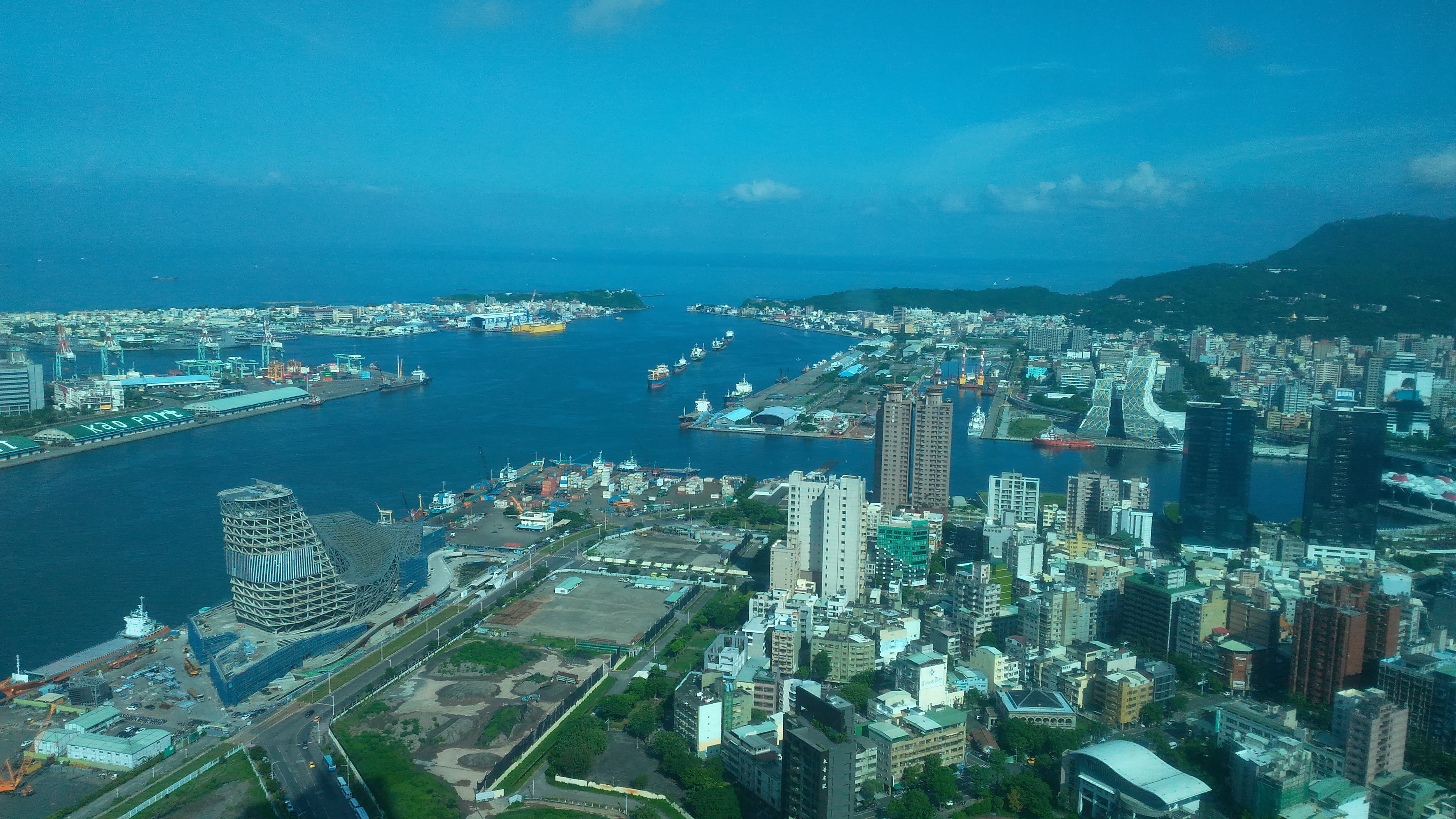
Aerial of Kaohsiung First Port and Container Terminal, photographed by Padai, CC BY-SA 4.0; aerial views can help understand the scale of harbor basins, yards, and the city, but do not represent the port area boundaries of all eras.

Railway Signal at Kaohsiung Port Station, Decommissioned, photographed by SSR2000, CC BY-SA 3.0; signals are objects of "allowing passage" in the port railway system, and also visible relics of the port's institutionalized transport.
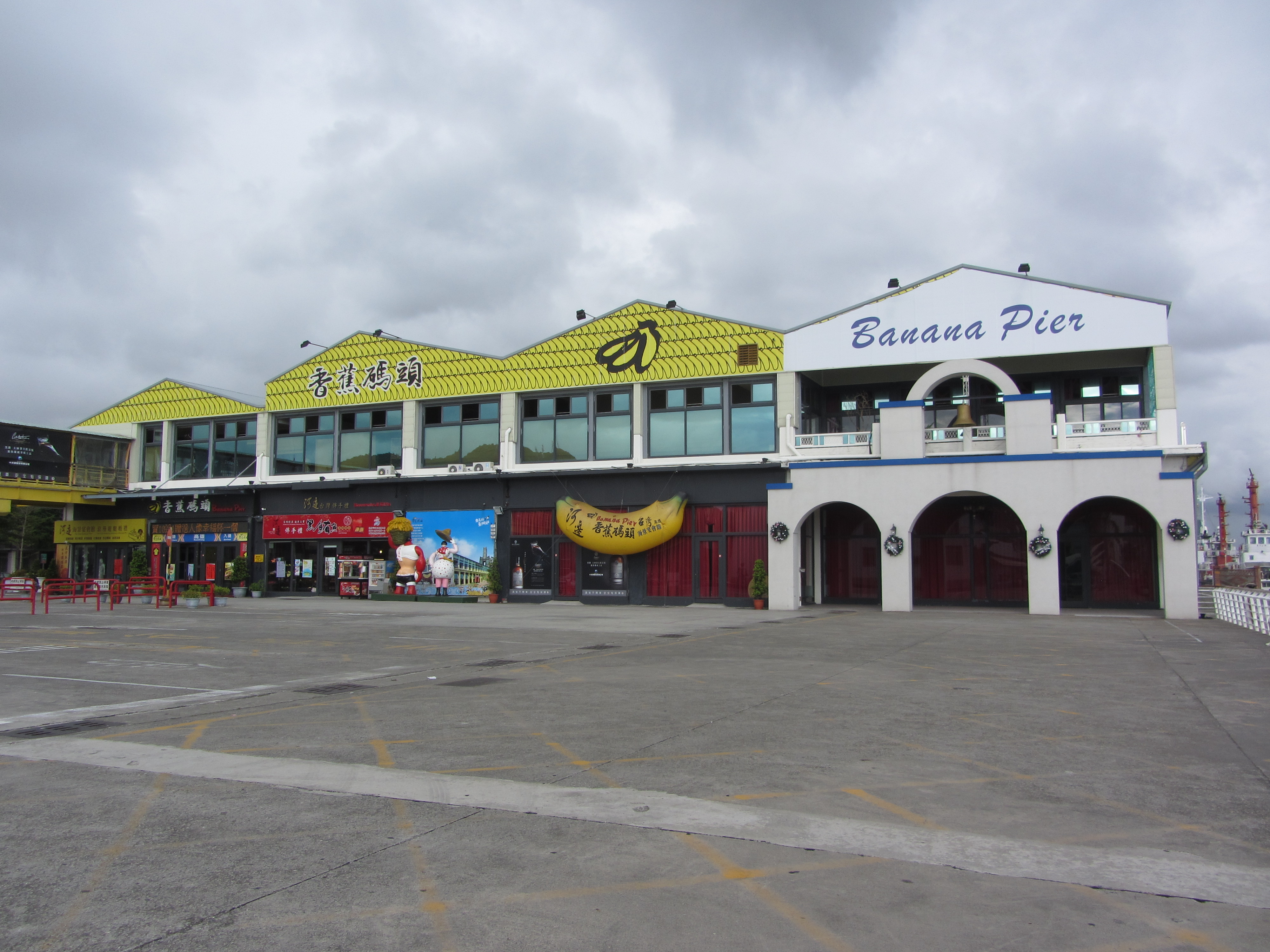
Kaohsiung Banana Pier, photographed by SSR2000, CC BY-SA 3.0; the photo presents the today's landscape and cannot be directly treated as historical images from the banana export peak period.
These six images are placed at the end of the article not to add a "check-in" filter to history, but to let readers see three different scales: the harbor is the scale of exchange between the city and the ocean, the banana shed is the scale of preserving and transferring agricultural products, and the port station railway is the scale of sending goods and people to the docks. If one only looks at today's skyscrapers and cruise ships, the port easily becomes scenery. If these landscapes are placed together with the previous text's taxes, packaging, port-side lines, and labor, one will know that the space of Kaohsiung Port is actually supported by many invisible rules. The added aerial views, signals, and banana pier images also deliberately correspond to three ways of reading the port: viewing scale from above, viewing systems from the ground, and viewing industrial memory from the old pier.
References
Image Sources and Licenses: All images in this article are external embeds from Wikimedia Commons and are not downloaded to the repository. Kaohsiung Port Scenery is photographed by Asacyan, CC BY-SA 4.0 (File Page); Kaohsiung Port Banana Shed is photographed by Pbdragonwang, CC BY-SA 3.0 (File Page); Kaohsiung Port Station Railway is photographed by Anav Rin, CC BY 2.0 (File Page); First Port and Container Terminal Aerial is photographed by Padai, CC BY-SA 4.0 (File Page); Port Station Decommissioned Signal is photographed by SSR2000, CC BY-SA 3.0 (File Page); Banana Pier is photographed by SSR2000, CC BY-SA 3.0 (File Page).
Further Reading
- National Cultural Heritage Network: Kaohsiung Port History Museum
- National Cultural Heritage Network: Banana Shed
- Archives and Technology Development Council: Banana Exports to Japan and the Taiwanese Economy
- Archives and Technology Development Council, Taiwan Setting Sail: A Century of Progress in the North and South Dual Ports — Explains the historical context of Dagou Port evolving from a fishing harbor to a north-south dual port and modern harbor construction.↩234567
- Dagou Kaohsiung | History and Present, The Story of Kaohsiung Port — Supplements local history data on the early landscape of Dagou Port, Hamaxing, and port-city development.↩234
- Kaohsiung Cultural Assets Network, Kaohsiung Port History Museum — Verifies the listing, architectural features, and local cultural asset positioning of the Port History Museum.↩234
- National Cultural Heritage Network, Kaohsiung Port History Museum — Provides national cultural asset records for the designation and architectural case of the Port History Museum.↩234
- Elsevier, Port-city interaction in Kaohsiung: A historical perspective — Provides academic research abstracts on the interaction between Kaohsiung Port and the city, and changes in port-city space.↩23
- Li Wen-huan, Yang Ching-hui, A Study on the Historical Changes of the Kaohsiung Port History Museum, Journal of Kaohsiung Normal University: Humanities and Arts, Issue 38 — Analyzes the architectural evolution of the Port History Museum, changes in port agencies, and the significance of preservation.↩23
- Taiwan Gazette, A new city on an old port: The 100-year transformation of Kaohsiung’s Love River — Explains the urban background of the 100-year transformation of the Kaohsiung port area from the perspective of the Love River and old port-city streets.↩234
- National Cultural Heritage Network, Banana Shed — Provides cultural asset case data and architectural preservation background for the Banana Shed.↩234
- Archives and Technology Development Council, Banana Exports to Japan and the Taiwanese Economy — Explains historical data on banana exports to Japan, industrial export, and the transshipment role of Kaohsiung Port.↩23
- Taiwan Ports Corporation Kaohsiung Port Branch, History of Port of Kaohsiung — Verifies official port history evolution, harbor construction projects, and the modernization stages of Kaohsiung Port.↩23
- Kaohsiung City Government Department of Urban Development, Asia Bay Upgrades Again! Banana Pier Welcomes AI Research Team — Explains the official planning of the Banana Pier in contemporary city reuse and industrial transformation.↩2