
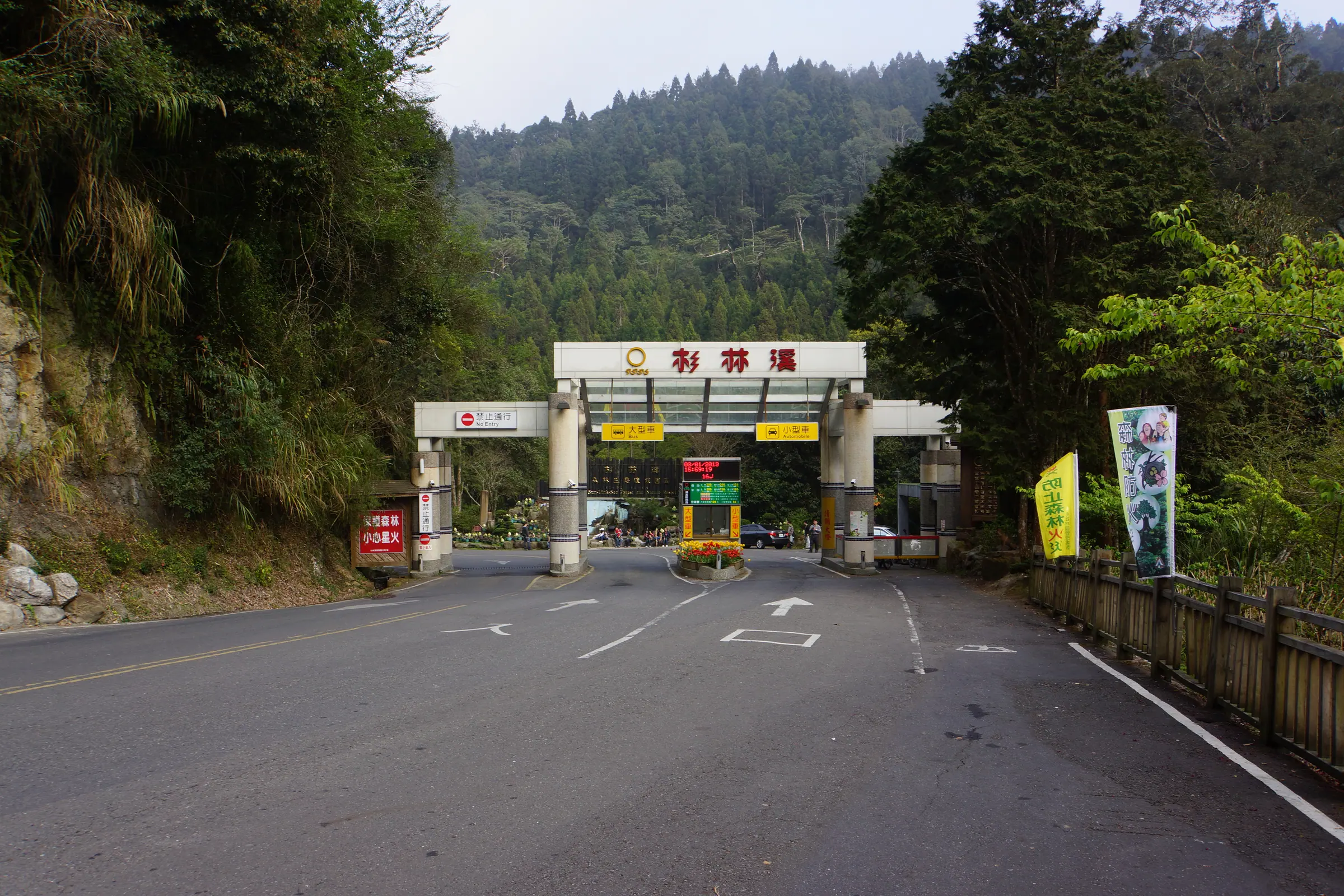
Shanlinxi Forest Ecology Resort, photographed March 1, 2013; lienyuan lee / Wikimedia Commons, CC BY 3.0. Image uses a remote hotlink; not downloaded or hosted.
30-Second Overview
Shanlinxi is located at No. 6, Xishan Road, Da'an Village, Zhushan Township, Nantou County. Environmental education certification data indicates the resort's elevation ranges from approximately 1,600 to 1,800 meters, unfolding along both banks of the Jiaziuliao Creek. It is most easily remembered for the Songlongyan Waterfall, but a more pressing question is: why did a valley originally sustained by logging, after road construction, tourism operations, typhoons, and the September 21 earthquake, return the forest, ecology, and environmental education to the center stage? 1 2 3
| Three Numbers Readers Remember First | Data |
|---|---|
| Location | No. 6, Xishan Road, Da'an Village, Zhushan Township, Nantou County; Coordinates 23.639794°N, 120.792255°E 1 |
| Valley Elevation | Approximately 1,600–1,800 meters above sea level; part of Taiwan's montane cloud forest zone 1 |
| Resort Scale | Along both banks of Jiaziuliao Creek, total leased area is approximately 34 hectares 1 |
Moisture Arrives First; Only Then Does Shanlinxi Speak
Entering the mountainous area from Zhushan, Nantou, the scale of the city gradually recedes behind the roads. The Shanlinxi Forest Ecology Resort is located in Da'an Village, Zhushan Township, extending along both banks of Jiaziuliao Creek. Official data describes this area as Taiwan's mid-elevation cloud forest zone. Mist, streams, slopes, and forests are not four separate attractions, but conditions interlinked within the same valley. 1 2
The current forest composition also preserves traces left by humans and the forest together. Environmental education certification data records that the original forest was a mixed coniferous and broadleaf forest, featuring Formosan red cypress and Chamaecyparis formosensis. The current main forest composition is a pure stand of Japanese cedar (Sugi) resulting from human-assisted regeneration, along with pure stands of Phyllostachys edulis (Moso bamboo) and Rhododendron reticulatum (Taiwan rhododendron). Viewing Shanlinxi merely as a "natural cedar forest" without history causes one to miss the most important issue here: how the forest was used, and how it was re-understood after use. 1
📝 Curator's Note
Shanlinxi's nature is not a landscape photo without fingerprints. The Sugi, logging roads, stream revetments, and the Environmental Education Center all tell us: humans have not stood outside the forest observing; humans have always left choices within the forest.
The Name "Xidi" Still Holds the Memory of Porters
The Shanlinxi official humanities and historical sites page states: "Shanlinxi was originally named Xidi." (Source: Shanlinxi Forest Ecology Resort official humanities and historical sites page) In early times, pioneers walked approximately five to six hours from Xitou to Xidi, with the route paved using stones or wood. Later, to transport forest products, horse paths, crude plank roads, and half-bridges appeared in the mountains. Humans or water buffalo pulled wooden sleds, transporting timber to the "stream cage head" (log sorting area), where it was transferred via cable to Xitou. 4
The weight of this history lies not just in the four words "once logged." It points to a very specific type of mountain labor: carrying heavy loads, climbing steep slopes, and relying on uneven paths to bring forest products out. When today's tourists walk on gentle trails, the sense of security underfoot actually contrasts with the timber transport roads of the past. 4
Official chronicles record that after the end of Japanese rule in Taiwan, precious timber gradually decreased, and logging ceased in the 52nd year of the Republic of China (1963). In the 58th year of the Republic of China (1969), the Xitou-Alishan longitudinal route was discovered, and mountain paths gradually became routes for hikers crossing the mountainous area. The same mountain domain successively bore different uses: timber extraction, transport, hiking, and tourism. 4
From Logging Camp to the Road Visitors Arrive On
In the 62nd year of the Republic of China (1973), Liu Anding and others organized Shanlinxi Leisure Business Co., Ltd. In the 64th year of the Republic of China (1975), the resort was permitted to lease land from the National Taiwan University Experimental Forest and build the connecting road from Xitou to Shanlinxi. The resort's chronicle views this engineering project as a precedent for private road construction. In the 68th year of the Republic of China (1979), construction began on the Xitou-Alishan Highway project, and the approximately 17-kilometer road from Xitou to Shanlinxi was completed in the 69th year of the Republic of China (1980). 4
In February of the 68th year of the Republic of China (1979), the resort's chronicle records the first guest staying at Shanlinxi. On March 29, 1980 (69th year of the ROC), the first tour bus entered the resort. These dates should be understood as records in the resort's publicly available historical chronicle, clearly marked as such when cited, rather than expanding corporate self-narratives into an uncontested full picture. 4
- 1963 (ROC 52): Official chronicles record the cessation of logging. 4
- 1969 (ROC 58): The Xitou-Alishan longitudinal route was discovered; mountain paths began to bear hiking functions. 4
- 1973 (ROC 62): Shanlinxi Leisure Business Co., Ltd. was organized. 4
- 1980 (ROC 69): The road from Xitou to Shanlinxi was completed; the resort records the entry of the first tour bus. 4
- 1999 (ROC 88): The September 21 earthquake caused the only connecting road to be cut off; the resort closed. 1 4
- 2003 (ROC 92): Anding Tunnel opened for traffic; the resort's chronicle records the resort reopening on September 1 of that year. 4
- 2010–2012 (ROC 99–101): The resort changed its name, established the Environmental Education Center, and obtained certification as an Environmental Education Facility. 1 4
Disasters Did Not Return the Valley to the Starting Point
Shanlinxi's turning point was not a smooth brand upgrade, but a start from cut-off roads. Environmental education certification data records that the 1999 September 21 earthquake caused the connecting road to be cut off, followed by impacts from Typhoons Herb and Toraji. The resort closed in 1999 and did not reopen until 2003. The resort's historical chronicle, however, records that in 2001 (ROC 90), emergency detours were cleared, and in 2003 (ROC 92), the Anding Tunnel opened for traffic. The reconstruction period was not a blank void where nothing happened. 1 4
The resort's chronicle further records that in 1996 (ROC 85), Typhoon Herb caused rainfall of over 2,000 millimeters in a single day, with flash floods impacting vehicles, boats, and connecting roads. This is a narrative from the resort's public chronicle; this article does not extend it into a rainfall record for the entire Nantou region. Within Shanlinxi's story, it primarily illustrates how roads, slopes, and hydrological risks directly determine whether a mountain amusement park can operate. 4
After reopening, following recommendations from the Forestry Bureau and the Special Research Center of Biodiversity, Council of Agriculture, the resort abandoned the mechanical amusement facility orientation and shifted to an ecological and natural route. This decision made "nature" no longer just the background of facilities, but the main subject that the resort must manage, explain, and continuously maintain. 1
In 2010 (ROC 99), the resort's name was changed from "Shanlinxi Forest Recreation Area" to "Shanlinxi Forest Ecology Resort." The Environmental Education Center was established in 2011 (ROC 100). In 2012 (ROC 101), it obtained certification as an Environmental Education Facility. The change in name and the establishment of educational institutions mark a redefinition of the resort's role. 4
Songlongyan Water's First Lesson: Seeing Drought
Songlongyan Waterfall is approximately 3.0 kilometers from the main building. Official data indicates a drop of over 38 meters, earning it the title "Shanlinxi's First Scenery." The natural cave next to the waterfall is called Songlongyan, primarily composed of sandstone. Official data links the cave's morphology to thermal expansion and contraction, weathering erosion, and differential erosion. 5
The Water Resources Bureau's E-Newsletter further explains that waterfalls, caves, riverbeds, and boulders are the results of long-term headward erosion, cutting, and infiltration by stream water. Humans standing before the cave see an attraction; the rocks record a time slower and longer than human lifespans. 6
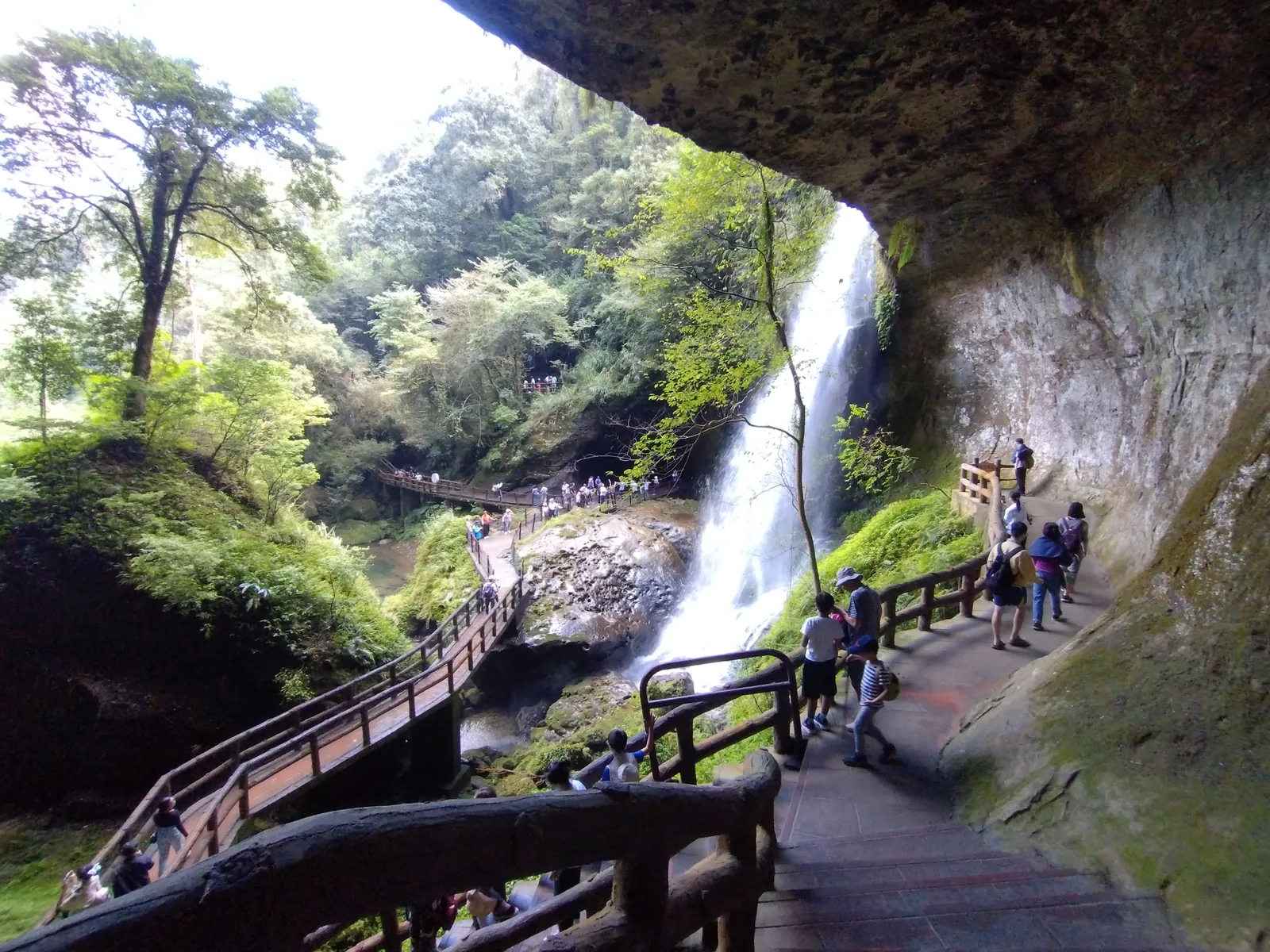
Songlongyan Waterfall, Shanlinxi, photographed September 30, 2023; Ephemeral Days / Wikimedia Commons, CC BY-SA 4.0.
In May 2023, the Nantou Tourism Network reported that Songlongyan Waterfall's flow shrank during the drought period, recovering after the plum rains replenished the upstream forest. The report quoted the resort using the term "peeing child" to describe the thin stream during drought, and "flying dragon in the sky" to describe the water flow after rain. These on-site terms transformed the waterfall from a fixed scenic spot back into a stream with hydrological changes. 7
The same report recorded that during the drought, negative ion measurements near the waterfall were approximately 2,000 per cubic centimeter, rising to 198,000 after the plum rains. The resort's attraction data describes normal levels as 20,000 to 50,000 per cubic centimeter, and approximately 190,000 during the rainy season. These are measurements from specific locations and times or resort explanations; they cannot be treated as fixed standards for every visit, nor can medical efficacy be derived from them. 5 7
✦ "Shanlinxi's First Scenery" is not a guarantee that the waterfall is always majestic, but a reminder: you must first ask which part of the mountain the water has traversed today.
Disaster Prevention Engineering Also Learns How to Retain Streams
Below Songlongyan Waterfall, there was once a deep pool with a history of flood overflow. Resort data indicates that existing revetments and bedrock stabilization structures also faced weathering issues. In 2021 (ROC 110), related engineering projects expanded the spillway cross-section of the water-retaining dam and used GRC (Glass Fiber Reinforced Concrete) imitation-rock methods to improve structure. The engineering simultaneously created fish passages, deep pools, shallow rapids, and turbulent flows, and installed longitudinal and lateral animal passages. 5
The significance of this engineering lies not in claiming "nature is fixed after engineering is completed," but in bringing together several problems usually treated separately: visitor safety, flood passage, aquatic habitats, and animal movement. Whether it is effective subsequently must still be tested by maintenance, rainfall events, and ecological monitoring. What can be confirmed is that the design goals described in the resort's data are no longer just a structure that blocks water. 5
Qinglong Waterfall, Shijingji, and Different Speeds of Water
Qinglong Waterfall drops from a series of cliffs 116 meters high. Both the Water Resources Bureau's E-Newsletter and the resort's official data describe that it may present a thin stream during the dry autumn and winter seasons, but its momentum increases due to increased water volume after heavy rain. On clear days, water mist and sunlight may also form rainbows, but this is affected by weather and observation position, and does not appear on every visit. 8 6
Shijingji is not a water scene falling from a height, but a stream carrying sand and gravel, rotating and eroding on rock layers of different hardness, forming circular depression pothole landforms. Resort data states there are over ten Shijingji in the local area, with some depths reaching 5.5 meters. These values come from the resort's attraction introduction; when near the water, one must still follow on-site regulations and should not treat landscape descriptions as permits for wading, swimming, or climbing. 8 9
Longlin Waterfall places seasonality even more prominently. Resort data indicates that during the drier autumn and winter, one might only see dry rock walls, while in the spring and summer rainy seasons, water flow can be seen falling along the rock walls. Shanlinxi's waterfall group is therefore not a copy of the same "majestic" image: Songlongyan lets people see the rock cave and water curtain, Qinglong Waterfall lets people see the drop and mountain mist, Shijingji lets people see how the stream erodes the rock bed, and Longlin Waterfall lets people see seasonal differences in water volume. 8
One Trail, Connecting Timber Transport, Streams, and Giant Trees
The official tour route page divides itineraries into half-day tours, one-day tours, and overnight two-day tours. The half-day hiking route starts from the Service Center, passes the Environmental Education Center, the Ridge Ancient Trail, Qinglong Waterfall, the Ba Ba Suspension Bridge, Shijingji, and Fude Temple, returning to the Service Center. Official reference times are approximately 40 minutes for the Ridge Ancient Trail and 15 minutes for the Shijingji Trail, but actual times vary with stops, weather, and road conditions. 10
One-day Hiking Route A moves from the Service Center towards Qinglong Waterfall and Shijingji, with the official full journey time marked as approximately 2 hours. Route B passes the Forest Crossing Plank Road, Flower Center, Leshan Trail, Songlongyan, Tianyan Trail, Pioneer Tunnel, Millennium Red Cypress, and Tiandiyan, with the official full journey time marked as approximately 4 hours. The former places streams, waterfalls, and potholes on the same stretch of road; the latter connects flowers, waterfalls, logging relics, and giant trees. 10
The Forest Crossing Plank Road is approximately 1,800 meters long, with an official walking time of approximately 40 minutes; it was formerly a logging transport plank road. The Tianyan Trail is approximately 900 meters long, with an official walking time of approximately 25 minutes; along the way, one can pass the Pioneer Tunnel, Millennium Red Cypress, and Tiandiyan. The Leshan Trail is approximately 1,200 meters long, with an official walking time of approximately 20 minutes, connecting the Flower Center and Songlongyan Waterfall. These numbers are not just itinerary tools; they allow people to see different layers of mountain forest use. 8 10
Under the Taiwan Rhododendron Forest, Seasons Become Habitat Observation
Taiwan Rhododendron Forest Trail; image from Shanlinxi Forest Ecology Resort official attraction page. This image is an official remote hotlink.
The Taiwan Rhododendron Forest Trail is approximately 1,700 meters long. Official data indicates an elevation of approximately 1,691 to 1,802 meters, a vertical drop of 103 meters, and a walking time of approximately 60 minutes. The trail includes log sections and natural dirt sections covered with fallen leaves. The route loops into a circle; after reaching the fork, one can return to the starting point via the left or right side. 9
The resort introduces that there are Taiwan rhododendrons on both sides of the trail, with approximately 1,500 plants in the resort, reaching heights of up to 8 meters. There are approximately 120 plant species along the way, with Monotropa uniflora (Indian pipe) as a representative plant. These numbers are descriptions from the resort's official attraction page; this article does not extend them into population estimates for all of Taiwan. 9
The Environmental Education Center's activity page places Monotropa uniflora and the Taiwan rhododendron in a habitat context, stating that visiting under the rhododendron forest from March to May may allow observation of the chlorophyll-free Monotropa uniflora, introducing its survival environment and conservation methods through interpretive activities. The most important action here is not to find more, but to stay on the trail, not step on or pick plants, and not extend one's body into the vegetation for photos. 11
The Flower Center belongs to another way of viewing. The resort's official attraction data lists representative flowers such as peonies, cabbage roses, hydrangeas, tulips, golden bells, and mountain cherries. The artificial display space and the habitat observation under the rhododendron forest are both worth seeing, but they cannot be understood by the same set of standards. 8
From Timber to Environmental Education
Shanlinxi Environmental Education Center's courses include outdoor activities, professional teaching, and regional tours. The Exhibition Center introduces the resort's landscape, trails, and mid-to-high altitude flora and fauna resources, along with an ecological library and outdoor activity fields. Course themes cover ferns, fireflies, butterflies, astronomy, birds, water quality, and forests. 11
The Wood Culture Activities transform the resort's logging history into experiential courses, including sawing wood, splitting timber, dragging sleds, tree measurement, and discussions on carbon sequestration. The value of this design is that conservation does not pretend the forest was never used by humans, but allows participants to understand the methods of use, costs, and subsequent responsibilities. 11
Environmental education certification data records that Shanlinxi Environmental Education Center obtained certification as a private enterprise environmental education center in 2011, with the current certificate valid until August 26, 2027. The resort's Environmental Education Center writes its direction as "Exploring Shanlinxi's Ecological Mysteries." (Source: Shanlinxi Environmental Education Center official website) 1 11
The Water Resources Bureau's E-Newsletter also records that Shanlinxi has volunteers and lecturers leading environmental education activities, covering Songlongyan Waterfall, the Golden Water Cedar Forest, the Botanical Garden, and the Qinglong Fern Trail. The value of the tour lies not only in adding attraction names, but in pushing "what was seen" to "why it is here." 6
📝 Curator's Note
Shanlinxi makes environmental education a continuous action on a trail: first look at a flower, then ask about its habitat; first touch a piece of wood, then ask who the forest once worked for.
Before Entering the Valley, Check the Day's Rules Clearly
The current official tour route page still lists the itinerary for the tour electric bus, but the same page has another announcement stating that, starting March 9, 2026, the tour shuttle will suspend operations. The resort's homepage also reminds visitors to slow down and stroll in the resort. Therefore, one cannot rely solely on the old route page to arrange shuttles; one should reconfirm the day's service status before departure. 3 10
As of August 15, 2026, the official website also announced that, starting September 1, 2026, Highway Bus 6277 "Xitou—Shanlinxi" will cease operations, and提示 alternative routes 6883B and 6883C. This is traffic information with date validity and cannot be viewed as a permanent rule. If transferring from Xitou or Taichung, one must re-query before departure. 3
The resort's official website announces the prohibition of remote-controlled drones or aerial photography flights. The Taiwan Rhododendron Forest Trail data reminds that some sections are log steps, unsuitable for wheelchairs and strollers. The resort also prohibits open flames, barbecues, cooking, swimming, fishing, and setting off fireworks, and requires visitors not to steal, destroy, carve, pollute, or hunt. 3 9
Two Ways to View Shanlinxi
| If You Want to See | Suggested Focus | Limitations to Acknowledge |
|---|---|---|
| Waterfalls and Topography | Songlongyan, Qinglong Waterfall, Shijingji; observing differences in water curtains, drops, and potholes 5 8 | Rainfall changes water flow; water areas are not swimming pools, and wading is not permitted 8 9 |
| Forest and Seasons | Taiwan Rhododendron Forest Trail, Flower Center, Environmental Education activities 8 9 11 | Flower periods and biological appearance times are affected by seasons; one cannot leave the trail for photography 9 11 |
After the Sound of Water Departs, What Does the Forest Leave Behind?
Shanlinxi's story begins with the "Xidi" logging camp, passes through road construction, tourism operations, Typhoon Herb, the September 21 earthquake, and connecting road reconstruction, finally moving towards environmental education. This route does not erase the past: the resort's current Japanese cedar forest is a forest composition left by artificial regeneration. Environmental education activities also bring logging culture back into courses, letting visitors know that a forest's today often includes yesterday's human choices. 1 4 11
Songlongyan Waterfall can become thin during droughts and recover its flow after the plum rains. Qinglong Waterfall may only have a thin stream in the dry season, turning into a rapid water curtain after heavy rain. Shijingji hides the power of water flow in the concave depressions of the rock bed. The Taiwan rhododendron and Monotropa uniflora hide seasons under the forest canopy. Shanlinxi is not a fixed postcard, but a set of mountain forest relationships that change with rainfall, seasons, engineering, and human behavior. 5 7 8 9
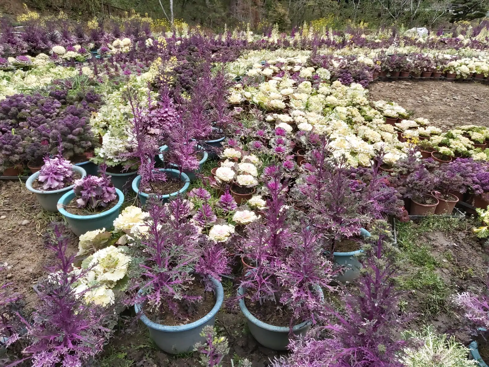
Shanlinxi Forest Ecology Resort Flower Center, photographed March 13, 2024; Adao / Wikimedia Commons, CC BY-SA 4.0.
You can leave photos for Shanlinxi, or just leave a few slower actions: listen to the sound of water for a while before Songlongyan, do not step on a small plant under the rhododendron forest, watch how the stream erodes a cave beside Shijingji. When you begin to notice changes in the sound of water, Shanlinxi is no longer just a spot you have arrived at, but a valley that will continue to change.
Image Sources
All images in this article use remote image URLs and are not downloaded or re-hosted. Captions retain only author and licensing information. Source pages are listed centrally in this section to avoid placing links with percent-encoded Chinese filenames in italic captions.
Image 1: Shanlinxi Forest and Valley Landscape, lienyuan lee, CC BY 3.0. 12
Image 2: Songlongyan Waterfall, Ephemeral Days, CC BY-SA 4.0. 13
Image 3: Taiwan Rhododendron Forest Trail, Shanlinxi Forest Ecology Resort official attraction page. 9
Image 4: Shanlinxi Flower Center, Adao, CC BY-SA 4.0. 14
References
- Environmental Education Certification System: Shanlinxi Forest Ecology Resort — Address, coordinates, elevation, forest composition, logging camp history, earthquake reconstruction, and environmental education certification data.↩23456789101112
- Nantou Tourism Network: Shanlinxi Forest Ecology Resort — Administrative district, resort features, trails, and public transport information.↩2
- Shanlinxi Forest Ecology Resort Official Website — Resort announcements, traffic changes, tour bus and drone regulations; verification date 2026-08-15.↩234
- Shanlinxi Forest Ecology Resort: Humanities and Historical Sites — Original name Xidi, logging period, road construction, tourism operations, earthquake reconstruction, and transformation chronicle.↩2345678910111213141516
- Shanlinxi Forest Ecology Resort: Songlongyan Waterfall — Waterfall drop, sandstone cave, erosion landforms, negative ions, and disaster prevention ecological engineering.↩23456
- Ministry of Economic Affairs Water Resources Bureau E-Newsletter: Environmental Education Field - Shanlinxi Forest Ecology Resort — Songlongyan, Qinglong Waterfall, environmental education tours, and geological descriptions.↩23
- Nantou Tourism Network: "Shanlinxi's First Scenery" Reappears with Flying Dragon's Majestic Flow — 2023 drought, plum rains, water flow, and on-site measurement data.↩23
- Shanlinxi Forest Ecology Resort: Surrounding Attractions — Qinglong Waterfall, Shijingji, Longlin Waterfall, trails, Millennium Red Cypress, and Flower Center data.↩23456789
- Shanlinxi Forest Ecology Resort: Taiwan Rhododendron Forest Trail — Trail length, elevation, rhododendron forest, Monotropa uniflora, trail difficulty, and conservation regulations.↩23456789
- Shanlinxi Forest Ecology Resort: Tour Routes — Half-day, one-day, two-day routes and official reference walking times; same page contains shuttle bus change announcements.↩234
- Shanlinxi Environmental Education Center: Thematic Education and Center Introduction — Monotropa uniflora, Taiwan rhododendron, fireflies, birds, water quality, wood culture, and environmental education courses.↩234567
- Wikimedia Commons: Shanlinxi Sun-Link-Sea Forest and Nature Resort - panoramio.jpg — lienyuan lee, March 1, 2013, CC BY 3.0.↩
- Wikimedia Commons: Sun link Sea 6.jpg — Ephemeral Days, Songlongyan Waterfall, September 30, 2023, CC BY-SA 4.0.↩
- Wikimedia Commons: Sun Link Sea-37.2024-03-13.jpg — Adao, Flower Center, March 13, 2024, CC BY-SA 4.0.↩


