30-second overview: Spread out a map of Taiwan, and most people see a small island on the edge of the Chinese mainland. But rotate the map clockwise by 30 degrees, then extend your view southward, and you will see another map that is just as valid: Taiwan is also the northeastern edge of the Malay world (Nusantara), the linguistic homeland of 400 million Austronesian speakers, and the starting point of Pacific dispersal history. A jade slit-ring earring made from stone quarried in Fengtian, Hualien had already appeared 3,500 years ago in archaeological sites in Batanes, Luzon, Vietnam, and Thailand. Linguist Robert Blust inferred from lexical diversity that nine of the ten primary branches of Austronesian are in Taiwan. The language spoken by the Tao people of Orchid Island shares about 60% intelligibility with Ivatan in Batanes. What this article aims to do is restore another overlooked map, so that Taiwan can be seen more truthfully through both maps together.
Open Google Maps and rotate Taiwan 30 degrees southward. Let the Bashi Channel face downward, let the ridge of the Central Mountain Range point toward the northern tip of Luzon, and let Taroko in Hualien line up with the Batanes Islands of the Philippines.
What you see then is not a small island beside the eastern rim of the Chinese mainland, but the northernmost node in a chain of islands. To the south: Orchid Island, Batanes, Luzon, Palawan, Borneo, Java, Sumatra, extending all the way to Madagascar. To the east: the Ryukyus, Kyushu, and the Kuril Islands. To the southeast: Micronesia and Polynesia, reaching as far as Easter Island. From this orientation, Taiwan is one endpoint of an island world spanning half the globe, not the periphery of any continent.
3,500 years ago, a piece of Taiwanese nephrite quarried in Fengtian, Hualien was cut and polished by artisans of the Beinan culture into a slit-ring earring. It moved south along branches of the Kuroshio Current, eventually reaching a settlement at the northern tip of Luzon, and finally appeared in a site that 21st-century archaeologists would name “Nagsabaran”1. The same jade material has been excavated from prehistoric burials in Vietnam, Thailand, and the Malay Peninsula. After isotope analysis, archaeologists determined that these jade materials came from the same vein: Fengtian, Hualien.
In other words: 2,000 years before the Chinese framework reached this island, the island was already a center of a trade network spanning the South China Sea.
This is not to deny Taiwan’s Chinese roots. Since Qing rule began in 1683, Han migration has shaped language, lineage, belief, and foodways, and these are indeed the thickest layer of contemporary life on this island. But beneath that layer are several earlier ones. Another map long obscured by the Chinese framework, the Nusantara map, the archipelago map, is what this article attempts to restore.
The Journey of a Jade Artifact: From Hualien to Luzon
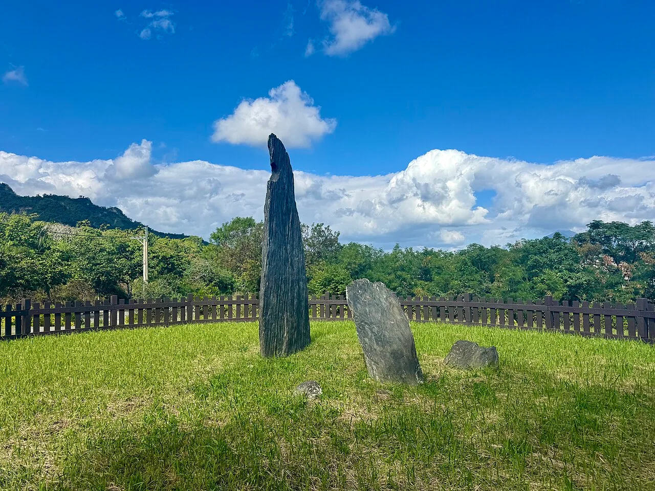
In 1980, in Beinan Township, Taitung. While building the new Taitung Station for the South-Link Railway, construction workers unearthed stone slabs and pottery shards. The rescue archaeology that followed revealed a prehistoric settlement spanning three millennia, from 5,300 to 2,300 years before present: the Beinan Site2.
Archaeologists recovered more than 5,000 jade artifacts from the Beinan Site, in nearly 20 types: human-animal-shaped jade slit-ring earrings (two side-by-side human figures topped by an animal, an iconic image of Taiwan’s prehistoric art), double-animal earrings, jade tube beads, bell-shaped jade beads, jade rings, jade adzes, and jade arrowheads. Official materials from the Ministry of Culture describe this settlement as a core node in the “maritime trade of Taiwan jade”3.
These jade artifacts were not locally produced. The raw jade came from Fengtian, Hualien: a nephrite belt on the eastern edge of the Central Mountain Range, south of the Liwu River, about 150 kilometers north of the Beinan Site. At the Cigan Site in Hualien, archaeologists excavated clusters of specialized jade workshops: artisans used quartz-mica schist as saw blades, bamboo tubes as drill bits, and quartz sand as abrasive, cutting earring blanks from rough jade before transporting them to settlements such as Beinan, Shisanhang, and Yuanshan for fine processing4.
But this is only the beginning of the story.
💡 Did you know
In the 1970s, Fengtian jade once accounted for 90% of the global jade market, with annual exports in 1976 reaching NT$5 billion. What most people do not know is that this mineral vein had already become an international trade commodity 4,000 years ago. Long before “Made in Taiwan” became a trademark, Taiwan jade had circulated in the trade networks of the South China Sea and western Pacific for three millennia.
Between 4,000 and 2,500 years ago, Beinan-style jade slit-ring earrings appeared successively in archaeological sites on Luzon, Palawan, and Batanes in the Philippines, as well as farther south in Vietnam, Cambodia, and Thailand. The Batanes Archaeological Project, conducted from 2002 to 2005 by the Australian National University, the National Museum of the Philippines, and the University of the Philippines, confirmed that the earliest Neolithic migrants in Batanes came from Taiwan, and that Taiwanese materials such as jade and slate continued to circulate through Green Island and Orchid Island as intermediaries until about 1,300 years ago5.
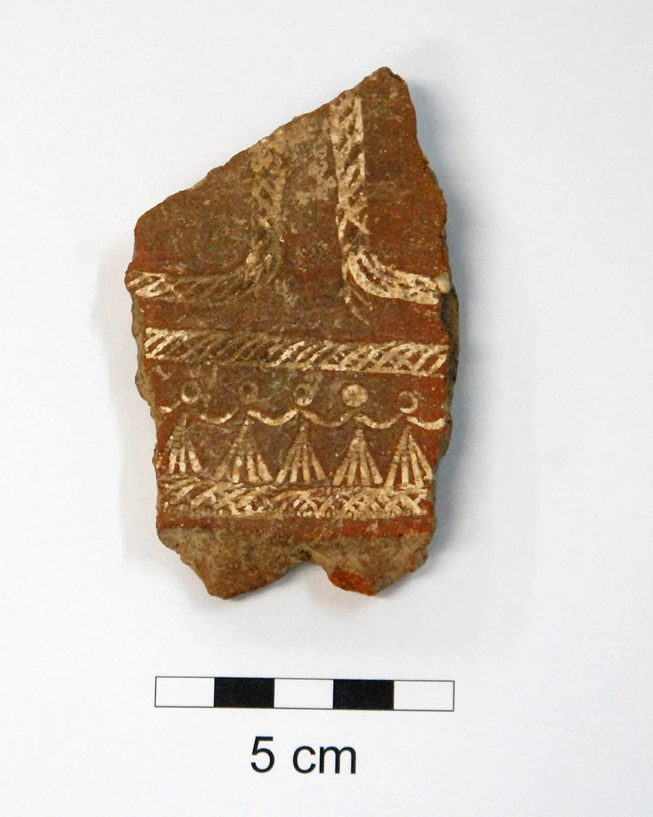
The movement of objects was not one-directional. This was a dense, two-way woven network. Red pottery excavated by archaeologists at the Nagsabaran Site in northern Luzon is almost of the same technological lineage as the cord-marked red pottery of Taiwan’s Dapenkeng culture6. Farther south, “Lapita culture” pottery excavated in Micronesia and western Polynesia, marked with complex geometric patterns impressed by dentate tools, can be traced back to northern Luzon, whose roots in turn point to Taiwan7.
📝 Curator’s Note
If you spread the archaeological evidence out on a table, you will see a complete chain: Fengtian, Hualien → Beinan → Orchid Island → Batanes → Luzon → Borneo → the Bismarck Archipelago → Oceania. Objects do not lie. A piece of jade quarried from the mountains of Hualien 3,500 years ago now rests in a display case in the Fiji Museum. This is the most concrete evidence for “archipelago thinking.”
The Diversity Principle: Why Linguists See Taiwan as the Homeland
In 1984, University of Hawaiʻi linguist Robert Blust published an article that would shape the next four decades of scholarship: “The Austronesian Homeland: A Linguistic Perspective”8. He argued that the homeland of the Austronesian language family is Taiwan.
Blust’s argument rests on a methodology called the principle of linguistic diversity.
Put simply: the farther a language family spreads, the greater the lexical and grammatical diversity in its homeland. The reason is time. People in the homeland remain there and slowly differentiate into mutually unintelligible sister languages; migrants leave with the language of their time, then differentiate again in new places. Therefore, the homeland has the deepest roots of divergence, while the languages of migration zones are branches of only one part of the tree.
Apply this principle to Austronesian:
There are about 1,300 Austronesian languages on Earth, spoken by 400 million people, spanning 206 degrees of longitude geographically, from Madagascar to Easter Island. No other language family has covered such a distance. Blust reconstructed a genealogical tree for these 1,300 languages and found that nine of the ten primary branches of Austronesian are in Taiwan9.
The remaining branch is called Malayo-Polynesian, and it includes all Austronesian languages outside Taiwan: the Philippines, Indonesia, Malaysia, and the entire Pacific.
In other words: Tagalog in the Philippines, Malay in Indonesia, Hawaiian, Māori, Malagasy, and six or seven hundred other languages together occupy only one-tenth of the Austronesian family tree. The remaining nine-tenths of its diversity is compressed into the twenty-some Indigenous languages on the island of Taiwan.
✦ “The Austronesian expansion is one of the greatest chapters in human history. It spans half the globe, and after branching out from Taiwan, it left linguists today with the deepest genealogical tree.” (Attributed to Robert Blust, 2022 interview)
Blust is not the only scholar to make this argument. Archaeologist Peter Bellwood reached the same conclusion from the perspective of material culture10. In 2009, Russell Gray, Alexei Drummond, and Simon Greenhill of the University of Auckland published a paper in Science using Bayesian phylogenetic methods to analyze lexical data from 400 languages, calculating that Austronesian began dispersing from Taiwan about 5,230 years ago11. A team led by Chung Kuo-fang at Academia Sinica approached the question through plant DNA: by analyzing the DNA of paper mulberry, a key plant for making barkcloth, in East Asia and the South Pacific, they found that the haplotypes of paper mulberry in Oceania originated in southern Taiwan12.
Four independent paths, linguistic diversity, archaeological material culture, Bayesian phylogenetics, and plant DNA, point to the same conclusion.
⚠️ Contested Viewpoint
Not all scholars accept this conclusion. Martin Richards and others at the University of Cambridge have argued from archaeogenetics that post-Ice Age sea-level rise, around 8,000 years ago, may have caused population expansion in the Indonesian region and may have determined the genomic composition of Oceania earlier. Language dispersal may have been “cultural diffusion,” meaning local populations adopting an incoming language, rather than “population migration.”
This debate reflects the methodological limits of prehistory more than the collapse of the conclusion itself. Even if Richards’s revision is accepted, the linguistic conclusion that “Austronesian branched out from Taiwan” has not been shaken. The truly open question is whether people moved along with the languages.
Nusantara: A 14th-Century Word, A Map of the Archipelago
To understand “archipelago thinking,” one must first understand a word: Nusantara.
The word consists of two roots. Nusa comes from Old Javanese and means “island”; traced further back, it derives from Proto-Malayo-Polynesian *nusa, a word of Austronesian ancestors. That is to say, the cognate concept of “island” found in Taiwan’s Indigenous languages remains alive across Austronesian languages. Antara is a loanword from Sanskrit meaning “between” or “intermediary.” Together, Nusantara means “the islands between,” “the archipelago scattered between the inner and outer worlds”13.
The word first appeared in the 14th-century Javanese texts Pararaton and Nagarakretagama. In 1336, Gajah Mada, prime minister of the Majapahit Empire in East Java, delivered the famous Palapa Oath (Sumpah Palapa) at his inauguration: “I will not taste spice-laden food until I have conquered all of Nusantara”14.
At the time, Nusantara referred to the outer islands beyond Java: Sumatra, Borneo, Sulawesi, the Malay Peninsula, and even as far as Luzon. Contemporary Indonesia still uses the term to refer to the archipelago itself. In 2022, Indonesia announced the relocation of its capital, and the new capital was named Nusantara15.
But the way Nusantara is used in this article differs from the territorial imagination of Indonesian nationalism. What we borrow is the term’s cultural-geographical meaning before the modern nation-state: a world spanning the South China Sea and western Pacific, composed of more than 24,000 islands, where people, objects, languages, and beliefs moved more frequently between islands than between land and island.
Spread out this map, and Taiwan is not at the periphery. It is the northeastern edge.
Orchid Island as Living Evidence: Two Peoples with 60% Shared Intelligibility
If the journey of Hualien jade artifacts is “dead evidence,” meaning excavated material, then the story of Orchid Island is “living evidence.”
Orchid Island is home to the only one of Taiwan’s 16 Indigenous peoples that has preserved a complete maritime culture: the Tao people, formerly known as the Yami. They build plank boats, hold flying fish ceremonies, and construct semi-subterranean houses to withstand typhoons.
From the southernmost village of Imorod on Orchid Island, looking south, the Batanes Islands of the Philippines lie only 82 kilometers away. The people living there are called Ivatan.
The Tao language and Ivatan share about 60% lexical intelligibility16.
This is not merely “cultural similarity.” This is the level of two peoples who were originally one group and separated only a few hundred years ago. For comparison: Southern Min and Cantonese share roughly 40-50% lexical overlap; Tao and Ivatan are higher than that.
Tao oral history is clear: their ancestors once lived on Itbayat Island in Batanes, then migrated north to settle on Orchid Island several centuries ago. Archaeologists excavating prehistoric burials on Orchid Island have found jade artifacts, pottery jars, glass beads, and agate beads whose composition is almost identical to materials excavated from contemporaneous sites in Batanes17.
Since the 1990s, Tao people have repeatedly organized visits to Batanes to search for their roots. On Itbayat, they found relatives with whom they could communicate directly through language. They had been separated by several centuries, yet if they spoke slowly, both sides could understand each other. Shared ancestors, shared vocabulary, and shared seafaring technologies were never severed by the ocean18.
📝 Curator’s Note
Place the Tao search for roots inside the Chinese framework, and one might call it “cross-border exchange by Taiwan’s Indigenous peoples.” But place it inside the archipelago framework, and the story is entirely different: this is a family separated by a strait a thousand years ago visiting relatives again. The term “cross-border” itself is an invention of the 20th-century nation-state. For people moving back and forth across the Bashi Channel in plank boats 4,000 years ago, both the northern and southern ends were part of the same home.
Both Tao and Ivatan belong to the Malayo-Polynesian branch of Austronesian, and are more distant from the languages of the other 15 Indigenous peoples on Taiwan proper, which belong to the nine major “Formosan” branches. In other words, the Tao are closer to the Ivatan of Batanes than they are to the Amis19.
This is living evidence of the “archipelagic continuum.” Borders are political and geographic divisions, but language and blood do not recognize passports.
The Nusantara Archive: How Contemporary Art Completes the Map
Academic research and archaeological excavation have accumulated evidence for the “archipelago,” but for this map to enter the consciousness of contemporary Taiwanese people, papers are not enough. It must be continually written, exhibited, translated, and transmitted.
In 2016, Taiwanese art critic Cheng Wen-chi, founder of the online art publication No Man’s Land (NML), attended a symposium in Yogyakarta called “Revisiting Malaya 2.0.” The conference explored political and historical intellectual connections in the Malay world. After returning to Taiwan, he launched a multi-year project called the Nusantara Archive20.
The project’s core idea was “completing the map through curation.” NML invited artists from Malaysia, Singapore, Indonesia, and the Philippines to Taiwan for residencies, and also sent Taiwanese curators to Kuala Lumpur, Penang, and Yogyakarta. Residencies, translation, and co-production moved in both directions. Introducing the project, Cheng wrote:
“‘Nusantara,’ though a project formed from the medieval Java-centered terms ‘island’ (nusa) and ‘other’ (antara) ... when referring to a regional database that includes Taiwan, may be said to embody a ‘meta’ textual perspective like that of No Man’s Land.”21
Beginning in 2017, NML released a series of special issues: Issue 34, “Hermeneutics of Nusantara”; Issue 12, “Twinning the Wastelands”; Issue 21, “Recalling Islands”; and Issue 47, “Legible Singapore / Nusantara in Future Tense.” Invited artists included Malaysia’s Okui Lala, Hoo Fan Chon, Au Sow Yee, and Wensu Wong, as well as Singapore’s Ng Ting Kuan and Zikri Rahman of the street bookstore collective Buku Jalanan.
These artists’ works share a common methodology: tracking inter-island movement through concrete objects.
Okui Lala takes “Hokkien” as her point of entry. She asks: how did this language, likewise originating from Minnan, become Taiwanese in Taiwan, Fujianese speech in Malaysia, Hokkien in Indonesia, and Bahasa Hokkien in Singapore? Each branch has different grammar, loanwords, and tones, yet when speakers meet, they can still understand much of what the other says.
Hoo Fan Chon takes “tilapia” as his point of entry. This African cichlid was brought from Singapore to Taiwan in 1946 by two Taiwanese soldiers, and later became a mainstay of Taiwan’s aquaculture industry. He asks: when a fish crosses national borders, crosses war, changes species names, and becomes an entire industry, what is the identity of that fish?
💡 Did you know
Under the Nusantara framework of No Man’s Land, Taiwan is repositioned as the northeastern edge of the Malay world and the northwestern edge of the Pacific. From this perspective, its most natural neighbors are Penang, Kuala Lumpur, Jakarta, Manila, and Singapore. A Taiwanese editor named Cheng Wen-chi, together with people named Choy Chang Hong from Malaysia, Suzy Sulaiman from Penang, Syafiatudina from Yogyakarta, and Alecia Neo from Singapore, has spent more than a decade filling in this map.
In the editor’s note for NML Issue 34, Cheng quoted Indonesian scholar Khoo Gaik Cheng’s reflection on “comparison”:
“The process of relativizing the experiences of different places is not merely a matter of understanding as knowledge, but of truly connecting them with one’s own history.”22
He also quoted Benedict Anderson in A Life Beyond Boundaries:
“Comparison is not a method or even an academic technique; rather, it is a discursive strategy.”23
To treat the “archipelago” as a discursive strategy means: we do not have to decide in advance which grand framework Taiwan belongs to, whether Chinese, East Asian, Austronesian, Malay, or Pacific. We can move, compare, and align between each map, seeing another side of Taiwan from each one.
Seeing Three Maps Together: The True Meaning of SSODT
By this point, the core argument of this article has already taken shape: Taiwan can be marked by three maps at the same time, and all three are true.
The first: the Chinese framework. Qing rule in 1683, the Treaty of Shimonoseki in 1895, and the postwar rupture of 1949: this timeline shaped the thickest layer of Taiwan today. Southern Min, Hakka, Han lineages, temple beliefs, rice foodways, and calligraphy education are all expressions of this foundation. This map is not wrong.
The second: the Austronesian homeland. Starting 5,230 years ago, Taiwan became the endpoint with the greatest diversity in the world’s most widely dispersed language family. Blust’s diversity principle, Gray’s Bayesian analysis, and Chung Kuo-fang’s paper mulberry DNA each independently point to the same conclusion. The 60% lexical intelligibility between Orchid Island and Batanes is living evidence. This map is not wrong either.
The third: the northeastern edge of the Nusantara Malay world. Beinan jade artifacts had already appeared in archaeological sites in Luzon, Vietnam, and Thailand 3,500 years ago. Over the past decade, Cheng Wen-chi’s “Nusantara Archive” has brought this map into contemporary consciousness through curation. Rotate the map southward, and Taiwan is the northernmost endpoint of a world of 24,000 islands. This map is also not wrong.
The three maps are not mutually exclusive choices. They correspond to the truths of Taiwan at different time scales and different social levels. The first map is the story of the past 350 years. The second map is the story of the past 5,000 years. The third map is the horizontal scale of cultural exchange.
✦ The real question is not “where does Taiwan belong,” but “whether we are aware of the existence of all three maps at the same time.” For a long time, textbooks taught only the first map, mentioned the second vaguely, and omitted the third entirely. What this article aims to do is put the latter two maps back on the table together.
The Government’s “Austronesian Diplomacy”: A Limited but Real Beginning
Completing the map is not only a matter for academia or art. Taiwan’s diplomatic system is also using the concept of “Austronesian peoples” to build connections with Pacific island countries.
Since 1993, Taiwan has participated in the Pacific Islands Forum (PIF) as a “Development Partner,” maintaining regular dialogue with diplomatic allies such as Palau, the Marshall Islands, Tuvalu, and Nauru24. The International Conference on Austronesian Peoples, held every two years, is co-organized by the Council of Indigenous Peoples and the Ministry of Foreign Affairs; its 15th edition was held in 2017. In May 2025, the Ministry of Foreign Affairs submitted a special report to the Legislative Yuan listing “combining Austronesian-language countries to advance values-based diplomacy” as part of integrated diplomacy25.
⚠️ Contested Viewpoint
Using “Austronesian connections” as a diplomatic tool is not without problems. Critics point out that when the government commodifies the “Austronesian” framework as a diplomatic asset, it may instead squeeze the issue space of Indigenous peoples within Taiwan: they are the living carriers of the “homeland,” not instruments of diplomacy. Australia and New Zealand have followed a more mature path: first address domestic Indigenous rights, including land, language, and autonomy, so that external Austronesian diplomacy has substance. Has Taiwan’s Austronesian diplomacy prioritized the demands of Indigenous peoples themselves? This question remains open.
Even with these tensions, however, the government’s recognition of the “Austronesian connection” is itself an indicator that the single narrative of the Chinese framework has begun to loosen. In 2002, the National Museum of Prehistory opened its Kang-le main building in Taitung; in 2023, it reopened after architectural renovation26. Beinan Site Park is Taiwan’s only open-air archaeological site park, and its permanent exhibition directly centers the theme that “Taiwan is one of the homelands of the Austronesian language family.” These are the material foundations that allow the three maps to coexist.
Completion, Not Replacement
At this point, a clear statement is necessary: this article is not trying to prove that “Taiwan is not Chinese.”
Chinese roots are real. The stories of Minnan, Hakka, waishengren, and new immigrants are the most immediately perceptible layers of contemporary Taiwanese society. Chinese characters, the lunar calendar, temples, and banquet culture cannot and should not be denied.
But what this article wants to say is: the Chinese framework is not Taiwan’s only coordinate system. It is one map among others, not the whole map.
The purpose of restoring the other two maps is to allow the real Taiwan to be understood more fully, not to replace the first map. When we see all three maps at the same time:
- The Beinan Site changes back from “a prehistoric site on the margins of China” into a core node in the South China Sea trade network.
- The Tao people of Orchid Island change back from “an ethnic minority in Taiwan” into living carriers of Austronesian culture and a thousand-year family of the Bashi Channel.
- Cheng Wen-chi’s Nusantara Archive changes back from “a marginal niche art project” into a contemporary practice of Nusantara knowledge production.
- The government’s Austronesian diplomacy, despite its instrumental diplomatic elements, also changes back into a political declaration acknowledging the existence of the archipelago map.
Each map changes the way we see ourselves.
📝 Curator’s Note
The next time you are on the streets of Manila, Jakarta, Penang, or Singapore, try a small experiment: listen to how people speak. If you know a little Taiwanese, know a few words from Indigenous languages, or understand simple Southern Min, you will hear words everywhere in these cities that you can understand. “nasi” is rice, “mata” is eye, “mata-hari” is sun, “pulau” is island, “nusa” is island. These words all have cognates in the languages of Taiwan’s Amis, Kavalan, Tao, and Paiwan peoples. An invisible line runs south from the island of Taiwan along branches of the Kuroshio Current, connecting these hundreds of millions of people.
Conclusion: Beginning with a 30-Degree Rotation
Return to the opening action: open the map and rotate Taiwan 30 degrees clockwise.
Let the Bashi Channel point downward. Let the Batanes Islands become the southern neighbor. Let Orchid Island become the midpoint of the route. Let the mountains of Hualien and the mountains of the Philippines join into one East Asian island arc.
What you see then is the viewpoint of linguistic dispersal 5,000 years ago, the viewpoint of jade artisans handing earrings to transoceanic trade vessels 4,000 years ago, the viewpoint of the Tao people migrating north from Itbayat a thousand years ago, the viewpoint of Gajah Mada looking north as he recited the Palapa Oath in the 14th century, and the viewpoint of Cheng Wen-chi deciding to build the Nusantara Archive after a 2016 conference in Yogyakarta.
This map has always been there. It does not replace the other map, the map of the Chinese framework. It only asks to be seen together with it.
The next time someone asks you “where does Taiwan really belong,” you can answer this way: Where does it belong? It belongs to three maps at once. The Chinese edge, the Austronesian homeland, the northeastern edge of Nusantara. Only by seeing the three maps together can we see the real Taiwan.
Image Sources
- Hero image: Chronological dispersal map of Austronesian languages, by Kikilipse, CC BY-SA 4.0, Wikimedia Commons. The original image is based on Benton et al. (2012) and Bellwood (2011).
- Inline 1: Moon-shaped stone pillar at Beinan Site Park, a symbol of the Beinan cultural site, Wikimedia Commons, CC BY-SA 4.0.
- Inline 2: Decorated Lapita dentate-stamped pottery sherd excavated at the Bourewa Site in Fiji, by Patrick Nunn, CC BY-SA 4.0, Wikimedia Commons, 2008.
Further Reading
- An Island-History View of Taiwan: How a Repeatedly Ruled Island Invented Its Own Subjectivity — Ts’ao Yung-ho’s island-history methodology provides an insular historiographical foundation for “archipelago thinking”
- Contemporary Art of Taiwan’s Indigenous Peoples — Contemporary art practice by Austronesian Indigenous peoples as living carriers of the “archipelagic continuum”
- Taiwan’s Indigenous Music Traditions — The strong correlation between the traditional music of Taiwan’s 16 Indigenous peoples and the ethnomusic of Oceania supports the Austronesian origin theory
- Taiwan’s Maritime Trade History — Taiwan’s maritime connections from Beinan jade artifacts to the Age of Sail
- A Cultural Map of Taiwan’s 16 Indigenous Peoples — The correspondence between the language systems of the 16 peoples and the nine primary branches of Austronesian in Taiwan
References
- The Mystery of Taiwan’s Prehistoric Culture: Taiwan Jade That Traveled Thousands of Years and Thousands of Miles — A Ministry of Science and Technology SciTechVista article documenting how Fengtian jade from Hualien circulated through transoceanic trade to prehistoric sites in Luzon, Palawan, Vietnam, Cambodia, and Thailand.↩
- Beinan Site — Wikipedia entry on the Beinan Site, documenting the prehistoric settlement accidentally discovered during South-Link Railway construction in 1980, dated to 5,300-2,300 years before present.↩
- New Highlight at the Beinan Site Exhibition: “Maritime Trade of Taiwan Jade” Sets Sail — A 2024 Ministry of Culture press release announcing the launch of the new “Maritime Trade of Taiwan Jade” exhibition unit at Beinan Site Park.↩
- “Taiwan Jade” Exported Overseas — A SciTechVista article detailing the prehistoric jade workshop clusters and production techniques excavated at the Cigan Site in Hualien.↩
- Bellwood, Peter, & Dizon, Eusebio. (2005). The Batanes Archaeological Project and the "Out of Taiwan" Hypothesis for Austronesian Dispersal. Journal of Austronesian Studies, 1(1), 1-33. — Results of the 2002-2005 archaeological project conducted by the Australian National University, the National Museum of the Philippines, and the University of the Philippines.↩
- Lapita culture - Wikipedia — The strong similarity between Lapita pottery and pottery from the Nagsabaran Site in Luzon is one form of material-cultural evidence for the “Out of Taiwan” hypothesis.↩
- Lapita culture | Polynesia, Melanesia, Micronesia — Britannica’s overview of the dispersal path of Lapita culture, dated from 1600 to 500 BCE.↩
- Blust, Robert. (1984). The Austronesian Homeland: A Linguistic Perspective. Asian Perspectives, 26(1), 45-67. — Blust’s foundational paper establishing the linguistic basis for the “Out of Taiwan” hypothesis of Austronesian dispersal.↩
- An Interview with Professor Robert Blust: "Austronesian Expansion Out of Taiwan is One of the Greatest Chapters in Human History" — A 2022 Taiwan Insight interview in which Blust explains the logic behind the argument that nine of the ten primary branches of Austronesian are in Taiwan.↩
- Bellwood, Peter. (2017). First Islanders: Prehistory and Human Migration in Island Southeast Asia. Wiley-Blackwell. — Bellwood’s representative work systematically arguing for the “Out of Taiwan” hypothesis from the perspective of archaeological material culture.↩
- Gray, R. D., Drummond, A. J., & Greenhill, S. J. (2009). Language Phylogenies Reveal Expansion Pulses and Pauses in Pacific Settlement. Science, 323(5913), 479-483. — A study using Bayesian phylogenetic methods to analyze 400 Austronesian languages and estimate dispersal from Taiwan at about 5,230 years ago.↩
- Plant DNA Records History: The Austronesian Migration History Told by Paper Mulberry — An Academia Sinica Research for You interview introducing research by Chung Kuo-fang’s team using paper mulberry DNA to support the “Out of Taiwan” hypothesis from a biogeographical perspective.↩
- Nusantara (term) - Wikipedia — A detailed etymological account of Nusantara: Old Javanese nusa (“island”) + the Sanskrit loanword antara (“between”).↩
- Majapahit - Wikipedia — Entry on the 14th-century Majapahit Empire of East Java, including the historical background of Gajah Mada’s 1336 “Palapa Oath.”↩
- Nusantara and its changing meanings — A report by Indonesia’s national news agency Antara on the evolution of the term Nusantara from a 14th-century territorial concept to the name of Indonesia’s new capital in 2022.↩
- Tao People - Wikipedia — Wikipedia entry on the Tao people, recording the approximately 60% lexical similarity between Tao and the language of northern Batanes residents.↩
- The Story of Orchid Island and Batan Island — A special feature from the Indigenous Peoples Cultural Foundation documenting correspondences between jade artifacts, pottery jars, glass beads, and material culture excavated from Orchid Island and contemporaneous sites in Batanes.↩
- Tao Ancestors Buried in the Philippines a Thousand Years Ago; Descendants Travel to Batanes to Trace Their Footsteps — A The News Lens report on repeated Tao visits to Batanes since the 1990s to search for ancestral roots.↩
- Austronesian Peoples - Wikipedia — Entry on Austronesian peoples, noting that Tao belongs to the Malayo-Polynesian branch and is more distantly related to the nine Formosan branches on Taiwan proper.↩
- Hermeneutics of Nusantara — No Man’s Land (NML) Issue 34, September 2017, the editor’s note in which Cheng Wen-chi formally launched the Nusantara Archive project.↩
- Cheng Wen-chi, “Hermeneutics of Nusantara Editor’s Note,” No Man’s Land Issue 34, September 2017. See No Man’s Land Issue 34 full archive.↩
- Khoo Gaik Cheng, “Okinawan Experience: The Relationship Between Intellectuals and the People,” quoted by Cheng Wen-chi in “Hermeneutics of Nusantara Editor’s Note,” No Man’s Land Issue 34.↩
- Anderson, Benedict. (2016). A Life Beyond Boundaries: A Memoir. Verso. — Benedict Anderson’s memoir, which advances the methodological claim of “comparison as a discursive strategy,” quoted by Cheng Wen-chi in NML Issue 34.↩
- Taiwan’s Austronesian Peoples Diplomacy — Introduction by National Dong Hwa University’s Center for International Indigenous Affairs to Taiwan’s participation in the Pacific Islands Forum (PIF) since 1993.↩
- Ministry of Foreign Affairs, Republic of China, Special Report on “Planning and Strategies for Using Integrated Diplomacy to Combine with Austronesian-Language Countries in Order to Advance the Vision of Values-Based Diplomacy”, Foreign and National Defense Committee, 3rd Session of the 11th Legislative Yuan, May 7, 2025.↩
- The National Museum of Prehistory Returns: Reorganizing Architectural Objects from a Curatorial Perspective — A 2023 report by La Vie magazine on the reopening of the National Museum of Prehistory’s Kang-le main building in May after architectural renovation.↩